Emmental Alps
| Emmental Alps | |
|---|---|
|
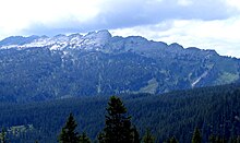
View over the highest mountain in the Emmental Alps. |
|
| Highest peak | Brienzer Rothorn ( 2350 m above sea level ) |
| location |
|
| part of | Western alps |
| Coordinates | 639 636 / 187 206 |
| surface | 1,800 km² |
The Emmental Alps ( Emmengruppe in the Geographical Lexicon of Switzerland ) are a mountain group on the northern edge of the Alps and are located in the Swiss cantons of Bern , Lucerne , Obwalden and Nidwalden . The Bernese Oberland already begins in its southern part (mountain ranges north of Lake Thun and Lake Brienz ) . The group is surrounded by the Swiss Plateau , the Uri , Bern and Friborg Alps. The Lucerne Entlebuch is at its center. The highest point is the Brienzer Rothorn above the northern shore of Lake Brienz, where three cantons meet.
It is named after the Emmental with the river Emme .
Boundary
The Emmental Alps are bordered (clockwise, starting from the north) by Kleiner Emme , Vierwaldstätter and Alpnachersee , Sarner Aa , Lungerersee , Brünigpass , Brienzersee , Thunersee , Aare , Chise , Schüpbachkanal, Emme , Grüene , Griesbach, Rotbach , Langete , Luthern and Seewag and cover an area of 1,800 km 2 .
The altitude range extends from 429 m above sea level. M. ( Emmen ) up to 2350 m above sea level. M. (Brienzer Rothorn).
structure
Hohgant, Sigriswiler- and Güggisgrat
In the center of the Emmental Alps there is a dominant mountain range that stretches from the southwest to the northeast. To the north of this chain there is a shallower basin towards the central plateau. The mountain range begins with two parallel massifs that run from Lake Thun to the northeast. The Sigriswilergrat is the northern and the Güggisgrat is the southern. After about six kilometers, the mountain ridge of the seven stallions follows between the two . This is separated from the Hohgant massif after three kilometers by the Grünenbergpass .
Schrattenfluh, Beichlen, Rämisgummen
After another seven kilometers, the deep valley of the Emme separates the Schrattenfluh mountain range . This stick ends with the Waldemme after six kilometers and there are several lower and smaller ridges in the northeast, including the Beichlen .
Pilate
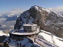
The terrain then flattens out a little until the Pilatus massif joins Lake Lucerne .
Giswiler Stocks and Brienzergrat
The Brienzergrat is located between Hohgant and Lake Brienz , the highest peak of which (Brienzer Rothorn) is also the highest of the entire group.
Napf area
The most northerly subgroup that extends into the Swiss Plateau is the Napf area with the Napf as the highest mountain.
geology
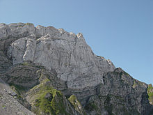
The geological subsurface is formed by formations of limestone , flysch and molasses . Limestone from the Cretaceous period can be found mainly in the Pilatus, Schrattenfluh, Hohgant, Güggisgrat and Sigriswilgrat areas. The Schrattenkalk is criss-crossed by extensive cart fields and cave systems . The layers of the subalpine molasse sandstone , Nagelfluh and marl can be found upstream of the Helvetic fringe . The marginal chain is underlain by flysch, the soft rock of which enabled the entire chalk package to be pushed over the subalpine molasse. As the top floor of the chain, there are still rocks from the tertiary formation (Hohgantsandstein, Lithothamnienkalk). The Giswilerstocks occupy a special position. They are a remnant (cliff) of the otherwise completely eroded Pennine ceiling.
summit
Elevations in the Emmental Alps that reach a height of around 2,000 meters and more.
| mountain | height | Affiliation |
|---|---|---|
| Brienzer Rothorn | 2350 m | Brienzergrat |
| Tannhorn | 2221 m | Brienzergrat |
| Furggengütsch | 2197 m | Hohgant |
| Letter horn | 2165 m | Brienzergrat |
| Steinigi mat | 2163 m | Hohgant |
| Tomlishorn | 2129 m | Pilate |
| ass | 2119 m | Pilate |
| stallion | 2093 m | Schrattenfluh |
| Hächlen | 2089 m | Schrattenfluh |
| Ram field (pilatus) | 2075 m | Pilate |
| Burgfeldstand | 2064 m | Güggisgrat |
| Hohgant West | 2063 m | Hohgant |
| Gemmenalphorn | 2061 m | Güggisgrat |
| Sigriswiler Rothorn | 2051 m | Sigriswilergrat |
| Ällgäuhorn | 2047 m | Brienzergrat |
| Matthorn | 2041 m | Pilate |
| Schibengütsch | 2037 m | Schrattenfluh |
| Midday horn | 2014 m | Sigriswilergrat |
| Niederhorn | 1963 m | Güggisgrat |
| Bowl | 1406 m | Napf area |
Flora and fauna
flora
The limit of distribution for firs is 1,800 meters, for beech at 1,600 meters and for ash at 1,400 meters. In the forests around Entlebuch, the forest is almost exclusively made up of spruce , and there is hardly any mixed forest . Larger mountain pine forests can be found on the southern slopes of the Hohgant .
fauna
There are some ibex colonies in the areas of Eigental , Hohgant and Brienzer Rothorn .
Web links
literature
- Oskar Allgäuer: Central Swiss Pre-Alps , Volume III, The Pre-Alps between Brünig Pass and Lake Thun (Lucerne Pre-Alps). SAC hiking, climbing and ski touring guide, Lucerne (1932)
- Willy Auf der Maur: Central Swiss Prealps , SAC (1996)
Individual evidence
- ^ Charles Knapp, Maurice Borel, Victor Attinger, Heinrich Brunner, Société neuchâteloise de geographie (editor): Geographical Lexicon of Switzerland . Volume 1: Aa - Emmengruppe . Verlag Gebrüder Attinger, Neuchâtel 1902, pp. 704–704, keyword Emmengruppe ( scan of the lexicon page ).
- ↑ Classification of the Western Alps according to “Johannes Führer in Bergwelt 11/1979 & 1/1980”. Accessed on March 8, 2009
- ↑ Ernst Höhne: Knaurs Lexikon für Bergfreunde / The Alps between Matterhorn and Lake Constance . Droemer Knaur, Munich 1987, ISBN 3-426-26223-1 , p. 89 ff .
- ↑ The height distribution of ash, beech and fir in the Lucerne Prealps. Accessed on March 8, 2009


