Güggisgrat
| Güggisgrat | ||
|---|---|---|
|
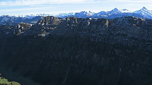
Güggisgrat from the northwest, seen from the Sigriswiler Rothorn; Burgfeldstand is the highest point on the right and Gemmenalphorn on the left |
||
| height | 2063 m above sea level M. | |
| location | Pre-Alps , Switzerland | |
| Mountains | Emmental Alps | |
| Dominance | 8.8 km → Hohgant | |
| Notch height | 508 m ↓ Grünenberg Pass | |
| Coordinates | 627 232 / 174 639 | |
|
|
||
| Development | 1946 by chairlift to the Niederhorn | |
The Güggisgrat ( [ɡʏkisˌɡraːt] ) is a multiple peaks ridge of the Emmental Alps in the Swiss canton of Bern .
location
The mountain stands northeast of Lake Thun and is characterized by its great independence (the notch height is 537 meters, the dominance 9.5 kilometers). The communities of Beatenberg and Sigriswil have a share in the Güggisgrat .
The striking Güggisgrat stretches for around 6 km to the northeast to the saddle of Oberberg. The peaks of the Güggis ridge are from southwest to northeast the Niederhorn ( 1950 m above sea level ), Beatenberg's local mountain, the main summit Burgfeldstand at 2063 m above sea level. M. and the Gemmenalphorn ( 2061 m above sea level ). The Güggisgrat slopes down towards the northwest to the Justistal valley with a steep slope criss-crossed by wide rock bands . At a distance of two kilometers, the Sigriswilergrat runs parallel to the Güggisgrat , so that the Justistal is a U-valley with up to 800 m high valley flanks. Towards the south-east, the ridge has a significantly lower slope, here there are extensive alpine meadows (Gemmenalp, Burgfeld).
geology
From a geological point of view, the Güggisgrat is made up of sediments from the Helvetic Mountains, which were deposited around 225 to 65 million years ago on the northern edge of the ancient Mediterranean Sea, Tethys . These layers were only included in the folding of the Alps relatively late, around 20 million years ago. The rugged rock walls in the upper part of the Güggisgrat are made of Schrattenkalk . This is followed by marly and calcareous series of the Drusberg layers and the Kieselkalk, all sediments from the Cretaceous period . Above the Schrattenkalk there is a layer of the Hohgant series, mainly sandstone , in the summit area .

