Niederhorn
| Niederhorn | ||
|---|---|---|
|
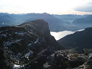
Niederhorn seen from the northeast with Lake Thun and Niesen opposite |
||
| height | 1963 m above sea level M. | |
| location | Bernese Oberland , Switzerland | |
| Mountains | Emmental Alps | |
| Dominance | 1.15 km → Burgfeldstand | |
| Notch height | 46 m ↓ unnamed notch | |
| Coordinates | 625852 / 173 441 | |
|
|
||
| Development | 1946 by chairlift | |
|
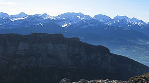
Niederhorn from the north in front of Blüemlisalp in the center of the picture and Gspaltenhorn on the horizon to the left of the transmitting antenna |
||
The Niederhorn is 1963 m above sea level. M. high summit of the Emmental Alps in the Bernese Oberland and is considered the local mountain of Beatenberg in Switzerland .
location
The Niederhorn lies above Lake Thun and is the first summit of the Güggis ridge when viewed from the west . The ridge rises east of the Niederhorn to 2063 meters at the Burgfeldstand and again to 2061 meters at the Gemmenalphorn , with some unnamed elevations in between. At the eastern foot at about 1700 meters is the Seefeld nature reserve with the karst area of the Seven Stallions , the highest peak of which reaches 1952 meters again.
The Niederhorn is a foothills of the Alps, from which the chain of the Bernese Alps can be seen well. In the south and west lies the Thunersee, at the northern foot of the Güggis ridge lies the Justistal , where the famous Käseteilet takes place in September . The Sigriswilergrat rises on the opposite northern side .
Development
As early as 1912, the Beatenbergbahn was in possession of the concession documents for the development of the Niederhorn. It was therefore the main initiator of the construction of the Beatenberg-Niederhorn (SBN) sports track, which began in 1945, and contributed 300,000 francs of share capital, as well as providing a large guarantee.
The first lift to the summit of the Niederhorn was put into operation in 1946. It was a chairlift that was replaced in 1997 by a 3-cable group gondola . The current railway is the first and so far only such railway in Switzerland. The train has four groups with three cabins each, each with a capacity of 17 people. In addition to the Beatenberg valley station and the mountain station, there is the Vorsass intermediate station halfway.
At the mountain station of the Niederhornbahn there is a restaurant with a children's playground as well as a lookout point with a panorama board above. The summit can be reached via several marked hiking trails. In winter, prepared winter hiking trails, snowshoe trails and toboggan runs as well as a ski lift are available.
Transmission tower
On the Niederhorn there is a transmission system for VHF and TV , which uses an 89-meter-high, free-standing steel lattice tower as an antenna carrier, which was built from 1972 to 1975. The programs Radio SRF 1 (frequency 93.6 MHz), Radio SRF 2 Kultur (97.2 MHz) and Radio SRF 3 (105.8 MHz) are broadcast, each with an effective radiation power of 4 kW .
Web links
Individual evidence
- ^ Anniversary publication 1889-1989 / 100 years Thunersee-Beatenbergbahn
- ↑ Niederhornbahn in the Swiss cable car inventory
- ↑ Information on leisure activities on the Niederhorn
- ↑ Bandscan in Emmental, home.arcor.de, accessed on November 15, 2009


