
Sigriswil
| Sigriswil | |
|---|---|
 |
|
| State : |
|
| Canton : |
|
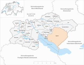
| Administrative district : | Tuna |
| BFS no. : | 0938 |
| Postal code : | 3655 Sigriswil 3654 Gunten 3656 Tschingel ob Gunten 3657 Schwanden near Sigriswil 3658 Merligen |
| Coordinates : | 621258 / 173977 |
| Height : | 810 m above sea level M. |
| Height range : | 558-2063 m above sea level M. |
| Area : | 55.41 km² |
| Residents: | 4833 (December 31, 2018) |
| Population density : | 87 inhabitants per km² |
| Website: | www.sigriswil.ch |
 Sigriswil |
|
| Location of the municipality | |
  |
|
Sigriswil is a municipality in the Thun administrative district in the canton of Bern in Switzerland .
geography
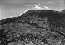
Most of the Sigriswil community is located on a sun terrace above the right bank of Lake Thun . It stretches from its bank (560 m) up to Blueme (1392 m) and to Sigriswilergrat (Sigriswiler Rothorn 2051 m). A smaller (rear) part of the municipality is located on the northern and eastern slopes of the Blueme and on the western slopes of the rear Sigriswilergrat and belongs to the catchment area of the Zulg , which only flows into the Aare after Thun.
The community consists of 11 localities: Aeschlen ob Gunten , Gunten , Meiersmaad, Merligen , Ringoldswil, Schwanden, Sigriswil, Tschingel ob Gunten, Wiler, Endorf and Reust as well as the Justistal . The villages of Meiersmaad and Reust are located in the rear part of the municipality.
Surname
The name Sigriswil is made up of the Old High German personal name Sigiheri or Sigirih and the place name ending -wilari (small village, hamlet).
history
Early history
Stone Age finds in Gunten, Bronze Age finds in Merligen, Gunten, Sigriswil, Ringoldswil and Justistal. Place and field names indicate a reclamation in Alemannic times. The frequently expressed claim that the name Tschingel , which comes from the Latin cingulum , proves a reclamation in Roman times, is not tenable. Tschingel is one of the Romansh loanwords that occur frequently in the Bernese Oberland and that was preserved in Alemannic times. Therefore, such words are not considered for an evaluation of settlement history. The word Gunten was wrongly described in older research as a word from Roman times. Today it is considered a Romanesque loan word of Gallic origin.
middle Ages
In the 10th century the area of the municipality belonged to the Duchy of Swabia, in the 11th century to the Kingdom of Hochburgund, with which Sigriswil returned to the kingdom in 1033. In the centuries that followed, the originally free farmers became dependent on secular and spiritual landlords. In the 13th century Sigriswil belonged to the Freiherrschaft Oberhofen by feudal rights, after the murder of Albrecht I von Habsburg (1308) with the participation of Walter III. from Eschenbach, Oberhofen and thus Sigriswil came under Austrian rule. In 1313 Sigriswil became a Kyburg imperial fief, was sold to Bern in 1323 and was returned as a fief. In 1347 the Hochwaldregal was bought by the (indebted) Count Eberhard II of Kyburg-Burgdorf (Sigriswiler freedom letter); 1406 Bernese rule; Freigericht together with Steffisburg until 1471, then own court until 1798. 1627 Incorporation of the Justistal into the municipality. During the Helvetic to Canton Oberland, from 1803 to 1832 again free court.
The original community is a purely economic property and utility community; it received the small jurisdiction under manorial administration. In the 15th century there was a strong immigration and the inner isolation of the indigenous population from the newcomers.
reformation
In 1525 Albrecht Vogt, the canon of Interlaken, was sent to Sigriswil as a folk priest. He took part in the Bern disputation of 1528 and signed the Reformation theses there. As a result, he was commissioned to introduce the Reformation in Sigriswil. In contrast to other regions in the Bernese Oberland, the Reformation in Sigriswil was accepted without resistance. In 1529 a choir court was set up in every parish, which enforced strict church discipline. The Sigriswiler tolerated the pilgrimage for pilgrimages to the Beatus caves . The government had the caves walled up for the first time in 1528, and the church and pilgrims' hostel destroyed. The Catholic Unterwaldners did not allow themselves to be deterred from further pilgrimages and broke open the wall again; so the walling up and breaking up went on several times. As a counterbalance to the cult around the Beatus Caves, the Bern government had an Evangelical Reformed church built on the Beatenberg from 1534 to 1535 .
Modern times
In 1650, the Seyordnung regulates the relationship between long-time residents and those behind the scenes, as well as between the upper villages and the village of Merligen, about the unclear use of common land. Since 1690 civic community with a personal right to a certificate of origin. Due to the new cantonal municipal law, a new municipal code (community of residents) was adopted in 1832. The new constitution of 1831 left everything in the community organization as it was. The burger estates remained untouched as private property, which meant that the newly created community lacked the financial means. In 1851, therefore, a mixed community was created to balance the interests of the citizen and resident community; In 1868 the general civic property was finally handed over to the community and the civic community was dissolved. In the middle of the 19th century, there were party battles between liberals and conservatives who opposed road building; 1852 Construction of the Seestrasse to Gunten, 1873 extension to Merligen, then continuous expansion of the road network.
In 1908, the community assembly decided to financially participate in a cable car between Gunten and Siriswil. The financial outlay for a railway turned out to be too great, and in 1914 the decision was made in favor of automobile traffic. Post and telegraph reached the community at the end of the 19th century, telephone connections at the beginning of the 20th century. Other tasks of the community in the second half of the 19th century were torrent barriers, afforestation, surveying work, water catchments and school building. In 1898 a village fire took place in Merligen, which destroyed part of the village.
Sigriswil Church
The first church in Sigriswil was built around 1000 by Rudolf II of Hochburgund (Strättliger Chronik); Until the Reformation he belonged to the diocese of Constance; Patronage In the 13th century with the nobles von Bremgarten, Burkhard von Unspunnen and others, from 1222 at the Interlaken monastery, after the Reformation near Bern, but with its own choir court. Reconstruction in the middle of the 15th century (late Gothic foundations), 1678/79 new building in the style of the Protestant preaching church. Further renovations in 1784, 1838, 1866 and 1957. Patron saint St. Gallus. 1937 Inauguration of the Merligen Church. Pastors Christoph Pfäfferlin (1555–1565) as a humanist and botanist, Gottlieb Jakob Kuhn (1799–1806) as a poet and Karl Howald (1833–1869) as a chronicler have left traces beyond their office . In 1925, to commemorate Gottlieb Jakob Kuhn's 150th birthday , a bronze relief created by Hermann Hubacher was attached to the right of the church entrance.
economy
The agriculture originally three-field economy with free farmers. Vine growing on Lake Thun probably began in Roman times. Self-sufficiency in bread and wine for the community. In the 18th century, grass farming was introduced (stable feeding), increased milk production and crop rotation, as well as the introduction of potatoes and a decline in arable farming. At the end of the 18th century, the decline in viticulture due to the degeneration of the vines. In 1851 and 1858, protective provisions and a new forest law regulate the use of the forest and put an end to overexploitation through agriculture. In the 20th century, the number of farms decreased and expanded, the number of cows increased and the arable land continued to decline.
Agriculture remained the main branch of the economy until the beginning of the 19th century; 1831 introduction of the freedom of trade, increase in catering and trade; 1858 start of tourism (first advertising leaflet); In the 20th century, Sigriswil is no longer a purely rural community; many earn their earnings in the hotel industry, in trade, commerce and transport as well as in the factories in Thun.
politics
The voting shares of the parties in the 2015 National Council election were:
- SVP 56.1%,
- BDP 10.5%,
- SP 9.4%,
- FDP 6.5%,
- GPS 5.4%,
- glp 3.3%,
- EVP 3.1%,
- EDU 2.1%,
- Alpine Parliament 1.2%,
- CVP 1.0%.
traffic
Sigriswil is served by the bus lines 21 and 25 of the STI transport company, the former in turn replaced the Thun – Beatenbucht trolleybus that ran between 1952 and 1982 . From 1913 to 1952, the Steffisburg – Thun – Interlaken tram ran on the section .
Attractions
Cultural and historical tours
The cultural and historical tours lead through Sigriswil, Endorf, Merligen and Gunten.

Municipal vault
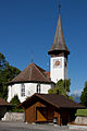
Reformed Church Sigriswil

Speicher and Schiffsscherm, Merligen
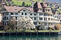
Hotel Hirschen, Gunten


Customs and miscellaneous
The Chästeilet ( Bern German for cheese distribution ) is an annual festival in the Justistal .
The festival takes place on the Friday before or after the Federal Thanksgiving, Repentance and Prayer Day. The exact date is always set one year in advance by the United Alpine Cooperatives. On Chästeilet the farmers that their cows have summered in Justistal meet and share the produce in the summer cheeses on in relation to the milk yield of cows. Even before and during the traditional ritual, a happy festival begins with yodelling songs and the sounds of Schwyzerörgeli .

Chästeilet in the Justistal

Cheese is stacked per lot

Memorial plaque to Gottlieb Jakob Kuhn, folk song writer


The minor planet (104896) discovered in the Drebach observatory (Ore Mountains) officially bears the name Schwanden after the village in Sigriswil.
Personalities
- Gottlieb Jakob Kuhn (1775–1849), vicar in Sigriswil from 1799 to 1806
- Philipp Woker (1848–1924), historian, professor at the University of Bern; Father of Gertrud and Harald Woker; Grave site: Stampach (House Woker)
- Karl Howald (1796–1869), pastor in Sigriswil from 1833 to 1869, author of a seven-volume Sigriswiler Chronik (1844–69)
- Gertrud Woker (1878–1968), biochemist, professor at the University of Bern, activist of the International Women's League; born in Stampach (House Woker)
- Curt Goetz (1888–1960), actor and writer, owned a holiday home in Merligen from 1927, in which he lived with his wife Valérie von Martens (1894–1986) from 1933 to 1939.
- Otto Erich Strasser (1888–1985), Protestant clergyman and university professor
- Zenta Mauriņa (1897–1978), Latvian writer, essayist and translator, wrote: "You had found your way to Sigriswil, where the snow-capped mountains boast the glory of the Creator, and Lake Thun the depth of his thoughts."
- George Gallup (1901–1984), American pioneer of market and opinion research , died in the Sigriswil district, Tschingel ob Gunten
- Adrian Amstutz (* 1953), Swiss politician (SVP), born in Sigriswil and from 1993 to 1998 President of the City Council
- Christoph Sauser (* 1976), Swiss mountain biker
literature
- Matthias Bürgi: Early forms of forest use in the Sigriswil forest . In: Swiss journal for forestry . tape 145 , 1994, pp. 669-676 .
- Matthias Bürgi: Traces in the Sigriswil landscape . In: Yearbook of Lake Thun and Lake Brienz . 1994b, p. 14-45 .
- Anne-Marie Dubler : The Thun-Oberhofen region on its way to the Bernese state . In: Bern journal for history and local history . tape 66 , no. 2 , 2004, p. 61-117 .
- Wilhelm Gafner: Sigriswil . Sigriswil 1977.
- Max Grütter: Thousand-year-old churches on Lake Thun and Lake Brienz . Paul Haupt, Bern 1956.
- Johann Ulrich Hubschmied : About place names of the Thun office . Adolf Schär, Thun 1943.
- Berchtold Lenherr: Changes in rural self-sufficiency in the Sigriswil-Schwanden-Beatenberg area . In: Bern journal for history and local history . No. 41 , 1979, pp. 45-80 .
- Thomas Lindt: Sigriswil Church . Sigriswil 1985.
- H. Rennefahrt: The Thun Office - A local lore . tape 1 . Adolf Schär, Thun 1943, overview of developments in constitutional law, p. 197-229 .
- Adolf Schär-Ris: Sigriswil: A local lore . Büchler, Bern.
- Adolf Schär-Ris: 1347–1947 - Six Hundred Years of Sigriswil: Historical commemorative publication for the 600th anniversary of the eleven villages of Sigriswil . Sigriswil 1947.
- Adolf Schär-Ris: Sigriswil . Paul Haupt, Bern 1979.
- Bernhard Stettler: Studies on the history of the Upper Aare area in the early and high Middle Ages . Publishing house Stadtkanzlei Thun, Thun 1964.
- Otto Tschumi: Prehistory and early history of the Thun office . Adolf Schär, Thun 1943.
Partner communities
-
 Lutry , Canton of Vaud , Switzerland . The partnership began in 1981 when the canton of Bern took part in the Comptoir Suisse in Lausanne as a guest.
 -
 Villa General Belgrano , Province of Cordoba (Argentina) , Argentina . The partnership was signed in November 2010.
Web links
- Official website of the municipality of Sigriswil
- Anne-Marie Dubler : Sigriswil. In: Historical Lexicon of Switzerland .
Individual evidence
- ↑ Permanent resident population from STAT-TAB of the BfS , municipalities see also regional portraits 2020 on bfs.admin.ch, accessed on May 29, 2020
- ↑ Roger Probst: Sigriswiler did not defend themselves against the Reformation , Berner Zeitung, Bern May 11, 2017
- ↑ 1925, bronze relief by Hermann Hubacher, p. 66.
- ↑ Results of the Sigriswil community. State Chancellery of the Canton of Bern, October 18, 2015, accessed on October 30, 2016 .
- ↑ Sigriswil cultural and historical tours
- ↑ JPL Small-Body Database Browser. In: ssd.jpl.nasa.gov. Retrieved October 17, 2012 .
- ↑ From: Zenta Maurina: My Song of the Earth. Routes . Maximilian Dietrich Verlag, Memmingen 1976, p. 8.
Amsoldingen | Flower stone | Buchholterberg | Burgistein | Eriz | Fahrni | Forst-Längenbühl | Gurzelen | Heiligenschwendi | Heimberg | Hilterfingen | Homberg | Horrenbach beeches | Oberhofen am Thunersee | Oberlangenegg | Pohlern | Reutigen | Juicy | Sigriswil | Steffisburg | Stocken-Höfen | Teuffenthal | Thierachern | Tuna | Uebeschi | Uetendorf | Unterlangenegg | Uttigen | Wax thorn | Wattenwil | Zwieselberg
Former municipalities: Forst | Goldiwil | Höfen bei Thun | Kienersrüti | Längenbühl | Stocking down | Oberstocken | Schwendibach | Strättligen | Tannenbühl | Thung snow
Canton of Bern | Administrative districts of the canton of Bern | Municipalities of the Canton of Bern