
Hof bei Thun
| Hof bei Thun | ||
|---|---|---|
 |
||
| State : |
|
|
| Canton : |
|
|
| Administrative district : | Tuna | |
| Residential municipality : | Stocken-Höfe | |
| Postal code : | 3631 | |
| former BFS no. : | 0930 | |
| Coordinates : | 609 508 / 174 541 | |
| Height : | 705 m above sea level M. | |
| Area : | 4.62 km² | |
| Residents: | 444 (December 31, 2013) | |
| Population density : | 96 inhabitants per km² | |
 Uebeschisee |
||
| map | ||
|
||


Until December 31, 2013, Höfen (official name) was a political municipality in the Thun administrative district in the canton of Bern in Switzerland . On January 1, 2014, Höfen merged with the former municipalities of Niederstocken and Oberstocken to form the new municipality of Stocken-Höfen .
geography
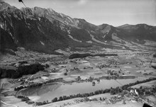
This place is located at a height in a hilly landscape between the Stockental on the one hand and the Amsoldinger and Uebeschisee on the other, southwest of Thun. Except for the Uebeschisee , of which the majority with an area of 10 hectares belongs to Höfe despite its name - and not to the neighboring municipality of Uebeschi - there are no bodies of water in the municipality, the northeastern municipal boundary runs along the shores of the Amsoldingersee, which is entirely on the Area of the municipality Amsoldingen is located. In the south-east of the municipality there is a large piece of forest with the Beisseren . In the past the community did not have a main settlement, but in the last few decades one has developed between the hamlets of Kistleren , Schindleren and Speckhubel . There are also numerous other groups of houses and individual farmsteads in Höfen. 74.8% of the total community area of 462 ha is used for agriculture. Forest and wood cover 15.6% and settlement areas 4.6% of the municipal area.
Until December 31, 2013, Höfen bordered Oberstocken and Reutigen in the south, Zwieselberg in the east, Amsoldingen in the northeast , Uebeschi in the northwest and Pohlern in the west .
population
At the beginning of 2005 the community had 399 inhabitants.
languages
The population speaks a high Alemannic dialect in everyday life , which is one of the dialects of Bern German . In the last census in 2000, 98.74% said German and 0.25% French and Romansh were the main languages.
Religions - denominations
In earlier times the entire population was members of the Evangelical Reformed Church.
Origin - nationality
At the beginning of 2005 396 residents (= 99.25%) were Swiss nationals and three people were immigrants from other countries.
politics
The voting shares of the parties on the occasion of the National Council elections in 2011 were: SVP 49.8%, BDP 12.9%, GPS 10.4%, SP 8.4%, EDU 4.9%, glp 4.6%, FDP 2.7 %, EPP 1.6%, Alpine Parliament 1.2%, CVP 1.2%.
economy
Most of the people who work in the village still live from agriculture. But the majority of those who work on farms are commuters (especially to Thun).
traffic
The village center is connected to the public transport network by bus line 3 of the STI Thun-Höfen-Blumenstein. The north-western and south-eastern parts of the municipality, however, are not accessible by public transport.
The parts of the community accessed by bus are on the road from Amsoldingen to Oberstocken. All other districts can only be reached on small side streets. The closest motorway connection is Thun-Süd on the A6 .
Attractions
Web links
- Official website of the municipality of Stocken-Höfen
- Anne-Marie Dubler : Courtyards. In: Historical Lexicon of Switzerland .
Individual evidence
- ↑ http://www.wahlarchiv.sites.be.ch/wahlen2011/target/NAWAInternetAction.do@method=read&sprache=d&typ=21&gem=930.html accessed on July 16, 2012
Amsoldingen | Flower stone | Buchholterberg | Burgistein | Eriz | Fahrni | Forst-Längenbühl | Gurzelen | Heiligenschwendi | Heimberg | Hilterfingen | Homberg | Horrenbach beeches | Oberhofen am Thunersee | Oberlangenegg | Pohlern | Reutigen | Juicy | Sigriswil | Steffisburg | Stocken-Höfen | Teuffenthal | Thierachern | Tuna | Uebeschi | Uetendorf | Unterlangenegg | Uttigen | Wax thorn | Wattenwil | Zwieselberg
Former municipalities: Forst | Goldiwil | Höfen bei Thun | Kienersrüti | Längenbühl | Stocking down | Oberstocken | Schwendibach | Strättligen | Tannenbühl | Thung snow
Canton of Bern | Administrative districts of the canton of Bern | Municipalities of the Canton of Bern