
Uttigen
| Uttigen | |
|---|---|
 |
|
| State : |
|
| Canton : |
|
| Administrative district : | Tuna |
| BFS no. : | 0885 |
| Postal code : | 3628 |
| Coordinates : | 610 517 / 182750 |
| Height : | 544 m above sea level M. |
| Height range : | 535–606 m above sea level M. |
| Area : | 3.81 km² |
| Residents: | 2103 (December 31, 2018) |
| Population density : | 552 inhabitants per km² |
| Mayor : | Beat Fischer ( SVP ) |
| Website: | www.uttigen.ch |
 Uttigen |
|
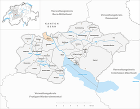
| Location of the municipality | |
  |
|
Uttigen is a municipality in the Thun administrative district in the canton of Bern in Switzerland . On January 1, 2014, the former municipality of Kienersrüti was incorporated into the municipality of Uttigen.
geography
Uttigen lies at 544 m above sea level. M. , 6 km northwest of the city of Thun (linear distance). The village extends on both sides of the Glütschbach on the western edge of the Aare valley , at the foot of the Hubel , a southern branch of the Belpberg , on the border with the Bernese Oberland .
The area of the 3.1 km² municipal area comprises a section of the wide Aare valley between Bern and Thun. The eastern border is formed by the channeled and straightened Aare, which is flanked here by a forest belt. To the west, the municipality extends over the flat valley floodplain with the forest area Obere Au and the agricultural areas on both sides of the Glütschbach up to the adjacent heights. On the wooded Hubel is at 606 m above sea level. M. reached the highest point in Uttigen. To the north, the municipal ban extends to the plateau, which represents the southeastern foothills of the Belpberg and was shaped by the Ice Age Aar glacier. This plateau slopes steeply towards the east to the Aare, which, with its erosion force, has modeled the Nagelfluh rocks on the Prallhang . In 1997, 20% of the municipal area was accounted for by settlements, 33% for forests and woodlands and 44% for agriculture; slightly less than 3% was unproductive land.
Various individual farms belong to Uttigen. The neighboring communities of Uttigen are Kiesen , Heimberg , Uetendorf , Kirchdorf (BE) and Jaberg .
history

The place was first mentioned in a document in 894 under the name Utingun . Later the names Utingen (1259), Uttingen (1295) and Utthingen (1300) appeared. The etymology of the place name is not clear. Some sources derive the place name from the Celtic (meaning: fertile place ), others lead it back to the Old High German personal name Uto or Utto .
In the Middle Ages there was a castle square on the plateau on the western edge of the Aare valley, about the origins of which little is known. The almost square square had an area of around 1400 m² and was often referred to as the city and fortress Uttigen in the documents of the 13th and 14th centuries . The nobles of Wädenswil have been the owners of the estate since 1271. In the 13th century the barons of Kramburg took their place, who made Uttigen their ancestral seat. After the Kramburger family died out, the village underwent various changes of ownership before it came into the possession of the Thun Hospital in the 15th century. Uttigen had had a house of worship since the 10th century, but it was destroyed by fire in 1536. As a result, no new church was built because the community could not afford it. The village therefore joined the Kirchdorf parish to which it still belongs today.
Under the rule of Bern, Uttigen was subordinate to the Seftigen district court. After the collapse of the Ancien Régime (1798), the village belonged to the Seftigen district during the Helvetic period and from 1803 to the Seftigen district, which received the status of an official district with the new cantonal constitution of 1831. From 1884 the Aare was corrected in the Uttigen area and provided with flood protection dams.
population
With 2103 inhabitants (as of December 31, 2018), Uttigen is one of the medium-sized communities in the canton of Bern. 96.2% of the residents are German-speaking, 0.7% French-speaking and 0.6% speak English (as of 2000). The population of Uttigen was 321 in 1850 and 407 in 1900. In the course of the 20th century the population rose continuously to 887 people (1970). Since then, there has been a significantly increased population increase combined with a doubling of the population within 30 years.
politics
The voting shares of the parties at the 2015 National Council election were: SVP 38.5%, SP 15.0%, BDP 11.1%, GPS 7.2%, EVP 7.2%, FDP 6.4%, glp 5.7 %, EDU 4.8%, CVP 1.7%.
economy
Uttigen was a predominantly agricultural village until the second half of the 20th century . Even today, agriculture , dairy farming , cattle breeding and forestry have a certain role in the income structure of the population. Numerous other jobs are available in local small businesses and in the service sector. In Uttigen today there are companies in the building trade, IT, electrical engineering, metal construction, a gravel works and mechanical workshops. In the last few decades the village has developed into a residential community. Many employees are therefore commuters who work mainly in the Thun area, and sometimes also in the Bern agglomeration.
traffic
The community is very well developed in terms of traffic. It is located on a connecting road from Thun to Kirchdorf (BE) . The closest connection to the A6 motorway (Bern – Thun) is around 3 km from the town center. On July 1, 1859, the railway line from Bern to Thun with a train station in Uttigen went into operation; today the trains to Thun and Bern run every half hour.
Attractions
Only a few remains of the former Burgplatz and the ruins are visible. The site is privately owned. In the old town center some stately farmhouses from the 18th and 19th centuries in the Bernese style have been preserved. The landmark of Uttigen is the former (old) schoolhouse, which was built on the site of the medieval church, also from stones from the castle ruins, and has a church-like bell tower with a clock.
Sports
The place is also known for its roller hockey club, the RSC Uttigen , which won the title of Swiss champions in the National League A in 1999, 2000, 2002, 2003 and 2004. Furthermore, the roller hockey players have already reached the cup finals eight times, but most of the final games were just lost.
Web links
- Official website of the municipality of Uttigen
- Anne-Marie Dubler : Uttigen. In: Historical Lexicon of Switzerland .
Individual evidence
- ↑ Permanent resident population from STAT-TAB of the BfS , municipalities see also regional portraits 2020 on bfs.admin.ch, accessed on May 29, 2020
- ^ Results of the community of Uttigen. State Chancellery of the Canton of Bern, October 18, 2015, accessed on October 30, 2016 .
Amsoldingen | Flower stone | Buchholterberg | Burgistein | Eriz | Fahrni | Forst-Längenbühl | Gurzelen | Heiligenschwendi | Heimberg | Hilterfingen | Homberg | Horrenbach beeches | Oberhofen am Thunersee | Oberlangenegg | Pohlern | Reutigen | Juicy | Sigriswil | Steffisburg | Stocken-Höfen | Teuffenthal | Thierachern | Tuna | Uebeschi | Uetendorf | Unterlangenegg | Uttigen | Wax thorn | Wattenwil | Zwieselberg
Former municipalities: Forst | Goldiwil | Höfen bei Thun | Kienersrüti | Längenbühl | Stocking down | Oberstocken | Schwendibach | Strättligen | Tannenbühl | Thung snow
Canton of Bern | Administrative districts of the canton of Bern | Municipalities of the Canton of Bern