
Teuffenthal
| Teuffenthal | |
|---|---|
 |
|
| State : |
|
| Canton : |
|
| Administrative district : | Tuna |
| BFS no. : | 0940 |
| Postal code : | 3623 |
| Coordinates : | 621426 / 180494 |
| Height : | 956 m above sea level M. |
| Height range : | 752-1396 m above sea level M. |
| Area : | 4.53 km² |
| Residents: | 174 (December 31, 2018) |
| Population density : | 38 inhabitants per km² |
| Website: | www.teuffenthal.ch |
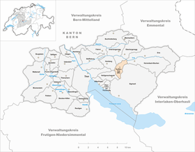
| Location of the municipality | |
  |
|
Teuffenthal (BE) is a municipality in the Thun administrative district in the canton of Bern in Switzerland .
It should not be confused with the community of Teufenthal in the canton of Aargau .
geography
Teuffenthal is located in a small side valley of the Zulg , about 10 km east of the city of Thun. The community is located in the Montanstufe, 770 - 1396 m above sea level on an area of 453 ha. There is no actual center, Teuffenthal consists of hamlets and individual farm settlements. There are no shops.
politics
The voting shares of the parties on the occasion of the 2015 National Council election were: SVP 70.1%, EDU 11.8%, EVP 7.2%, SP 4.8%, glp 1.7%, GPS 1.6%, BDP 1.2 %, FDP 0.7%, CVP 0.1%.
traffic
Teuffenthal is connected to the public transport network by the STI bus routes 33 via Homberg, Steffisburg and Thun.
particularities
The sewage treatment plant is worth mentioning. It is based on a so-called root space system. At the highest point of the community, the Blueme, there is a lookout tower that allows a view of the Bernese Oberland, Mittelland and Emmental.
See also
Web links
- Official website of the municipality of Teuffenthal
- Anne-Marie Dubler : Teuffenthal. In: Historical Lexicon of Switzerland .
Individual evidence
- ↑ Permanent resident population from STAT-TAB of the BfS , municipalities see also regional portraits 2020 on bfs.admin.ch, accessed on May 29, 2020
- ^ Results of the municipality of Teuffenthal. State Chancellery of the Canton of Bern, October 18, 2015, accessed on October 30, 2016 .
Amsoldingen | Flower stone | Buchholterberg | Burgistein | Eriz | Fahrni | Forst-Längenbühl | Gurzelen | Heiligenschwendi | Heimberg | Hilterfingen | Homberg | Horrenbach beeches | Oberhofen am Thunersee | Oberlangenegg | Pohlern | Reutigen | Juicy | Sigriswil | Steffisburg | Stocken-Höfen | Teuffenthal | Thierachern | Tuna | Uebeschi | Uetendorf | Unterlangenegg | Uttigen | Wax thorn | Wattenwil | Zwieselberg
Former municipalities: Forst | Goldiwil | Höfen bei Thun | Kienersrüti | Längenbühl | Stocking down | Oberstocken | Schwendibach | Strättligen | Tannenbühl | Thung snow
Canton of Bern | Administrative districts of the canton of Bern | Municipalities of the Canton of Bern