
Teufenthal
| Teufenthal | |
|---|---|
 |
|
| State : |
|
| Canton : |
|
| District : | Kulm |
| BFS no. : | 4145 |
| Postal code : | 5723 |
| Coordinates : | 651103 / 242326 |
| Height : | 446 m above sea level M. |
| Height range : | 438–631 m above sea level M. |
| Area : | 3.57 km² |
| Residents: | 1637 (December 31, 2019) |
| Population density : | 459 inhabitants per km² |
|
Proportion of foreigners : (residents without citizenship ) |
25.9% (December 31, 2019) |
| Website: | www.teufenthal.ch |
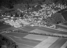
 Entrance to the village of Teufenthal |
|
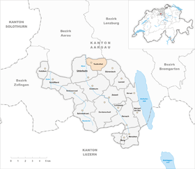
| Location of the municipality | |
  |
|
Teufenthal ( Swiss German Töüffetu , ˈtœːʏfːəˌtʊ ) is a municipality in the Swiss canton of Aargau . It belongs to the Kulm district and is located in the central Wynental . The municipality is not to be confused with Teuffenthal in the canton of Bern .
geography
The street village is located in the lower part of a narrow, three-kilometer-long side valley of the Wyna , which extends in an easterly direction to the Dürrenäsch plateau . It is bounded in the north by the foothills of the Surberg, in the south by the foothills of the Hohe Fels. Only a small part of the village lies in the valley of the Wyna, the river forms the western boundary of the municipality.
The area of the municipality is 357 hectares , of which 155 hectares are forested and 59 hectares are built over. The highest point is at 630 meters on the Bampf (an offshoot of the Surberg), the lowest at 438 meters on the Wyna. Neighboring communities are Gränichen in the north, Seon in the northeast, Dürrenäsch in the east and Unterkulm in the south. The northeastern border point is the Siebenzwingstein .
history
Töfendal was mentioned for the first time in 1173 in a letter of protection that Emperor Friedrich I issued "Barbarossa" to Beromünster Abbey . The place name goes back to the Old High German (ze demo) tiufen tale , which means "(near) the deep valley". In the Middle Ages the village was under the rule of the Counts of Lenzburg , from 1173 on that of the Counts of Kyburg . After these died out, the Habsburgs took over sovereignty and blood jurisdiction in 1273 . The lords of Trostburg owned the lower jurisdiction and had the castle of the same name built above the village in the 12th century.
In 1415 the confederates conquered Aargau. Teufenthal now belonged to the subject area of the city of Bern , the so-called Berner Aargau . In 1528 the Bernese introduced the Reformation . The Trostburg and the lower jurisdiction came into the possession of the Lords of Reinach in 1346 , and in 1486 to the Hallwyler . In 1616 they sold their property to the city of Brugg . However, Bern did not tolerate the increase in power of its subject city and took over the rights of rule. Teufenthal then formed part of the Trostburg judicial district within the Lenzburg office . In March 1798 the French took Switzerland, ousted the «Gracious Lords» of Bern and proclaimed the Helvetic Republic . Teufenthal has been part of the canton of Aargau since then.
In the second half of the 19th century the population decreased by about one sixth. The decline was far less pronounced than in numerous neighboring communities. From 1867, the tobacco industry was dominant for several decades. On March 5, 1904, the Wynental Railway opened . In 1921, the Injecta die casting foundry began operations, which for a long time shaped the community's economic life. Between 1900 and 1970 the population tripled. Since then, however, it has stagnated because the building land reserves in the small-scale community have largely been developed.
Attractions


The village center is dominated by the Trostburg from the 12th century , which stands on a thirty meter high rock spur.
coat of arms
The blazon of the municipal coat of arms reads: "Blue tip, overturned in yellow, with a rising yellow crescent moon, overlaid by a five-pointed yellow star." The coat of arms was first depicted on the municipal seal in 1811. The inverted tip indicates a deep valley between two mountains. The form of representation used today has been in use since 1953.
population
The population developed as follows:
| year | 1764 | 1803 | 1850 | 1900 | 1930 | 1950 | 1960 | 1970 | 1980 | 1990 | 2000 | 2010 |
| Residents | 377 | 457 | 666 | 537 | 694 | 1060 | 1350 | 1622 | 1564 | 1594 | 1598 | 1593 |
On December 31, 2019, 1637 people lived in Teufenthal, the proportion of foreigners was 25.9%. In the 2015 census, 42.6% described themselves as Reformed and 19.0% as Roman Catholic ; 38.4% were non-denominational or of other faiths. In the 2000 census, 85.7% named German as their main language, 6.8% Serbo-Croatian , 2.6% Italian and 2.2% Albanian .
Politics and law
The assembly of those entitled to vote, the municipal assembly , exercises legislative power. The executing authority is the five-member municipal council . He is elected by the people in the majority procedure, his term of office is four years. The parish council leads and represents the parish. To this end, it implements the resolutions of the municipal assembly and the tasks assigned to it by the canton. The Kulm District Court is the first instance responsible for legal disputes . Teufenthal belongs to the Friedensrichterkreis IX (Unterkulm).
economy
According to the corporate structure statistics (STATENT) collected in 2015, there were around 320 jobs in Teufenthal, 9% of them in agriculture, 33% in industry and 58% in the service sector. By far the largest company was Injecta AG , which closed in 2010 and specialized in die casting and had belonged to the Alu Menziken Group since 1988 . Most of the employed are commuters and work in the Reinach region or in Aarau and the surrounding area.
traffic

The village is on the main road 23 from Aarau via Beromünster to Sursee . Kantonsstrasse 250 leads via Dürrenäsch to Hallwil in the Seetal . The connection to the public transport network is made by the Wynentalbahn , which runs right next to the main road. From the Teufenthal stop, a bus line operated by Regionalbus Lenzburg leads to Seengen in the Seetal and on to Lenzburg train station . On weekends, a night bus runs from Aarau train station through the Wynental to Menziken .
education
The community has a kindergarten and a school house where primary school is taught. All upper levels of the compulsory elementary school ( Realschule , Secondary School and District School ) can be attended in Unterkulm . The closest grammar schools are the Alte Kantonsschule and the Neue Kantonsschule , both in Aarau .
Personalities
- Ludwig Karrer (1830–1893), National and Government Councilor
literature
- Markus Widmer-Dean: Teufenthal. In: Historical Lexicon of Switzerland .
- Michael Stettler : The art monuments of the canton of Aargau . Ed .: Society for Swiss Art History . Volume I: The districts of Aarau, Kulm, Zofingen. Wiese Verlag, Basel 1948, DNB 366495623 .
Web links
Individual evidence
- ↑ Cantonal population statistics 2019. Department of Finance and Resources, Statistics Aargau, March 30, 2020, accessed on April 2, 2019 .
- ↑ Cantonal population statistics 2019. Department of Finance and Resources, Statistics Aargau, March 30, 2020, accessed on April 2, 2019 .
- ↑ a b Beat Zehnder: The community names of the canton of Aargau . In: Historical Society of the Canton of Aargau (Ed.): Argovia . tape 100 . Verlag Sauerländer, Aarau 1991, ISBN 3-7941-3122-3 , p. 421-423 .
- ^ National map of Switzerland, sheets 1089 and 1109, Swisstopo.
- ↑ Standard area statistics - municipalities according to 4 main areas. Federal Statistical Office , November 26, 2018, accessed on May 26, 2019 .
- ^ Joseph Galliker, Marcel Giger: Municipal coat of arms of the Canton of Aargau . Lehrmittelverlag des Kantons Aargau, book 2004, ISBN 3-906738-07-8 , p. 290 .
- ↑ Population development in the municipalities of the Canton of Aargau since 1850. (Excel) In: Eidg. Volkszählung 2000. Statistics Aargau, 2001, archived from the original on October 8, 2018 ; accessed on May 25, 2019 .
- ↑ Resident population by religious affiliation, 2015. (Excel) In: Population and Households, Community Tables 2015. Statistics Aargau, accessed on May 26, 2019 .
- ↑ Swiss Federal Census 2000: Economic resident population by main language as well as by districts and municipalities. (Excel) Statistics Aargau, archived from the original on August 10, 2018 ; accessed on May 26, 2019 .
- ↑ circles of justice of the peace. Canton of Aargau, accessed on June 21, 2019 .
- ↑ Statistics of the corporate structure (STATENT). (Excel, 157 kB) Statistics Aargau, 2016, accessed on May 25, 2019 .