
Burg AG
| AG is the abbreviation for the canton of Aargau in Switzerland and is used to avoid confusion with other entries of the name Burg (disambiguation) . |
| Castle | |
|---|---|
 |
|
| State : |
|
| Canton : |
|
| District : | Kulm |
| BFS no. : | 4133 |
| Postal code : | 5736 |
| UN / LOCODE : | CH BRG |
| Coordinates : | 656090 / 231861 |
| Height : | 623 m above sea level M. |
| Height range : | 557–670 m above sea level M. |
| Area : | 0.94 km² |
| Residents: | 1004 (December 31, 2019) |
| Population density : | 1068 inhabitants per km² |
|
Proportion of foreigners : (residents without citizenship ) |
31.7% (December 31, 2019) |
| Website: | www.burg-ag.ch |
 Town center |
|
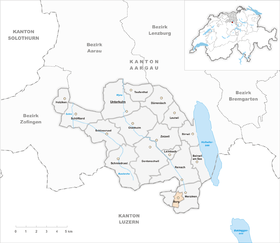
| Location of the municipality | |
  |
|
Burg is a municipality in the Swiss canton of Aargau . It belongs to the Kulm district , is located in the upper Wynental and borders the canton of Lucerne . With an area of 0.94 km², it is the second smallest municipality in the canton.
geography
The village is on the west side of the valley on the slope of the Stierenberg. The steep ravine of the Rickenbach, a tributary of the Wyna , forms the southern boundary of the municipality. In the west the terrain rises to the 861 meter high Stierenberg. The five villages of Burg, Beinwil am See , Menziken , Pfeffikon and Reinach have merged into a coherent agglomeration with around 20,000 inhabitants, the borders between the once separate settlements are barely recognizable.
The area of the municipality is 94 hectares , of which 21 hectares are forested and 33 hectares are built over. The highest point is at 668 meters, the deepest at 558 meters. Burg is almost completely enclosed by the area of the municipality of Menziken and is therefore almost an enclave. In the far southwest, Burg borders the municipality of Rickenbach in the canton of Lucerne over a length of just over 100 meters .
history
The origins of the village go back to Unter-Rinach Castle , built in the 12th century, the ancestral seat of the Lords of Reinach . These were a ministerial family of the Habsburgs and ruled over the upper Wynental. During the Sempach War in 1386, the Confederates destroyed the castle. The 15 meter high ruin had to give way to the new school building in 1872.
In 1412 two courtyards "near the castle" were mentioned for the first time. Three years later the Swiss conquered Aargau. Burg now belonged to the subject area of the city of Bern , the so-called Berner Aargau . The village was part of the Reinach court in the Lenzburg district . In 1528 the Bernese introduced the Reformation . For centuries, Burg had the status of an autonomous Steckhof and only received municipal rights from the City of Bern in 1751. In March 1798 the French took Switzerland, ousted the «Gracious Lords» of Bern and proclaimed the Helvetic Republic . Since then, Burg has belonged to the canton of Aargau.
Industry arrived early; Since around 1720 cotton has been processed at home . The textile industry was supplanted by the tobacco industry around 1860 . Burg and the upper Wynental developed into the center of Swiss cigar production and gained international importance. In addition to cigars, the Burg also produced harps , rakes and tiled stoves, among other things . The goldsmith's art was also of great importance. In the course of the 20th century the industry slowly migrated to the better developed neighboring communities and Burg became a residential community in the agglomeration of Oberwynental. Today Burg, Menziken , Pfeffikon and Reinach work closely together in numerous areas.
Attractions

_Lageto_156.jpg)
_lernejo_157.jpg)
coat of arms
The blazon of the municipal coat of arms reads: "In white on green ground, single-tower tinned, white jointed castle with openwork window, on the left side with a green fir tree." The coat of arms first appeared on the municipal seal in 1811. The castle, which is joined by a fir tree, is reminiscent of the former ancestral seat of the Lords of Rinach.
population
The population developed as follows:
| year | 1764 | 1803 | 1850 | 1900 | 1930 | 1950 | 1960 | 1970 | 1980 | 1990 | 2000 | 2010 |
| Residents | 154 | 298 | 463 | 563 | 662 | 883 | 939 | 1154 | 960 | 1142 | 991 | 987 |
On December 31, 2019, 1004 people lived in Burg, the proportion of foreigners was 31.7%. In the 2015 census, 30.3% described themselves as Reformed and 24.9% as Roman Catholic ; 44.8% were non-denominational or of another faith. In the 2000 census, 81.9% stated German as their main language, 4.8% Italian , 4.2% Turkish , 3.8% Albanian and 2.6% Serbo-Croatian .
Politics and law
The assembly of those entitled to vote, the municipal assembly , exercises legislative power. The executing authority is the five-member municipal council . He is elected by the people in the majority procedure, his term of office is four years. The parish council leads and represents the parish. To this end, it implements the resolutions of the municipal assembly and the tasks assigned to it by the canton. The Kulm District Court is the first instance responsible for legal disputes . Burg belongs to the Friedensrichterkreis IX (Unterkulm).
economy
According to the corporate structure statistics (STATENT) collected in 2015, there are around 320 jobs in Burg, of which 3% in agriculture, 57% in industry and 40% in the service sector. By far the most important company is the cigar group Burger Söhne . While the corporate headquarters remained in Burg, the Burg production site was given up in favor of Brissago . Other smaller industrial companies manufacture apparatus, precision measuring devices, threads and furniture. Many employees are commuters and work in Reinach or Menziken .
traffic
Burg is located away from through traffic on Kantonsstrasse 336 between Menziken and Rickenbach . The connection to public transport is via a Postbus line that runs from Beinwil am See via Menziken and Burg to the Sursee train station .
education
The community has a kindergarten and a school house where primary school is taught. All upper levels ( Realschule , Secondary School and District School ) can be attended in Menziken . The closest grammar schools are the Alte Kantonsschule and the Neue Kantonsschule , both in Aarau .
Personalities
- Adolf Aeschbach (1888–1969), politician
- Hans Aeschbach (1911–1999), graphic artist and painter
- Johann Burger (1829–1912), copperplate engraver
- Rudolf Burger (1839–1917), entrepreneur and politician
- Rudolf Burger (1864–1950), entrepreneur and politician
- Hesso von Reinach († 1275/76), minstrel
literature
- Hans Walti: Burg (AG). In: Historical Lexicon of Switzerland .
- Michael Stettler : The art monuments of the canton of Aargau . Ed .: Society for Swiss Art History . Volume I: The districts of Aarau, Kulm, Zofingen. Wiese Verlag, Basel 1948, DNB 366495623 .
Web links
Individual evidence
- ↑ Cantonal population statistics 2019. Department of Finance and Resources, Statistics Aargau, March 30, 2020, accessed on April 2, 2019 .
- ↑ Cantonal population statistics 2019. Department of Finance and Resources, Statistics Aargau, March 30, 2020, accessed on April 2, 2019 .
- ^ National map of Switzerland, sheet 1110, Swisstopo.
- ↑ Standard area statistics - municipalities according to 4 main areas. Federal Statistical Office , November 26, 2018, accessed on May 25, 2019 .
- ^ Beat Zehnder: The community names of the canton of Aargau . In: Historical Society of the Canton of Aargau (Ed.): Argovia . tape 100 . Verlag Sauerländer, Aarau 1991, ISBN 3-7941-3122-3 , p. 119-121 .
- ^ Joseph Galliker, Marcel Giger: Municipal coat of arms of the Canton of Aargau . Lehrmittelverlag des Kantons Aargau, book 2004, ISBN 3-906738-07-8 , p. 136 .
- ↑ Population development in the municipalities of the Canton of Aargau since 1850. (Excel) In: Eidg. Volkszählung 2000. Statistics Aargau, 2001, archived from the original on October 8, 2018 ; accessed on May 25, 2019 .
- ↑ Resident population by religious affiliation, 2015. (Excel) In: Population and Households, Community Tables 2015. Statistics Aargau, accessed on May 25, 2019 .
- ↑ Swiss Federal Census 2000: Economic resident population by main language as well as by districts and municipalities. (Excel) Statistics Aargau, archived from the original on August 10, 2018 ; accessed on May 25, 2019 .
- ↑ circles of justice of the peace. Canton of Aargau, accessed on June 21, 2019 .
- ↑ Statistics of the corporate structure (STATENT). (Excel, 157 kB) Statistics Aargau, 2016, accessed on May 25, 2019 .