
Schöftland
| Schöftland | |
|---|---|
 |
|
| State : |
|
| Canton : |
|
| District : | Kulm |
| BFS no. : | 4144 |
| Postal code : | 5040 |
| Coordinates : | 646 344 / 239497 |
| Height : | 460 m above sea level M. |
| Height range : | 439–649 m above sea level M. |
| Area : | 6.28 km² |
| Residents: | 4431 (December 31, 2019) |
| Population density : | 706 inhabitants per km² |
|
Proportion of foreigners : (residents without citizenship ) |
16.7% (December 31, 2019) |
| Website: | www.schoeftland.ch |
 Schöftland |
|
| Location of the municipality | |
  |
|
Schöftland ( Swiss German : Schöftle, ˈʃœfːtlə ) is a municipality in the Swiss canton of Aargau . It belongs to the Kulm district and is located in the central Suhrental .
geography
The village extends along the eastern edge of the Suhre plain , with the river essentially forming the western boundary of the settlement area. At the southern end of the elongated village, however, the settlement extends over the entire width of the valley and reaches the western edge of the plain with the hamlet of Picardie. There the steeply rising Uerknerberg ( 586 m above sea level ) forms the boundary to the Uerkental . The Ruedertal, through which the Ruederche flows, extends to the southeast, separated by the Ebni ( 607 m above sea level ) . From this valley, in turn, the Surtal branches off to the northeast. It leads to the 611 meter high Böhlerpass , the transition into the Wynental , and is bordered by the Brendelrain ( 601 m above sea level ) and the Gschneit ( 648 m above sea level ).
The area of the municipality is 628 hectares , of which 249 hectares are forested and 157 hectares are built over. The highest point is at 648 meters on the Gschneit, the lowest at 443 meters on the Suhre. Neighboring communities are Hirschthal in the north, Unterkulm in the east, Schlossrued in the south-east, Staffelbach in the south, Uerkheim in the south-west and Holziken in the north-west. The settlement area has almost grown together with that of Hirschthal.
history

The Alemanni settled in the area around the middle of the 7th century. Excavations in 1964 revealed that a church had already been built then. The first mention was made in 1220 when the provost of the pin Schönenwerd the St. Urban Monastery two goods in Schofftellang handed. The place name comes from the Old High German Sceftilwanc and means "slope with horsetail (overgrown)". The spelling of the place changed over the centuries from Schoflach , Schopflanc , Scheftlan and Schöfftland to Schöftland.
In the Middle Ages the village was under the rule of the Counts of Lenzburg , from 1173 on that of the Counts of Kyburg . After these died out, the Habsburgs took over sovereignty and blood jurisdiction in 1273 . In 1415 the confederates conquered Aargau. Schöftland now belonged to the subject area of the city of Bern , the so-called Bernese Aargau . As far as the ban is concerned, in the 13th century the village was owned by the Free of Aarburg , later passed by inheritance to the Lords of Rüssegg and was sold to the city of Bern in 1467. Then it was a man's loan within the Lenzburg office . In 1528 the Bernese introduced the Reformation .
In March 1798 the French took Switzerland, ousted the «Gracious Lords» of Bern and proclaimed the Helvetic Republic . Since then, Schöftland has belonged to the canton of Aargau. On January 30, 1811, the municipality received market rights from the cantonal government . A goods market is still held today on May 1st and the last Saturday in October. Apart from a few commercial operations such as mills and forges, Schöftland remained dominated by agriculture into the 19th century, supplemented by cotton processing in home work . Although the introduction of straw weaving failed in 1851 , several industrial companies gradually established themselves. The Suhrental Railway opened on November 19, 1901, after which the industry experienced an upswing. The population has more than tripled since 1900, with a period of stagnation between 1970 and 1990.
The first hydro-vortex power plant in Switzerland was in operation on the Suhre in Schöftland since November 2009 . The system generated 100,000 to 130,000 kilowatt hours (kWh) of electricity annually. In January 2011, the Federal Office of Energy awarded the power plant the Watt d'Or energy prize in the renewable energies category. The operating company went bankrupt in 2016. The defective system was dismantled in advance for ecological reasons in 2019 at the expense of the Canton of Aargau.
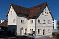
Attractions

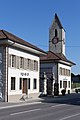
The Schöftland Castle was built in the 1660th In the Middle Ages, there was a small castle tower in the same place, which was destroyed in the Sempach War. The castle has been owned by the community since 1917 and serves as the seat of the local government. The Reformed Church was built in 1506 in the late Gothic style. In 1683 the nave was destroyed by fire and then rebuilt in a baroque style. The choir and the church tower to the north have been preserved . 1979–1980 Walter Moser established the Catholic Church of the Holy Family .
The RapidMuseum , which opened in 2010, shows around 80 Rapid motor mowers in the Lüscher-Schüür, which was specially converted for this purpose , from its origins in 1926 to the present day.

lock

reformed Church

Reformed rectory
Salt Peter House
Two guard houses by the castle


coat of arms
The blazon of the municipal coat of arms reads: "In yellow, red St. Andrew's cross." In the illustrated chronicles of the 16th and 17th centuries, Schöftland was mistakenly assigned the coat of arms of the Lords of Hattstatt from Alsace , which has been documented since 1340 , even though they had no connection with the village.
population
The population developed as follows:
| year | 1850 | 1900 | 1930 | 1950 | 1960 | 1970 | 1980 | 1990 | 2000 | 2010 |
| Residents | 1243 | 1323 | 1869 | 2316 | 2698 | 2709 | 2755 | 2736 | 3271 | 3715 |
On December 31, 2019, 4431 people lived in Schöftland, the proportion of foreigners was 16.7%. In the 2015 census, 42.5% described themselves as Reformed and 23.8% as Roman Catholic ; 33.7% were non-denominational or of other faiths. In the 2000 census, 89.5% said their main language was German , 3.7% Italian and 3.0% Albanian .
Politics and law
The assembly of those entitled to vote, the municipal assembly , exercises legislative power. The executing authority is the five-member municipal council . He is elected by the people in the majority procedure, his term of office is four years. The parish council leads and represents the parish. To this end, it implements the resolutions of the municipal assembly and the tasks assigned to it by the canton. The Kulm District Court is the first instance responsible for legal disputes . Schöftland belongs to the Friedensrichterkreis IX (Unterkulm).
economy
According to the company structure statistics (STATENT) collected in 2015, Schöftland has around 1700 jobs, of which 2% are in agriculture, 23% in industry and 75% in the service sector. The industrial companies are small and medium-sized companies in the fields of textiles, mechanical engineering, metal and wood processing, structural and civil engineering as well as in the graphic industry. The largest employer in the service sector is the public sector, such as the school with the regional upper level and the Suhrental senior citizens' center; retailers, banks and insurance companies as well as consulting and health service providers offer additional jobs. Schöftland is the regional center of the middle Suhrental and therefore has numerous commuters from the surrounding communities. Many employees who live in Schöftland themselves are commuters and work in Aarau and the surrounding area.
traffic
The community is well developed. It is located on Hauptstrasse 24 between Aarau and Sursee . Other important roads lead into the Ruedertal , into the Uerkental and over the Böhlerpass to Unterkulm . A bypass road runs west of the village, which also serves as a feeder to the Aarau-West connection to the A1 motorway . Schöftland station is the southern terminus of the Suhrentalbahn to Aarau; There is another stop on Nordweg. From the train station there are postbus lines to Schmiedrued and Sursee train station, as well as a bus line to Zofingen train station . On weekends, a night bus runs from Aarau train station via Schöftland to Kölliken .
education
The community has two kindergartens and four school buildings in which all levels of compulsory elementary school can be completed ( primary school , secondary school , secondary school and district school ). The closest grammar schools are the Alte Kantonsschule and the Neue Kantonsschule , both in Aarau .
Personalities
- Sylvia Flückiger-Bäni (* 1952), politician
- Reto Gloor (1962–2019), comic artist
- Friedrich Wilhelm Knoebel (1802–1871), educator and publicist, was rector of the Schöftland district school from 1847–1860
- Fridolin Laager (1883–1975), politician
- Carl Friedrich Rudolf May (1768–1846), politician
literature
- Markus Widmer-Dean: Schöftland. In: Historical Lexicon of Switzerland .
- Michael Stettler : The art monuments of the canton of Aargau . Ed .: Society for Swiss Art History . Volume I: The districts of Aarau, Kulm, Zofingen. Wiese Verlag, Basel 1948, DNB 366495623 .
Web links
Individual evidence
- ↑ Cantonal population statistics 2019. Department of Finance and Resources, Statistics Aargau, March 30, 2020, accessed on April 2, 2019 .
- ↑ Cantonal population statistics 2019. Department of Finance and Resources, Statistics Aargau, March 30, 2020, accessed on April 2, 2019 .
- ↑ a b Beat Zehnder: The community names of the canton of Aargau . In: Historical Society of the Canton of Aargau (Ed.): Argovia . tape 100 . Verlag Sauerländer, Aarau 1991, ISBN 3-7941-3122-3 , p. 387-388 .
- ^ National map of Switzerland, sheet 1109, Swisstopo.
- ↑ Standard area statistics - municipalities according to 4 main areas. Federal Statistical Office , November 26, 2018, accessed on May 27, 2019 .
- ↑ The first water vortex power plant in Switzerland is being built in the canton of Aargau in Schöftland. Baublatt, October 30, 2009, accessed January 6, 2010 .
- ^ Stettler: The art monuments of the Canton of Aargau, Volume I: The districts of Aarau, Kulm, Zofingen. Pp. 230-231.
- ^ Stettler: The art monuments of the Canton of Aargau, Volume I: The districts of Aarau, Kulm, Zofingen. Pp. 225-229.
- ↑ Rapid Museum
- ^ Joseph Galliker, Marcel Giger: Municipal coat of arms of the Canton of Aargau . Lehrmittelverlag des Kantons Aargau, book 2004, ISBN 3-906738-07-8 , p. 271 .
- ↑ Population development in the municipalities of the Canton of Aargau since 1850. (Excel) In: Eidg. Volkszählung 2000. Statistics Aargau, 2001, archived from the original on October 8, 2018 ; accessed on May 27, 2019 .
- ↑ Resident population by religious affiliation, 2015. (Excel) In: Population and Households, Community Tables 2015. Statistics Aargau, accessed on May 27, 2019 .
- ↑ Swiss Federal Census 2000: Economic resident population by main language as well as by districts and municipalities. (Excel) Statistics Aargau, archived from the original on August 10, 2018 ; accessed on May 27, 2019 .
- ↑ circles of justice of the peace. Canton of Aargau, accessed on June 21, 2019 .
- ↑ Statistics of the corporate structure (STATENT). (Excel, 157 kB) Statistics Aargau, 2016, accessed on May 27, 2019 .