
Leutwil
| Leutwil | |
|---|---|
 |
|
| State : |
|
| Canton : |
|
| District : | Kulm |
| BFS no. : | 4138 |
| Postal code : | 5725 |
| Coordinates : | 655 586 / 240088 |
| Height : | 612 m above sea level M. |
| Height range : | 516–781 m above sea level M. |
| Area : | 3.75 km² |
| Residents: | 761 (December 31, 2019) |
| Population density : | 203 inhabitants per km² |
|
Proportion of foreigners : (residents without citizenship ) |
8.5% (December 31, 2019) |
| Website: | www.leutwil.ch |
_067.JPG) Leutwil |
|
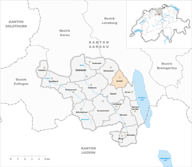
| Location of the municipality | |
  |
|
Leutwil ( Swiss German : Lüpu, ˈlypːʊ ) is a municipality in the Swiss canton of Aargau . It belongs to the Kulm district and is located on the western edge of the Seetal .
geography
The elongated village lies on a plateau between the Seetal and the Homberg range of hills, in the area of a lateral moraine that was formed during the Würme Ice Age when the Reuss Glacier retreated . The plateau is drained by two small brooks that flow into Lake Hallwil just under two kilometers to the east . In the south and southwest the terrain rises steeply to Egg ( 781 m above sea level ) and to Wandfluh ( 766 m above sea level ).
The area of the municipality is 375 hectares , of which 145 hectares are forested and 43 hectares are built over. The highest point is at 781 meters on the summit of the Egg, the lowest at 510 meters on the border with Boniswil . Neighboring communities are Dürrenäsch in the northwest, Boniswil in the northeast, Birrwil in the southeast and Zetzwil in the southwest.
history

The area was already in the 1st century BC. Settled as a Celtic child's grave. Today's village goes back to the founding of the Alemanni . The village name comes from the Old High German Liutinwilari , which means “Liuto's court settlement”. Lutwile was first mentioned on July 2, 1273, when Schönenwerd Abbey ceded a meadow to the village church. In the same year blood jurisdiction changed from the Counts of Kyburg to the Habsburgs . The lords of Trostburg were the owners of the lower jurisdiction .
In 1415 the confederates conquered Aargau. Leutwil now belonged to the subject area of the city of Bern , the so-called Bernese Aargau . In 1528 the Bernese introduced the Reformation . The lordship of Trostburg came into the possession of the Lords of Reinach in 1346 , and in 1486 it fell to the Hallwyler . In 1616 they sold their property to the city of Brugg . However, Bern did not tolerate the increase in power of its subject city and took over the rights of rule. Leutwil then formed part of the Trostburg judicial district within the Lenzburg office . In the years 1628/29 149 people fell victim to a plague epidemic . Around 1720, cotton weaving began to establish itself, which was operated by the farmers in home work .
In March 1798 the French took Switzerland, ousted the «Gracious Lords» of Bern and proclaimed the Helvetic Republic . Since then, Leutwil has belonged to the canton of Aargau. The manual production was replaced by the machine processing around 1840. At the end of the 19th century, several cigar factories were built , most of which had to close in the crisis years during the Second World War; the last representative of the tobacco industry stopped production in 1990. The population stagnated for almost the entire 20th century. However, due to increased construction activity, it has risen by almost forty percent since 1980.
Attractions

The first mention of the reformed church , which stands on a moraine slope sloping down on three sides, was made in 1273. After Dürrenäsch was included in the parish, the nave on the west side had to be extended. The apse was demolished in 1897, at the same time the church was expanded to the east and a new tower was built on the south side. During the renovation in 1937, frescoes from the 13th to 15th centuries of art historical value came to light. Two 17th century plague coffins are kept in the church.
coat of arms
The blazon of the municipal coat of arms reads: "In blue and white bell." This talking coat of arms ( folk etymologically derived from the word läuten ) was created due to a misinterpretation of the village name and was first seen in 1748 on a wooden ceiling in the Leutwil church. In 1957, the local council made the current shape of the bell, in profile and with a recognizable clapper, binding.
population
The population developed as follows:
| year | 1653 | 1850 | 1900 | 1930 | 1950 | 1960 | 1970 | 1980 | 1990 | 2000 | 2010 |
| Residents | 225 | 790 | 599 | 563 | 533 | 521 | 584 | 509 | 562 | 662 | 743 |
On December 31, 2019, 761 people lived in Leutwil, the proportion of foreigners was 8.5%. In the 2015 census, 53.2% described themselves as Reformed and 14.3% as Roman Catholic ; 32.5% were non-denominational or of other faiths. In the 2000 census, 96.7% said their main language was German and 1.1% English .
Politics and law
The assembly of those entitled to vote, the municipal assembly , exercises legislative power. The executing authority is the five-member municipal council . He is elected by the people in the majority procedure, his term of office is four years. The parish council leads and represents the parish. To this end, it implements the resolutions of the municipal assembly and the tasks assigned to it by the canton. The Kulm District Court is the first instance responsible for legal disputes . Leutwil belongs to the Friedensrichterkreis IX (Unterkulm).
economy
According to the corporate structure statistics (STATENT) collected in 2015, there are around 200 jobs in Leutwil, 24% of them in agriculture, 38% in industry and 38% in the service sector. The most important companies are two companies that specialize in apparatus engineering and the manufacture of textile printing machines. Most of the employed are commuters and work in the larger localities in the area or in the Aarau / Lenzburg region .
traffic
The village is somewhat off the main traffic axes, but is connected to the Wynental and Seetal by well-developed side roads . The connection to the network of public transport by bus Teufenthal - Seengen - Lenzburg society Region Lenzburg .
education
_075.JPG)
The community has a kindergarten and a school house where primary school is taught. All upper levels of the compulsory elementary school ( junior high school , secondary school , district school ) can be attended in Seengen . The closest grammar schools are the Alte Kantonsschule and the Neue Kantonsschule , both in Aarau .
Personalities
- Christian Baumann , gymnast (* 1995)
literature
- Hans Walti: Leutwil. In: Historical Lexicon of Switzerland .
- Michael Stettler : The art monuments of the canton of Aargau . Ed .: Society for Swiss Art History . Volume I: The districts of Aarau, Kulm, Zofingen. Wiese Verlag, Basel 1948, DNB 366495623 .
Web links
Individual evidence
- ↑ Cantonal population statistics 2019. Department of Finance and Resources, Statistics Aargau, March 30, 2020, accessed on April 2, 2019 .
- ↑ Cantonal population statistics 2019. Department of Finance and Resources, Statistics Aargau, March 30, 2020, accessed on April 2, 2019 .
- ↑ a b Beat Zehnder: The community names of the canton of Aargau . In: Historical Society of the Canton of Aargau (Ed.): Argovia . tape 100 . Verlag Sauerländer, Aarau 1991, ISBN 3-7941-3122-3 , p. 253-254 .
- ^ National map of Switzerland, sheet 1110, Swisstopo.
- ↑ Standard area statistics - municipalities according to 4 main areas. Federal Statistical Office , November 26, 2018, accessed on May 23, 2019 .
- ^ Stettler: The art monuments of the Canton of Aargau, Volume I: The districts of Aarau, Kulm, Zofingen. Pp. 203-208.
- ^ Joseph Galliker, Marcel Giger: Municipal coat of arms of the Canton of Aargau . Lehrmittelverlag des Kantons Aargau, book 2004, ISBN 3-906738-07-8 , p. 203 .
- ↑ Population development in the municipalities of the Canton of Aargau since 1850. (Excel) In: Eidg. Volkszählung 2000. Statistics Aargau, 2001, archived from the original on October 8, 2018 ; accessed on May 23, 2019 .
- ↑ Resident population by religious affiliation, 2015. (Excel) In: Population and Households, Community Tables 2015. Statistics Aargau, accessed on May 23, 2019 .
- ↑ Swiss Federal Census 2000: Economic resident population by main language as well as by districts and municipalities. (Excel) Statistics Aargau, archived from the original on August 10, 2018 ; accessed on May 23, 2019 .
- ↑ circles of justice of the peace. Canton of Aargau, accessed on June 21, 2019 .
- ↑ Statistics of the corporate structure (STATENT). (Excel, 157 kB) Statistics Aargau, 2016, accessed on May 23, 2019 .