
Birrwil
| Birrwil | |
|---|---|
 |
|
| State : |
|
| Canton : |
|
| District : | Kulm |
| BFS no. : | 4132 |
| Postal code : | 5708 |
| Coordinates : | 657 307 / 237982 |
| Height : | 556 m above sea level M. |
| Height range : | 449–771 m above sea level M. |
| Area : | 3.41 km² |
| Residents: | 1148 (December 31, 2019) |
| Population density : | 337 inhabitants per km² |
|
Proportion of foreigners : (residents without citizenship ) |
15.2% (December 31, 2019) |
| Website: | www.birrwil.ch |
 View from Hallwilersee to Birrwil |
|
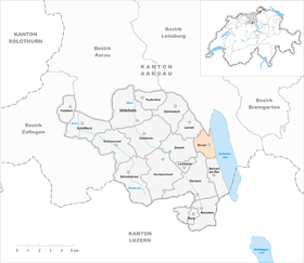
| Location of the municipality | |
  |
|
Birrwil (in the local Swiss German dialect ˈberbʊ ) is a municipality in the Swiss canton of Aargau . It belongs to the Kulm district and is located in the Seetal on the west bank of Lake Hallwil .
geography
The village is located on four long, narrow terraces on the steep eastern slopes of the Eichhalde ( 771 m above sea level ) and the Güggeliberg ( 752 m above sea level ), around 70 to 150 meters above sea level. A small plateau stretches between the two hills and is bordered in the west by the almost circular Tatschbüel hill ( 715 m above sea level ). With the exception of the hamlet “Am See”, the shores of Lake Hallwil are largely undeveloped. Right in the northeast, near Alliswil , is the Schwaderhof hamlet.
The area of the municipality is 341 hectares , of which 97 hectares are forested and 51 hectares are built over. The highest point is at 771 meters on the Eichhalde, the lowest at 449 meters on the lake shore. Neighboring communities are Leutwil in the north-west, Boniswil in the north, Meisterschwanden in the east, Beinwil am See in the south, Reinach in the south-west and Zetzwil in the west.
history
Isolated finds testify to a settlement during the Neolithic . The eastern slope of the Homberg also seems to have been inhabited during Roman times, as is shown by remains of wall remains, brick stamps and a coin belonging to Emperor Claudius Gothicus (approx. 270 AD). The village was founded by the Alamanni , as can be seen from individual finds. Beriuuillare was first mentioned in a document in 1185. The place name goes back to the Old High German Berinwilari , which means "court settlement of Bero".
In the Middle Ages the village was under the rule of the Counts of Lenzburg , from 1173 on that of the Counts of Kyburg . After these died out, the Habsburgs took over sovereignty and blood jurisdiction in 1273 . The Lords of Birrwil ruled the village in the name of these noble houses. The family attested since 1185 had only local significance and died out in 1331, nothing of their castle has survived. From 1326, the respective owners of practicing Castle Liebegg at Graenichen the lower jurisdiction from. The Lords of Hallwyl owned a small stretch of shore (Dingstätte), as a document from 1419 attests. This is where the Maritime Tribunal met over Lake Hallwil.

In 1415 the confederates conquered Aargau. Birrwil now belonged to the subject area of the city of Bern , the so-called Berner Aargau . The village formed a judicial district in the Lenzburg district . In 1528 the Bernese introduced the Reformation . Cotton processing was established during the 18th century . In March 1798 the French took Switzerland, ousted the «Gracious Lords» of Bern and proclaimed the Helvetic Republic . Since then, Birrwil has belonged to the canton of Aargau. The integration of the former Steckhöfe took place relatively late : the Schwaderhof belonged to the then independent municipality of Alliswil until 1822 , the Wilhof was not fully integrated into the municipality of Birrwil until 1905.
Seetalstrasse was opened in 1852, and the first cigar factory was founded five years later . On October 15, 1883, Birrwil was connected to the railway network when the Seetalbahn opened the section between Beinwil am See and Lenzburg. By 1930 the population had declined by over a fifth and then stagnated for a long time before it began to rise significantly at the beginning of the 21st century. The tobacco industry has disappeared since 1960 and agriculture is also of little importance. Birrwil has developed into a residential community that is based on the larger regional centers.
Attractions

The Birrwil Church was first mentioned in 1275 and was consecrated to Our Lady. In 1689 the nave with the exception of the north wall was demolished and a new building was built a few meters further north. The remaining north wall now formed the south side. The medieval church tower attached to the choir was preserved. In 1791 the church was given a stucco ceiling in the Rococo style. Extensive renovations were carried out in 1925 and 1975/78. Farmhouses with high hipped roofs in the Bernese style characterize the townscape.
coat of arms
The blazon of the municipal coat of arms reads: "In blue over a green three-mountain, white pear on a green branch of leaves." The coat of arms first appeared on the cover of the church sled from 1513, the use of the pear is due to a misinterpretation of the place name. In order to avoid confusion with the coat of arms of Birr , the local council changed the color of the pear from yellow to white in 1953.
population
The population developed as follows:
| year | 1653 | 1850 | 1900 | 1930 | 1950 | 1960 | 1970 | 1980 | 1990 | 2000 | 2010 |
| Residents | 195 | 972 | 850 | 808 | 845 | 880 | 888 | 927 | 923 | 960 | 948 |
On December 31, 2019, 1148 people lived in Birrwil, the proportion of foreigners was 15.2%. In the 2015 census, 40.1% described themselves as Reformed and 19.4% as Roman Catholic ; 40.5% were non-denominational or of other faiths. In the 2000 census, 93.6% stated German as their main language, 1.1% Albanian and 0.8% each Italian and French .
Politics and law
The assembly of those entitled to vote, the municipal assembly , exercises legislative power. The executing authority is the five-member municipal council . He is elected by the people in the majority procedure, his term of office is four years. The parish council leads and represents the parish. To this end, it implements the resolutions of the municipal assembly and the tasks assigned to it by the canton. The Kulm District Court is the first instance responsible for legal disputes . Birrwil belongs to the Friedensrichterkreis IX (Unterkulm).
economy
According to the corporate structure statistics (STATENT) collected in 2015, there are around 270 jobs in Birrwil, 9% of them in agriculture, 10% in industry and 81% in the service sector. In addition to a few commercial and service companies, tourism is also of certain importance (excursion traffic on Lake Hallwil). Most of the employed are commuters and work in the upper Wynental ( Reinach / Menziken ).
traffic
The main road 26 runs through the village from Lenzburg via Hochdorf to Lucerne . Birrwil has a stop on the Seetalbahn of the SBB . There is also a ship landing stage for the Hallwilersee shipping company .
education
The community has a kindergarten and a school house where primary school is taught. All upper levels ( Realschule , Secondary School and District School ) can be attended in Reinach . The closest grammar schools are the Alte Kantonsschule and the Neue Kantonsschule , both in Aarau .
literature
- Hans Walti: Birrwil. In: Historical Lexicon of Switzerland .
- Michael Stettler : The art monuments of the canton of Aargau . Ed .: Society for Swiss Art History . Volume I: The districts of Aarau, Kulm, Zofingen. Wiese Verlag, Basel 1948, DNB 366495623 .
- Willi Hintermann: Birrwil, 1185-1985: a little village story. Birrwil 1985.
Web links
Individual evidence
- ↑ Cantonal population statistics 2019. Department of Finance and Resources, Statistics Aargau, March 30, 2020, accessed on April 2, 2019 .
- ↑ Cantonal population statistics 2019. Department of Finance and Resources, Statistics Aargau, March 30, 2020, accessed on April 2, 2019 .
- ↑ a b Beat Zehnder: The community names of the canton of Aargau . In: Historical Society of the Canton of Aargau (Ed.): Argovia . tape 100 . Verlag Sauerländer, Aarau 1991, ISBN 3-7941-3122-3 , p. 94-95 .
- ^ National map of Switzerland, sheet 1110, Swisstopo.
- ↑ Standard area statistics - municipalities according to 4 main areas. Federal Statistical Office , November 26, 2018, accessed on May 23, 2019 .
- ^ Martin Hartmann, Hans Weber: The Romans in Aargau . Verlag Sauerländer, Aarau 1985, ISBN 3-7941-2539-8 , p. 165 .
- ^ Joseph Galliker, Marcel Giger: Municipal coat of arms of the Canton of Aargau . Lehrmittelverlag des Kantons Aargau, book 2004, ISBN 3-906738-07-8 , p. 123 .
- ↑ Population development in the municipalities of the Canton of Aargau since 1850. (Excel) In: Eidg. Volkszählung 2000. Statistics Aargau, 2001, archived from the original on October 8, 2018 ; accessed on May 23, 2019 .
- ↑ Resident population by religious affiliation, 2015. (Excel) In: Population and Households, Community Tables 2015. Statistics Aargau, accessed on May 23, 2019 .
- ↑ Swiss Federal Census 2000: Economic resident population by main language as well as by districts and municipalities. (Excel) Statistics Aargau, archived from the original on August 10, 2018 ; accessed on May 23, 2019 .
- ↑ circles of justice of the peace. Canton of Aargau, accessed on June 21, 2019 .
- ↑ Statistics of the corporate structure (STATENT). (Excel, 157 kB) Statistics Aargau, 2016, accessed on May 23, 2019 .