
Uerke
| Uerke | ||
 Uerke below Bottenwil |
||
| Data | ||
| Water code | CH : 538 | |
| location |
Mittelland
|
|
| River system | Rhine | |
| Drain over | Suhre → Aare → Rhine → North Sea | |
| source | in the hills between Reiden and Winikon 47 ° 13 ′ 57 ″ N , 8 ° 1 ′ 29 ″ E |
|
| Source height | 688 m above sea level M. | |
| muzzle | near Unterentfelden in the Suhre Coordinates: 47 ° 21 '54 " N , 8 ° 3' 3" E ; CH1903: 646 247 / 246194 47 ° 21 '54 " N , 8 ° 3' 3" O |
|
| Mouth height | 406 m above sea level M. | |
| Height difference | 282 m | |
| Bottom slope | 16 ‰ | |
| length | 17.4 km | |
| Catchment area | 41.12 km² | |
| Discharge at the Holziken A Eo gauge : 25.1 km² Location: 5.6 km above the mouth |
MNQ 1979–2014 MQ 1979–2014 Mq 1979–2014 MHQ 1979–2014 HHQ (1994) |
260 l / s 410 l / s 16.3 l / (s km²) 5.4 m³ / s 9.2 m³ / s |
| Left tributaries | Köllikerbach | |
The Uerke (sometimes also spelled Ürke ) is a 17 km long left tributary of the Suhre in the Swiss cantons of Lucerne and Aargau . After the Wyna, it is the most important tributary of the Suhre and has a catchment area of around 41 square kilometers.
geography
course
The Uerke rises at 688 meters in the Lättewald between Reiden and Winikon in the municipality of Triengen in the canton of Lucerne.
After about a kilometer and a half, it forms the border between the two cantons. It now flows mostly in a north-westerly direction through the narrow Uerkental , whose valley floor is nowhere wider than 250 meters. Shortly before Bottenwil , it passes over entirely to Aargau soil. It now flows in a north-easterly direction through Bottenwil, Uerkheim and Holziken , where the valley spreads out into a flat plain over three kilometers wide. It is now largely straightened, touches Kölliken in the east and only a little later begins its most important tributary with the Köllikerbach .
The Uerke now flows through Unterentfelden and finally flows into the Suhre at an altitude of 406 meters.
Catchment area
The 41.12 km² catchment area of the Uerke is drained through it via the Suhre, Aare and Rhine to the North Sea.
It consists of 48.1% wooded area , 37.3% agricultural area , 14.3% settlement area and 0.3% unproductive areas.
The area distribution

The mean height of the catchment area is 536.5 m above sea level. M. , the minimum height is 406 m above sea level. M. and the maximum height at 759 m above sea level. M.
Tributaries
- Etzelgraben ( right ), 1.2 km
- Geisswegbach ( right ), 0.2 km
- Einwegbächli ( right ), 0.7 km
- Wickisgraben ( right ), 0.5 km
- Stockgraben ( right ), 0.6 km
- Lehgraben ( left )
- Tannholzbächli ( right )
- Bodenmattbächli ( right )
- Hornibächli ( right )
- Tanngraben ( left )
- Schüppisbächli ( left )
- Hundslochbach ( left )
- Sulbach ( right )
- Schäferenbächli ( right )
- Mountain stream ( left )
- Katzenhaldenbächli ( left )
- Schäferenbächli ( right )
- Stickelbächli ( left )
- (Brook from) Stampfental ( right )
- Stelzenbächli ( left )
- Fluhbächli ( right )
- Hinterwilerbach ( left )
- (Bach from) Bändlirain ( right )
- Obermatten Canal ( left )
- Köllikerbach ( left )
- Tannbächlein ( left )
- Löliacher (Bach) ( left )
- Frohmattbächlein ( left )
Hydrology
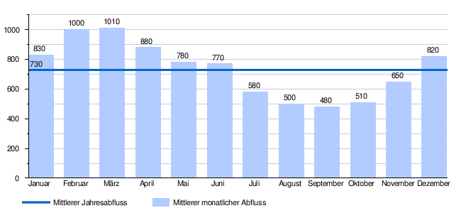
At the confluence of the Uerke in the Suhre, its modeled annual mean flow rate (MQ) is 730 l / s. Her discharge regime type is pluvial inférieur and her discharge variability is 25.
Individual evidence
- ↑ a b Geoserver of the Swiss Federal Administration ( information )
- ↑ Hydrological Atlas of Switzerland of the Federal Office for the Environment FOEN, Table_13
- ↑ Modeled mean annual discharge. In: Topographical catchment areas of Swiss waters: sub-catchment areas 2 km². Retrieved August 30, 2017 .
- ^ Hydrometry of the canton of Aargau
- ↑ Topographic catchment areas of Swiss waters: Uerke , Federal Office for the Environment FOEN
- ↑ "Hidden behind the mean values" - the variability of the discharge regime , p. 7
- ↑ The discharge variability describes the extent of the fluctuations in the mean discharge of individual years around the long-term mean discharge value.
- ↑ Average discharge and discharge regime type for the water network in Switzerland: Uerke , Federal Office for the Environment FOEN