Hallwil
| Hallwil | |
|---|---|
| State : |
|
| Canton : |
|
| District : | Lenzburg |
| BFS no. : | 4197 |
| Postal code : | 5705 |
| Coordinates : | 655 811 / 242137 |
| Height : | 475 m above sea level M. |
| Height range : | 440-550 m above sea level M. |
| Area : | 2.18 km² |
| Residents: | 877 (December 31, 2019) |
| Population density : | 402 inhabitants per km² |
|
Proportion of foreigners : (residents without citizenship ) |
19.3% (December 31, 2019) |
| Website: | www.hallwil.ch |
|
Hallwil |
|
| Location of the municipality | |
Hallwil (in the local dialect Haubu, derhɑʊbʊ ) is a municipality in the Swiss canton of Aargau . It belongs to the Lenzburg district and is located almost seven kilometers south of the district capital in the Seetal . The place name Niederhallwil existed from 1566 to 1950 , but only in official use.
geography
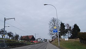
The street village extends along the western edge of the Seetal. However, it is not located on Lake Hallwil , but just under two kilometers from its northern end on a moraine . To the west of the village center, the terrain rises steeply to the Dürrenäsch plateau . The canalised Aabach in the middle of the Seetal plain, which flows in a northwesterly direction around 400 meters from the village, forms the eastern boundary of the municipality.
The area of the municipality is 218 hectares , of which 24 hectares are forested and 46 hectares are built over. The highest point is at 560 m above sea level. M. on the southeastern boundary of the municipality, the deepest at 442 m above sea level. M. am Aabach. Neighboring communities are Seon in the north, Seengen in the east, Boniswil in the south and Dürrenäsch in the west.
history
Allewilare was first mentioned in a document in 1167. The place name comes from the Old High German Hallinwilari and means "Hofsiedlung des Hallo". In the Middle Ages the village was under the rule of the Counts of Lenzburg , from 1173 on that of the Counts of Kyburg . After these were extinct, the Habsburgs took over sovereignty and blood jurisdiction in 1273 . The lower jurisdiction was in the possession of the Lords of Reinach .
In 1415 the confederates conquered Aargau. Hallwil now belonged to the subject area of the city of Bern , the so-called Berner Aargau . The village was part of the Trostburg judicial district in the Lenzburg district . This district was owned by the Hallwyler from 1486 to 1616 and then also came to Bern. The Bernese introduced the Reformation in 1528, and the village has belonged to the Seengen parish ever since . In March 1798 the French took Switzerland, ousted the «Gracious Lords» of Bern and proclaimed the Helvetic Republic . Hallwil has been part of the canton of Aargau since then.
In the 18th and 19th centuries, apart from agriculture, home work for silk ribbon and linen weaving was widespread. The first cigar factory was founded in 1864 . On October 15, 1883, the community was connected to the railway network when the Lenzburg– Beinwil am See section of the Seetalbahn was opened. The last representative of the tobacco industry closed its doors in 1971.
Attractions
coat of arms
The blazon of the municipal coat of arms reads: "In red on a green three-mountain, green palm with yellow fruits." Even the municipal seals of the 19th century clearly show a palm tree. It is not known whether and why there is a connection between the former farming village and this exotic plant. In 1963 the color of the escutcheon was changed from yellow to red.
Culture
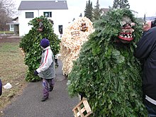
Various customs are practiced in Hallwil, which were previously common in other parts of the Canton of Aargau. The Customs Commission under the supervision of the municipality (formerly “Association for the Preservation of Old Folk Customs”) ensures that these old traditions are preserved. From November 11th ( Martin's Day ) to January 2nd, five Seetal winter customs are celebrated in a short time : These are Chlauschlöppen , Chlausjagen , Wienachts-Chindli , Silväschtertrösche and Bärzeli . In particular, the Bärzeli custom on Berchtold's Day is known far beyond the region.
population
The population developed as follows:
| year | 1798 | 1850 | 1900 | 1930 | 1950 | 1960 | 1970 | 1980 | 1990 | 2000 | 2010 |
| Residents | 396 | 428 | 387 | 443 | 508 | 544 | 577 | 516 | 647 | 721 | 773 |
On December 31, 2019, 877 people lived in Hallwil, the proportion of foreigners was 19.3%. In the 2015 census, 38.1% described themselves as Reformed and 20.6% as Roman Catholic ; 41.3% were non-denominational or of other faiths. In the 2000 census, 89.5% said their main language was German , 3.5% Albanian and 3.2% Italian .
Politics and law
The assembly of those entitled to vote, the municipal assembly , exercises legislative power. The executing authority is the five-member municipal council . He is elected by the people in the majority procedure, his term of office is four years. The parish council leads and represents the parish. To this end, it implements the resolutions of the municipal assembly and the tasks assigned to it by the canton. The District Court of Lenzburg is the first instance responsible for legal disputes . Hallwil belongs to the Friedensrichterkreis XII (Seon).
economy
According to the company structure statistics (STATENT) collected in 2015, Hallwil has around 240 jobs, 6% of them in agriculture, 42% in industry and 52% in the service sector. Small businesses in the service sector and apparatus engineering are predominant. Most of the employed are commuters and work in the local area (mainly in Seon and Lenzburg ).
traffic
The main road 26 runs through the village from Lenzburg via Hochdorf to Lucerne . Kantonsstrasse 250 leads via Dürrenäsch into Wynental . Hallwil has a stop on the Seetalbahn of the SBB .
education
The community has a kindergarten and a schoolhouse where primary school is taught up to fourth grade. The fifth and sixth grade of primary school as well as all upper grades ( Realschule , Secondary School , District School ) can be attended in Seengen . The closest grammar schools are the Alte Kantonsschule and the Neue Kantonsschule , both in Aarau .
Personalities
- Andreas Aeschbach (* 1970), racing cyclist
- Rudolf Urech (1815–1872), National and Government Councilor
literature
- Hans Walti: Hallwil (community). In: Historical Lexicon of Switzerland .
- Michael Stettler , Emil Maurer : The art monuments of the canton of Aargau . Ed .: Society for Swiss Art History . Volume II: The districts of Lenzburg, Brugg. Wiese Verlag, Basel 1953, DNB 750561750 .
Web links
Individual evidence
- ↑ Cantonal population statistics 2019. Department of Finance and Resources, Statistics Aargau, March 30, 2020, accessed on April 2, 2019 .
- ↑ Cantonal population statistics 2019. Department of Finance and Resources, Statistics Aargau, March 30, 2020, accessed on April 2, 2019 .
- ↑ a b Beat Zehnder: The community names of the canton of Aargau . In: Historical Society of the Canton of Aargau (Ed.): Argovia . tape 100 . Verlag Sauerländer, Aarau 1991, ISBN 3-7941-3122-3 , p. 186-188 .
- ^ National map of Switzerland, sheets 1090 and 1110, Swisstopo.
- ↑ Standard area statistics - municipalities according to 4 main areas. Federal Statistical Office , November 26, 2018, accessed on May 20, 2019 .
- ^ Joseph Galliker, Marcel Giger: Municipal coat of arms of the Canton of Aargau . Lehrmittelverlag des Kantons Aargau, book 2004, ISBN 3-906738-07-8 , p. 170 .
- ↑ Population development in the municipalities of the Canton of Aargau since 1850. (Excel) In: Eidg. Volkszählung 2000. Statistics Aargau, 2001, archived from the original on October 8, 2018 ; accessed on May 20, 2019 .
- ↑ Resident population by religious affiliation, 2015. (Excel) In: Population and Households, Community Tables 2015. Statistics Aargau, accessed on May 20, 2019 .
- ↑ Swiss Federal Census 2000: Economic resident population by main language as well as by districts and municipalities. (Excel) Statistics Aargau, archived from the original on August 10, 2018 ; accessed on May 20, 2019 .
- ↑ circles of justice of the peace. Canton of Aargau, accessed on June 21, 2019 .
- ↑ Statistics of the corporate structure (STATENT). (Excel, 157 kB) Statistics Aargau, 2016, accessed on May 20, 2019 .


