
Región del Libertador General Bernardo O'Higgins
| Libertador General Bernardo O'Higgins Region VI
O'Higgins |
|||
|---|---|---|---|
  |
|||
| Symbols | |||
|
|||
| Basic data | |||
| Country | Chile | ||
| Capital | Rancagua | ||
| surface | 16,387 km² | ||
| Residents | 914,555 (2017 census) | ||
| density | 56 inhabitants per km² | ||
| ISO 3166-2 | CL-LI | ||
| Website | www.dellibertador.cl | ||
| politics | |||
| Intendant | Pablo Silva Amaya | ||
.jpg) |
|||


Coordinates: 34 ° 30 ′ S , 71 ° 0 ′ W
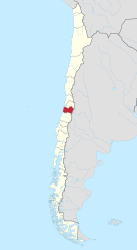
The VI Libertador General Bernardo O'Higgins region is located in Chile around 50 km south of Santiago de Chile . It is named after the first Director Supremo of Chile, Bernardo O'Higgins .
Geography and climate
In the north the region borders on Region V ( Región de Valparaíso ) and the capital region , in the south on Region VII ( Región del Maule ). The capital of the region is Rancagua .
Region VI consists of 3 provinces:
- Cachapoal Province , capital Rancagua
- Colchagua Province , capital of San Fernando
- Cardenal Caro Province , capital Pichilemu
Most important cities / places:
- Rancagua , 212,696 inhabitants (as of 2005)
- San Fernando , 52,551 inhabitants (as of 2005)
- Santa Cruz , 32,000 inhabitants
- Pichilemu , 12,000 inhabitants
- Sewell , ghost town of the El Teniente copper mine
In the north-west of the region lies the large Lago Rapel reservoir with around 80 km². In the Andes, numerous rivers feed the region. B. the Río Cachapoal and the Río Tinguiririca .
There are also 2 large volcanoes here, the Tinguiririca 4280 m and the El Palomo 4860 m. The Tinguiririca fauna is also associated with the Tinguiririca ; the bone finds go back to mammals that died a little more than 30 million years ago in volcanic eruptions of the Tinguiririca.
The climate is Mediterranean, around Rancagua there is an average of 450 mm of rain / year.
history
The Incas settled in a place called Copequén near Rancagua . This settlement was subordinate to the Inca in Cuzco .
The conquistador Alonso de Córdova started producing clothing and other handicrafts in Rancagua early on. In 1580 it was decided to form a kind of city with the doctrine of Rancagua. A church was built and later a cathedral in the same place. By 1625 the number of Spanish settlers had already increased significantly.
1687 a descendant dies of Alonso de Córdova and 152 Native obtain land rights, the cacique 's Tomás Guaglen. In 1711 the Spaniards set up a small military base in the city.
In 1743 Juan Francisco de Arrechea began the systematic planning and organization of the urban area based on the model of the city of Santa Cruz . Governor José Antonio Manso de Velasco founded the city on October 5, 1743. The city rights were officially granted on July 29, 1749.
In the Battle of Rancagua , Spain was victorious on October 2, 1814 over Bernardo O'Higgins and José Miguel Carrera .
tourism

.jpg)
Region VI has large wine-growing areas that can be visited via the La Ruta del Vino wine route . The wineries are located in the Cachapoal and Colchagua valleys. To the east is the largest underground copper mine in the world, El Teniente, with its emblematic ghost town of Sewell . About 30 km east of Rancagua are the thermal springs Thermas de Cauquenes . To the south of it lie the cypress forests of the Río de los Cipreses national reserve .
In the northwest lies the large reservoir Lago Rapel , which is ideal for excursions. The port city of Pichilemu is a well-known surfing and bathing area.
18km south of San Fernando is the town of Chimbarongo , famous for weaving of wicker willow is.
economy
In the Andes near Rancagua lies the largest underground copper mine in the world, called El Teniente . It represents around 20% of Chilean copper production. Agriculture and tourism also play an important role.
Agriculture mainly grows wine and fruit . The city of Rancagua is famous for its textile industry.
Web links
I. Región de Tarapacá | II. Región de Antofagasta | III. Atacama Region | IV. Región de Coquimbo | V. Región de Valparaíso | VI. Región del Libertador General Bernardo O'Higgins | VII. Región del Maule | VIII. Región del Biobío | IX. Región de la Araucanía | X. Región de los Lagos | XI. Región de Aysén del General Carlos Ibáñez del Campo | XII. Región de Magallanes y de la Antártica Chilena | XIV. Región de Los Ríos | XV. Región de Arica y Parinacota | XVI. Región de Ñuble | Metropolitan Region of Santiago