
To the
| Andes (Cordilleras) Cordillera de los Andes |
|
|---|---|
![Relief map of the Andes, generated from satellite images and elevation data[1]](https://de.wikipedia.org/wiki/Datei:Nasa_anden.jpg) Relief map of the Andes, generated from satellite imagery and elevation data |
|
| Highest peak | Aconcagua ( 6961 m ) |
| position | South America |
| part of | American Cordilleras |
| coordinates | 33° S , 70° W |
| Type | Fold mountains with volcanism ( Pacific Ring of Fire ) |
The Andes ( Spanish Cordillera de los Andes , Quechua Anti or Antis ) are ~9600 km long and 7400 km maximum extension, the longest (above sea level) mountain chain on earth and with 42 six-thousanders and over 50 five-thousanders the highest mountains outside Asia. They form the southern part of the American Cordilleras , which are orographically interrupted in Central America.
On the slopes of the tropical Andes are the two largest centers of biological diversity on earth. The central Andes contain extraordinarily large amounts of ores of the most diverse metals. Around 3000 to 2000 BC In the tropical western Andes region one of the four major areas of origin of agriculture as well as the associated oldest American urban culture of Caral in Peru lay. As a result, a number of advanced Andean cultures developed in the Andes region , including the Inca Empire. The most important contribution of Andean cultures to the world community is the potato . In the Andes lie today with La Paz (Bolivia's seat of government, 3600 m), Quito (Ecuador, 2850 m), Sucre (Bolivia's capital, 2808 m) and (after Thimphu , Bhutan in the Himalayas ) Bogotá (Colombia, 2640 m) four of the highest capital cities on earth.
etymology
In general, the term Andes is traced back to the Spanish word "Andenes" (short form "Andes"), which was used by the conquistadors to designate the field cultivation terraces of the Andean slopes. Some etymologists trace this further back to words from the indigenous Kichwa language: the word "andi/anti", which is translated as either "high mountains" or "east", is discussed. The name of the Eastern Cordillera of the Inga Empire "Antisuyu" and its inhabitants, who were called "Antis", also stands in this context. Finally, "anda" (copper) was also discussed, but the metal did not play a significant role in pre-Culumbian times.
location and landscape
The Andes extend along the west coast of South America from Venezuela through Colombia , Ecuador , Peru , Bolivia , Argentina and Chile . With a north-south extension of 7400 kilometers from the tropics (at 10° north) far into the extratropics (at 55° south) they exceed the Rocky Mountains of North America (max. 5100 km) by about half and have almost the double extension of the Himalaya - Karakorum - Hindu Kush system in Asia with its approximately 3800 kilometers. In the south and in Ecuador they are up to 200 km wide. Between Arica (Chile) and Santa Cruz de la Sierra (Bolivia), the east-west extension is over 600 kilometers.
Because of their height, length, and north-south extension, the Andes provide a good example of several types of geographic change .
General outline
.jpg)
The Andes consist of one to three parallel main chains. In the middle section in Peru, Bolivia, northern Chile and northern Argentina, these chains are very widely separated and enclose the central highlands ( Altiplano ) in which Lake Titicaca is embedded.
Compared to the North American Cordilleras, the Andes appear uniformly closed on physical maps. In fact, however, there is a great variety of orographic , topographical and geomorphological forms, which makes it difficult to subdivide, so that there are a number of designs that differ more or less from one another. In addition, some designations (e.g. Cordillera central or Cordillera real ) are used very differently from country to country and do not always correspond to the definitions of geologists.
A widely recognized rough classification was designed by Tanner in 1978 and adapted again by Borsdorf and Stadel in 2013. The adjacent map and the following structure are based on this model.
north andes

Although the lithospheric Cocos Plate forms the Pacific subsurface off Central America, its eastward movement also caused the—much more recent—upfolding of the North Andes (see also Physical Geography of South America#The North Andes ) , which today lie mostly in Colombia and to a lesser extent in Venezuela. They essentially consist of three chains separated by two deep rift valleys.
foothills and coastal mountains
- Caribbean Coast Mountains (Venezuela)
- Cordillera del Chocó (Colombia and Panama)
Western Cordillera ( oceanic crust , volcanism )
Central Cordillera ( Crystalline Complex )
- Sierra Nevada de Santa Marta (Colombia)
- Serrania de San Lucas (Colombia)
- Cordillera Central (Colombia)
Eastern Cordillera ( sedimentary rocks )
- Sierra de Perijá (Colombia, Venezuela)
- Cordillera de Merida (Venezuela)
- Cordillera Oriental (Colombia)
Central Andes
The Central Andes (see also Physical geography of South America#The Central Andes ) - more than two-thirds of the entire mountain system and the second largest mountain block on earth above the 2500 m level line - were directly uplifted by the under- thrusting of the Nazca Plate , which lies in western South America forms the seabed of the Pacific up to 5000 km west. They range from the mountain node Nudo de los Pastos on the northern Ecuadorian border to the Gulf of Ancud in southern Chile. The central Andes - which are in principle extremely rich in ore (see section on raw materials and economy ) - are further subdivided into three areas according to their geomorphological and geological structure:
The northern central Andes - formed by three main ranges except in Ecuador - encompasses all of the Andes of Ecuador and most of Peru up to the mountain node Nudo de Vilcanota on the northern edge of the Altiplano. The Western Cordillera falls very steeply towards the Pacific. Between it and the Central or Eastern Cordillera are either transverse mountain ranges (cuestas) or basins (cuencas) .
The middle central Andes are formed by two chains in southern Peru and by three chains in the area of Bolivia, northern Chile and northern Argentina. Between the western and eastern cordillera lies the high plateau of the Altiplanos. The transition to the southern central Andes is defined very differently in the literature. After Borsdorf and Stadel, the Chilean volcano Llullaillaco marks the southern end of the Altiplano and thus also of the middle central Andes. According to the classification of Argentina's geography , the southern end of the Puna/Altiplano region is at about the level of the Incahuasi volcano .
The southern central Andes - which stretches across the entire border of Chile and Argentina to the beginning of Patagonia - is formed in the north by three chains and a broad hem of foothills, which are often not counted among the actual Andes, although they have a regional high mountain character. From around Santiago de Chile (according to Alonso et al. (2006) border area between the central and southern central Andes), the coastal chain and the eastern Sierren further south break up into several individual mountain ranges with a low mountain range character . The “Western Cordillera”, which is the only chain of the Andes left here, rapidly loses altitude southwards from the more than 6000 m high Aconcagua, only to climb a distance of around 600 km to the Bay of Ancud with only a few peaks of more than 3000 m reach.
Coastal foothills (Middle Mountains)
- Montes de Convento (Ecuador)
- Cordillera Costanera (Ecuador)
- Cordillera de la Costa (Chile)
Western Cordillera (North: extinct and active volcanoes; middle: young volcanoes; south: volcanism, andesite , rift valley )
- Cordillera Occidental (Ecuador)
- Cordillera Occidental (Peru)
- Cordillera Occidental (Bolivia and Chile)
- Cordillera Frontal (Argentina and Chile)
- Cordillera Principal (Argentina and Chile)
Central Cordillera ( Batholith )
Altiplano high basin ( sedimentary deposits )
- Altiplano (Peru, Bolivia)
- Puna (Argentina)
Eastern Cordillera (North: Crystalline ; from middle: Paleozoic to Tertiary with volcanism)
- Cordillera de Cutucu (Ecuador)
- Cordillera Oriental (Peru)
- Cordillera Oriental (Bolivia)
- Cordillera Oriental (Argentina)
- prerecordillera
Eastern Promontory ( Paleozoic )
- Voranden (Bolivia)
- Sierras Subandinas (Argentina)
- Sierras Pampeanas (Argentina)
south andes
The southern Andes - also called the Patagonian Cordillera or Patagonian Andes - (see also Physical geography of South America#The southern Andes ) were raised by the Antarctic Plate , which, however, has much lower tectonics . They consist of a chain, which is preceded by extensive plateaus with very rugged edges in the east and coastal or island cordilleras that are interrupted several times in the west. The actual chain of the Andes (with one exception in the area of the Strait of Magellan ) stretches on both sides along the Argentine-Chilean border is in the southern half with two very large ice fields (Campo de Hielo Sur approx. 13,000 km² and Campo de Hielo Norte approx. 3700 km²). km²) is extremely glaciated and reaches a maximum height of 4058 m with the Monte San Valentín in the north of the Campo de Hielo Norte . The Patagonian Andes are often very steep with large differences in altitude. This results in "fast-flowing" ice, which in turn has led to bizarre glacier towers , but also - in connection with changing weather conditions and erosion - to picturesque peak shapes (such as the famous Torres del Paine ).
Coastal Promontory ( Paleozoic )
(West) Andes Cordillera ( Mesozoic , batholiths, laccoliths , volcanism in the north)
- Patagonian Andes (Chile, Argentina)
- Cordillera Darwin ( Tierra del Fuego , Chile)
Eastern Promontory ( Paleozoic )
- Patagonids (Argentina)
|
|


Formation of the Andes


The Andes are considered a prime example of a mountain range over an ocean-continent subduction zone . In the case of the Andes, oceanic lithosphere of the Nazca Plate and, to a lesser extent, the Antarctic Plate submerges beneath continental lithosphere of the South American Plate . Where the Nazca Plate begins its way under the continental block, there is a deep -sea channel that is divided into the Peru Trench (−6262 m) in the north and the Atacama Trench ( −8066 m) in the south.
Subduction of the Nazca Plate under the South American Plate
The subduction of the Nazca Plate under the South American Plate began no later than about 140 to 150 million years ago ( Upper Jurassic or Lower Cretaceous ), but initially without causing significant deformation processes on the western edge of the South American Plate (so-called upper plate deformation). The beginning of the actual orogeny (mountain formation) is only set for the Eocene (45 mya ). The exact reason for this delay is unknown, but one of the assumptions is that the deceleration of the African plate as Africa collided with Eurasia from the Palaeogene onwards must have caused the South American plate to accelerate westwards, as the rate of opening of the South Atlantic has increased since the collision of Africa has not changed significantly. This acceleration resulted in Nazca-South America convergence rates of up to 15 cm per year, greatly increasing the pressure the two plates are exerting on each other. This is held responsible for the horizontal shortening and extreme thickening (up to 80 km) of the continental crust of the western edge of the South American Plate, along with vertical uplift. In the late Miocene (10-6 mya), especially the central Andes between 10 and 30° south latitude experienced uplift rates of a little over one millimeter per year. This part of the mountain range is therefore both the highest at just under 7000 m and the widest at up to 800 km.
volcanism

As part of the Pacific Ring of Fire, the Andes are an area of greatest seismic and volcanic activity. The highest volcanoes on earth are located here: The 6795 m high Monte Pissis ( Argentina ) and the 6864 m high Ojos del Salado (Argentina - Chile ). Post-volcanic features such as solfatars , geysers and fumaroles are common.
mountains
The highest mountain in the Andes is the 6961 m high Aconcagua in Argentina on the border with Chile . This makes the Andes the seventh highest mountain range on earth after the Himalayas , Karakoram , Hindu Kush , Pamir , Tian Shan and Tibet , and also the highest outside of Asia. Between 99 and 117 peaks (depending on the text source and comparison of the heights of the gaps ) reach heights of over 6000 m . The Argentinian-Brazilian mountaineer Maximo Kausch holds the world record for the most climbed six-thousanders in this mountain range .
- Famous peaks of the Andes
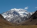
Aconcagua
6961 m
Argentina
Nevado Huascarán
6768 m
Peru
Alpamayo
5947 m
Peru
Nevado Yerupajá
6634 m
Peru
Sajama
6542 m
Bolivia
Nevado Illimani
6483 m
Bolivia
Chimborazo
6310 m
Ecuador
Huayna Potosí
6088 m
Bolivia
Cerro Torre
3133 m
Argentina/Chile


- Known active volcanoes

Cotopaxi
5897 m
Ecuador
Nevado del Huila
5364 m
Colombia
Tungurahua
5010m
Ecuador _
Pichincha
4784 m
Ecuador
Villarrica
2840 m
Chile

.jpg)


- Other Andean volcanoes
- Ojos del Salado , 6893 m (Argentina/Chile)
- Llullaillaco , 6723 m (Argentina/Chile)
- Pissis 6783 m (Argentina)
- Cerro Bonete , 6759 m (Argentina)
- Tres Cruces , 6749 m (Argentina/Chile)
- Walther Penck – formerly Cazadero, 6659 m (Argentina)
- Incahuasi , 6638 m (Argentina/Chile)
- Tupungato , 6800 m , 6570 m , 6500 m (Argentina/Chile)
- Coropuna , 6426 m (Peru)
- Ubinas , 5675 m (Peru)
- Chimborazo , 6310 m (Ecuador)
- Osorno , 2652 m (Chile)
- Sierra Nevada de Lagunas Bravas , 6127 m (Chile/Argentina)
- Lanín , 3747 m (Argentina)
- Uturuncu , 6008 m (Bolivia)
- Licancabur , 5916 m (Bolivia/Chile)
- Ollagüe , 5870 m (Bolivia/Chile)
- Misti , 5822 m (Peru)
- Dozens of smaller volcanoes in the Valley of the Volcanoes (Peru)
elevations and vegetation


The classic division of the tropical Andes into altitude levels was made by the Colombian Francisco José de Caldas , who related this to the respective agricultural uses of the Andes. Only Alexander von Humboldt and Aimé Bonpland used this classification into five levels for a botanical consideration.
- The lowest level is the Tierra Caliente ("hot country"). Tropical lowland rainforest prevails here . Due to the climatic conditions, this part of the Andes is only sparsely populated. Typical agricultural products are cocoa, bananas and sugar cane.
- In the range from 1000 m to 2000 m above sea level lies the Tierra Templada ("temperate country"), which is characterized by tropical mountain rain forest. Coffee, tobacco and corn can be harvested here.
- The main settlement area of the Andes is in the Tierra Fria (“cool land”) at an altitude of 2000 m to 3500 m. In addition to the cultivation of wheat, potatoes and barley, cattle can also be kept here. The natural form of vegetation is the tropical cloud and cloud forest .
- The tree line marks the transition to Tierra Helada ("cold land"). This area is used as grazing land for sheep and llamas. It is the vegetation zone of the Páramo .
- The snow line is at 4800 meters, the beginning of the Tierra Nevada ("snow country") at 4500 meters.
Due to the small distances between lowlands and highlands and the more or less constant humid tropical climate in large refuge areas for millions of years , there is an extremely high biological diversity on the eastern slopes of the tropical Andes .
Altitude levels according to Javier Pulgar Vidal In his main work The Eight Natural Regions of Peru , the Peruvian geographer Javier Pulgar Vidal divides the Andes region of Peru (from the coast to Amazonia ) into eight altitude levels:
- Chala (West, Costa , Pacific Coast) 0–500 m
- Omagua (Amazonía, Tropical Rainforest) 80-400 m
- Rupa-Rupa ( Selva alta ) 400–1000 m
-
Yunga (Tropical Cloud Forest)
- Loma Formation (West) 450–600 m
- Fluvial Yunga (East) 1000–2300 m
- Quechua (east, high valleys, corresponds roughly to a temperate climate) 2300–3500 m
- Suni (also Jalca or Sallqa, plateaus) 3500–4100 m
- Pune 4100-4800m
- Janca > 4800 m
fauna


Four camel-like animal species are native to the Andean plateaux. The population has kept llamas and alpacas as pets for thousands of years, because frugality, endurance and suitability for altitudes of over 4000 meters made them important livestock as early as the Inca period. They were bred from the wild ancestors of the guanacos and vicunas that still exist in the wild. Guanacos live in small herds of up to 25 animals. With a shoulder height of one meter, the vicuna is the smallest of the Andean camels. Due to its fine fur, the vicuna was almost wiped out and only strict protection regulations could keep it in the high Andes.
Other typical Andean mammals are the spectacled bear , which lives in the cloud forests of the tropical Andes; the Andean jackal , which occurs in five subspecies from Venezuela to Tierra del Fuego; two Andean deer species that grow slightly larger than a deer; and the world's smallest deer, the two Pudu species, which are barely larger than rabbits.
Numerous bird species, some of which are endemic , live in the cloud and cloud forests in particular . One of the most striking is the Andean rockbird , found in the Andes from Venezuela to Bolivia. The most well-known bird of prey in the Andes is the Andean condor , a New World vulture that, with a wingspan of up to more than three meters, is one of the largest flying birds in the world.
population and cultures


The central Andes region is one of the areas where the sedentary rural way of life and the early advanced civilizations of mankind originated. A number of food plants were cultivated here as early as the Neolithic Age . The potato , for example, was already cultivated between 8000 and 5000 BC. domesticated . _ The so-called initial phase (2500-2000 BC) ushered in the Andean advanced civilizations in the space between the coast and the Andes of Peru. The oldest city/culture is called Caral ; the last high culture were the Incas. Their most impressive and popular legacy is the city of Machu Picchu , perched at 2430 meters above the Urubamba Valley in the Peruvian region of Cusco . The neighboring indigenous cultures of the Andean eastern rim and the Caribbean region were more or less strongly influenced by advanced civilizations.
The European expansion into South America also began with the Spanish Conquista in the Andes region. Both the thousands of years of their own cultural development and the upheavals of the conquest by the Spaniards, including the massive attempts at conversion by the representatives of Christianity , have left a lasting impression on the inhabitants of the central Andes (especially Quechua and Aymara ).
Typical are the irrigation terraces, llama breeding, the worship of the mother earth called Pachamama and the colorful traditional costumes , which arose from a synthesis of indigenous and Spanish influences. Andean music is world-famous , as it is presented by street musicians from Peru or Ecuador in many European cities.
The southern Andes were only influenced by the Andean civilizations in the north. There the empire of the Mapuche tribes emerged, which was able to expand very quickly to the east coast of Argentina through the use of the horse and founded the equestrian cultures of Patagonia with numerous allied peoples. The Mapuche successfully resisted Spanish colonization for over 300 years. Their state (structured partly on the Spanish model) lasted until 1883. Today, the proportion of indigenous populations in the Andes of Chile and Argentina is far smaller than in the more northern Andean countries , and their cultural heritage is hardly recognizable.
raw materials and economy

The Andes are home to some of what were once the world's largest silver mines ( Cerro de Pasco , Potosí ) and the world's largest copper mine at Calama . Large deposits of sulfur and saltpeter can be mined in Bolivia and northern Chile . This led to territorial disputes between the two countries during the Saltpeter War at the end of the 19th century . There are also many other minerals and valuable metals whose mining is of great economic importance, especially for the poorer central Andean countries. As an example, the world's largest lithium deposits in the Uyuni Salt Lake in Bolivia, the lead production in Peru or the tin production in Bolivia and Peru should be mentioned in this context.
The countries of the Central Andes have been characterized by agriculture since time immemorial. They are home to the greatest (genetic) diversity of different food plants in the world. Extensive long-distance grazing with alpacas has been established on the dry highland steppes . It is very similar to the transhumance from the old world .
See also
- Physical Geography of South America
- List of mountains or elevations in South America
- Nudo de Paramillo
- ahead
web links
- The Argentine Andes ( May 31, 2011 Memento at Internet Archive ) (Spanish)
- Volcanism in the Andes ( May 31, 2011 Memento at Internet Archive ) (Spanish)
literature
- Axel Borsdorf, Christoph Stadel: The Andes: A geographical portrait , Springer spectrum, Berlin 2013, 453 pages, ISBN 978-3-8274-2457-0 .
- Mary Strong: Art, Nature, and Religion in the Central Andes: Themes and Variations from Prehistory to the Present. University of Texas, Austin 2012, ISBN 978-0-292-73571-2 .
- Klaus Heine, Hans-Peter Niller: The Andes of South America: Geoarchive for environmental changes and climate change. Geographical Review 56(3), pp. 4–13 (2004), ISSN 0016-7460
itemizations
- ^ NASA
- ↑ Conradin Burga, Frank Kloetzli and Georg Grabherr (eds.): Mountains of the earth - landscape, climate, flora. Ulmer, Stuttgart 2004, ISBN 3-8001-4165-5 . pp. 20-21.
- ↑ a b Axel Borsdorf, Christoph Stadel: The Andes (see Literature), pp. 5-6.
- ^ Noticiero Salta: ¿El Cono de Arita es natural o un monumento milenario? ( Memento of 1 February 2013 at Internet Archive ) (Spanish)
- ↑ Figure 9.4. Mapa de Provincias Geológicas del territorio argentino on insugeo.org.ar , Capítulo 9: Geología Regional Sudamericana , Tucumán National University , retrieved September 10, 2021.
- ↑ R Alonso, Bodo Bookhagen, Barbara Carrapa, Isabelle Coutand, Michael Haschke, George Hilley, Lindsay Schoenbohm, Edward Sobel, Manfred Strecker, Martin Trauth, Arturo Villanueva: Tectonics, Climates, and Landscape Evolution of the Southern Central Andes: The Argentine Puna Plateau and adjacent Regions between 22 and 30º lat. in The Andes: Active Subduction Orogeny , 2006, DOI: 10.1007/978-3-540-48684-8_12, Fig 12 .
- ↑ Note: It is assumed that the Nazca Plate together with the Cocos Plate and oceanic lithosphere, which has long since been subducted under North America and is still preserved today in relict form by the Juan de Fuca Plate , is assumed to form a contiguous East Pacific up to the older Cenozoic formed a plate called the Farallon Plate .
- ↑ a b c FA Capitanio, C Faccenna, S Zlotnik, DR Stegman: Subduction dynamics and the origin of Andean orogeny and the Bolivian orocline. Nature. Vol. 480 (No. 7375), 2011, pp. 83-86, doi:10.1038/nature10596
- ↑ Paul G Silver, Raymond M Russo, Carolina Lithgow-Bertelloni: Coupling of South American and African Plate Motion and Plate Deformation. Science. Vol. 279 (No. 5347), 1998, pp. 60-63, doi:10.1126/science.279.5347.60
- ↑ R. Somoza: Updated Nazca (Farallon)—South America relative motions during the last 40 My: implications for mountain building in the central Andean region. Journal of South American Earth Sciences. Vol. 11, No. 3, 1998, pp. 60-63, doi:10.1126/science.279.5347.60
- ↑ Prosenjit Ghosh, Carmala N Garzione, John M Eiler: Rapid Uplift of the Altiplano Revealed Through 13 C- 18 O Bonds in Paleosol Carbonates. Science. Vol. 311 (No. 5760), 2006, pp. 511-515, doi:10.1126/science.1119365
- ↑ Most 6000-m Andes mountains climbed . In: Guinness World Records . ( Online [accessed 18 April 2018]).
- ↑ John Biggar: Andes Website - The definitive list of 6000 m mountain peaks in South America. Retrieved April 18, 2018 .
- ↑ BBC Brasil – Notícias – Alpinista quer completar maratona de 117 picos mais altos dos Andes. Retrieved April 18, 2018 (Brazilian Portuguese).
- ↑ Most 6000-m Andes mountains climbed . In: Guinness World Records . ( Online [accessed 18 April 2018]).
- ↑ Paul Schaufelberger: Caldas-Lang-Vilensky climate systematics in climate, climate soil and climate vegetation types , Tab. 5, p. 41, pdf version , probably 1958, retrieved on October 17, 2020. p. 35.
- ↑ Christoph Stadel (1992): Altitudinal Belts in the Tropical Andes: Their Ecology and Human Utilization, Yearbook of the Conference of Latin Americanist Geographers , 17/18 , 45–60
- ↑ Javier Pulgar Vidal: Geografía del Perú; Las Ocho Regiones Naturales del Peru . Edit. Universo SA, Lima 1979 (First publication: Javier Pulgar Vidal: Las ocho regiones naturales del Perú. In: Boletín del Museo de historia natural "Javier Prado". n° especial 17. Lima 1941, pp. 145-161.).
- ↑ Seibert, Paul (1996); Color Atlas South America; Publisher Eugen Ulmer, Stuttgart, pp. 288.
- ↑ Axel Borsdorf and Christoph Stadel: The Andes: A geographical portrait. Springer, Berlin/Heidelberg 2013, ISBN 978-3-8274-2457-0 . pp. 276-277.