
Santa Cruz de la Sierra
| Santa Cruz | ||
|---|---|---|
|
Coordinates: 17 ° 47 ′ S , 63 ° 12 ′ W Santa Cruz on the map of Bolivia
|
||
| Basic data | ||
| Country | Bolivia | |
| Department | Santa Cruz Department | |
| City foundation | February 26, 1561 | |
| Residents | 1,441,406 (2012 census) | |
| City insignia | ||
 |
 |
|
| Detailed data | ||
| surface | 325.57 km 2 | |
| Population density | 4427 inhabitants / km 2 | |
| height | 437 m | |
| City structure | 16 distritos | |
| Waters | Río Piraí , Río Grande | |
| Post Code | 07-0101-0100-1001 | |
| prefix | (+591) | |
| Time zone | UTC −4 | |
| City Presidency | Percy Fernández (FAJPT) | |
| Website | ||
 |
||
 |
||

Santa Cruz de la Sierra is the capital of the Santa Cruz Department in southeastern Bolivia , about 550 km east of La Paz . The city had 1,441,406 inhabitants (2012), making it the largest city in the country.
location
It is located at about 437 m within a fertile flatland on the edge of the Cordillera Oriental mountain range , which was previously covered by tropical rainforest , but is now mostly cultivated land . On the western outskirts of the city flows the Río Piraí (also Piray ), east of the city the Río Grande (or: Guapay).
history

Santa Cruz de la Sierra was founded on February 26, 1561 by Ñuflo de Chávez near the present-day town of San José de Chiquitos (about 250 kilometers east of present-day Santa Cruz); Ñuflo de Chávez named the settlement after his homonymous village in Extremadura , Spain , twelve kilometers south of Trujillo . The Spanish place name means Holy Cross of the Mountains .
In 1592 , the city was moved to its current location, as the original location had proven to be unfavorable due to conflicts with the indigenous people. To the south of San José de Chiquitos (which was not established as a Jesuit mission until 1750) the remains of the first settlement can be visited as an archaeological excavation site Santa Cruz la Vieja ("Old Santa Cruz").
For a long time Santa Cruz was a small town characterized by agriculture and cattle breeding, the purpose of which was to supply the highlands with agricultural products. After Bolivia's independence, Santa Cruz became the capital of the newly created department of the same name in 1826, but it remained a relatively remote and difficult to reach small town.
At the beginning of the 20th century, Santa Cruz lost a lot of its importance because with the opening of the railway lines from the highlands to the Pacific coast, the import of agricultural products from abroad became much cheaper than the laborious transport with mules from Santa Cruz.

Santa Cruz's economic boom and growth to its present-day importance began after major roads connected it to the rest of the country in the 1950s and developed the region's extensive oil and gas reserves.
Due to the position it has now achieved as the economic center of Bolivia, there are political currents calling for greater independence from the central government in La Paz and regional autonomy .
economy
The main industry in the city is the processing of agricultural products (tropical products such as coffee , sugar cane and tobacco ) that are grown in the surrounding area. Agriculture has been booming in the zone for several years, so that the population of the city and the surrounding area has increased very quickly. The climate at the transition from the Amazon basin to the Gran Chaco is tropical and temperate with a rainy season in summer. Temperatures vary between 20 ° C in winter and up to 40 ° C in summer. In winter, cold southerly winds ( surazos ) with a polar origin can cause sudden cold spells with temperatures of around 10 ° C.
The Santa Cruz region has the second largest natural gas reserves in South America .
Cityscape


Santa Cruz is considered the most architecturally modern, economically dynamic and prosperous city of Bolivia. It is a university town and the seat of the German school . The city is divided by a main road network of large ring roads ( Anillos ), which run circularly around the center and straight arterial roads ( Radiales ), which run in a star shape to the innermost First Ring ( Primer Anillo ). Most of the important intersections of the access roads and ring roads are designed as large roundabouts with prominent monuments in the middle (which makes orientation easier).
Inside the first ring is the old city center with its checkerboard network of streets, in the center of which is the popular strolling point of September 24th ( Plaza 24 de Septiembre ), around which Santa Cruz has retained the small-town charm of the Spanish colonial era. Most of the buildings are adorned with canopies with columns. In the central square you will find the cathedral of Santa Cruz de la Sierra , the prefecture and the town hall as well as the cultural center as well as popular restaurants and cinemas. A few streets to the north is the small Parque El Arenal ( "sandpit park" ) around a pond with the "Ethno-Folkloric Museum" (customs, clothing and musical instruments of the indigenous people), in the vicinity of which there are also cinemas, restaurants, pubs and discos .
Only since the 1950s has the city grown beyond the colonial center. The new buildings outside the first ring are mostly low and appear uniform and faceless over long stretches with wide, straight streets designed for car traffic. Mainly on the major access and ring roads there are shopping centers and companies that set urban accents with their larger and higher, architecturally partially outstanding buildings. Overall, the cityscape of Santa Cruz outside the colonial center is very reminiscent of the character of North American (sub) cities. There are also extensive industrial areas, particularly in the east and north of the city.
In the north-west, within the third ring, is the upscale and affluent district of Equipetrol, which with its restaurants and cinemas is particularly popular with the upper class as a place to live and to go out. The German school is also located in this quarter.
In the west and northwest of the urban area, the Río Piraí flows through the city, whose banks are popular as a local recreation area.
The closed urban development ends outside the fourth ring. In many places the city continues to grow on its fringes - more or less planned - above all as a result of the (sometimes illegal) settlement construction by rural people. In contrast to other Latin American metropolises, however, there are no distinct slums; the new districts on the outskirts are usually legalized and connected to the urban infrastructure.
The Palacio de Justicia de Santa Cruz de la Sierra is characteristic .
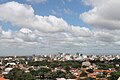
City center south

City center-south at night

City center north


Population development
The population development has made the city into a metropolis and the largest city in Bolivia in just a few decades:
| year | Residents | source |
|---|---|---|
| 1976 | 254 682 | census |
| 1992 | 697 278 | census |
| 2001 | 1 113 582 | census |
| 2012 | 1,453,549 | census |
traffic
Santa Cruz has two airports, the completely rebuilt city airport El Trompillo , located southeast close to the center, and the newer Viru Viru Internacional located 18 kilometers northeast . The railway lines of Ferroviaria Oriental SA connect Santa Cruz in the east with Puerto Quijarro on the border with Brazil and in the south with Yacuiba on the border with Argentina . Santa Cruz is connected to the rest of the country by main roads to Cochabamba , Yacuiba and the Beni Department in the north . The hub of passenger transport is the combined railway and bus station Terminal Bimodal , which opened in 2001 in the east of the city.

For inner-city traffic, there is a dense network of minibuses ( micros ) and regular public transport taxis ( Trufis ) that stop when you call or wave , which leads to congestion , especially in narrow streets in the city center (with many lines). Attempts by the city administration to organize bus traffic by setting up mandatory stops have so far been unsuccessful. In addition, there are often traffic obstructions by traders who (forbidden) hog pavements and sometimes even carriageways with their sales stands, which push pedestrians onto the lanes and narrow the streets. The main part of the traffic volume consists of buses and taxis, the share of private cars in road traffic was very low (by European standards). However, there has been a noticeable increase in the share of private vehicles since 2015.
The relatively narrow streets in the colonial center are mostly one-way streets, the Platz des 24th September, located in the heart of the old town, and the adjacent streets are closed to buses and trucks and some of them are traffic-calmed.
Town twinning
-
 La Plata , Argentina (since 1994)
 -
 Miami-Dade County , Florida, USA
 -
Paraná , Argentina
-
Rosario , Argentina
sons and daughters of the town
- Germán Busch Becerra (1904–1939), soldier and President
- Werner Fischer (* 1931), German historian
- Guido Náyar Parada (* 1962), politician
- Juan Manuel Peña (* 1973), football player
- Jaime Moreno (* 1974), football player
- Luis Fernando Camacho Vaca (* 1979), entrepreneur, right-wing extremist and Christian fundamentalist
- Marcelo Moreno Martins (* 1987), football player
- Federico Zeballos (* 1988), tennis player
Climate table
| Santa Cruz de la Sierra | ||||||||||||||||||||||||||||||||||||||||||||||||
|---|---|---|---|---|---|---|---|---|---|---|---|---|---|---|---|---|---|---|---|---|---|---|---|---|---|---|---|---|---|---|---|---|---|---|---|---|---|---|---|---|---|---|---|---|---|---|---|---|
| Climate diagram | ||||||||||||||||||||||||||||||||||||||||||||||||
| ||||||||||||||||||||||||||||||||||||||||||||||||
|
Average monthly temperatures and rainfall for Santa Cruz de la Sierra
Source: wetterkontor.de
|
|||||||||||||||||||||||||||||||||||||||||||||||||||||||||||||||||||||||||||||||||||||||||||||||||||||||||
See also
- Palmasola , prisoners town (prison) in the district 9 (Palmasola)
Individual evidence
- ↑ a b INE - Instituto Nacional de Estadística Bolivia 2012
- ↑ Klett climate map of South America
- ↑ Santa Cruz de la Sierra: Start of the journey through Bolivia. In: katetravels - travel blog: travel, vanlife, surfing and yoga. Retrieved September 6, 2019 (German).
- ↑ a b INE - Instituto Nacional de Estadística Bolivia 1992
- ^ INE - Instituto Nacional de Estadística Bolivia 2001
Web links
- Official website of the city of Santa Cruz de la Sierra (Spanish)
- Interactive city map (Spanish)
- Website of the German School in Santa Cruz
- SantaCruz-Online Virtual Travel Guide with detailed information about Santa Cruz de la Sierra
- Relief map of the Santa Cruz region 1: 250,000 (PDF; 7.88 MB)
- Municipio Santa Cruz - General Maps No. 70101
- Municipio Santa Cruz - detailed map and population data (PDF; 807 kB) ( Spanish )
- Department Santa Cruz - Social data of the municipalities (PDF; 4.99 MB) ( Spanish )