Yacuiba
| Yacuiba | ||
|---|---|---|
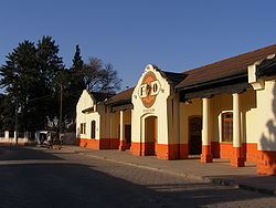
 Yacuiba Railway Station |
||
| Basic data | ||
| Residents (state) | 61,844 pop. (2012 census) | |
| rank | Rank 13 | |
| height | 628 m | |
| Post Code | 06-0301-0100-1001 | |
| Telephone code | (+591) | |
| Coordinates | 22 ° 1 ′ S , 63 ° 41 ′ W | |
|
|
||
| politics | ||
| Department | Tarija | |
| province | Gran Chaco Province | |
| Homepage of Yacuiba | ||
| climate | ||
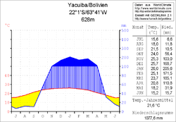
 Climate diagram Yacuiba |
||
Yacuiba is a medium- sized town in the Tarija Department in the southern part of the South American Andean state of Bolivia , right on the border with Argentina . Due to a special agreement with the Argentine government from 1925, it is the only Bolivian place between Voranden and the Río Pilcomayo , which is south of the 22nd parallel.
Location in the vicinity
The border town is located at an altitude of 620 to 680 m on the eastern edge of the Voranden ( Serranía Aguaragüe ) and on the western edge of the vast South American lowland Gran Chaco on the railway line between the cities of Santa Cruz in Bolivia and Salta in Argentina.
Yacuiba is the central place of the district ( Bolivian : Municipio ) Yacuiba and capital of the autonomous province of Gran Chaco since 2017 . It is located east of the capital Tarija , south of Villamontes and north of the airport in the Argentine city of Tartagal . The city has its own small airport with the international airport code BYC and regular connections to domestic destinations.
geography
Yacuiba has a warm, temperate climate with a pronounced rainy season from December to March with consistently high temperatures, and a dry season in the southern winter from June to September with warm daytime and cool nighttime temperatures. Although Yacuiba is not on a major river, flooding of the urban area during the rainy season is not uncommon. For example, the Yuquirenda gorge ( quebrada ) can fill up with water and overflow very quickly during heavy rain.
population
The population of the city on the Bolivian-Argentine border has grown rapidly:
| year | Residents | source |
|---|---|---|
| 1976 | 14 354 | census |
| 1992 | 34 505 | census |
| 2001 | 64 611 | census |
| 2012 | 61 844 | census |
Transport network
Tarija , the capital of the department, is only 121 kilometers from Yacuiba as the crow flies, but in earlier years it was practically inaccessible by land due to around half a dozen mountain ridges in between. Even today, the air route is the much more comfortable option. There are regular and inexpensive direct connections. As a result of extensive road construction projects at the beginning of the 21st century, there is now an acceptable route for buses, trucks and cars with a length of 279 kilometers of road.
To get to Tarija, follow the Ruta 9 road from Yacuiba for 15 kilometers to the village of Campo Pajoso . There the Ruta 29 branches off to the northwest and after 83 kilometers via Caraparí reaches the village of Palos Blancos . The road meets Ruta 11 here , coming from the border with Paraguay via Villamontes and Palos Blancos in a westerly direction via Entre Ríos to Tarija, where it meets Ruta 1 eight kilometers before Tarija . Via this route 1 , Yacuiba is then connected to the large metropolises of the highlands, with Potosí , Oruro , El Alto and La Paz .
If you follow the Ruta 9 further north via Campo Pajoso , the entire Bolivian lowland opens up on this highway, because the Ruta 9 leads via the departmental capitals Santa Cruz and Trinidad to Guayaramerín on the border with Brazil in the extreme northeast of the country.
tourism
The biggest annual festival in Yacuiba is the "FESTIFRONT" -Festival de la Frontera- a folklore festival in which musicians from all over Bolivia and northern Argentina take part. Thanks to its location on the Argentine border, Yacuiba is an important trading center.
Individual evidence
- ↑ Thomas Brinkhoff: City Population
- ↑ Instituto Nacional de Estadística Bolivia (INE) 1992 ( Memento from April 23, 2014 in the Internet Archive )
- ^ INE - Instituto Nacional de Estadística Bolivia 2001 ( Memento of February 6, 2017 in the Internet Archive )
- ^ INE - Instituto Nacional de Estadística Bolivia 2012 ( Memento from March 4, 2016 in the Internet Archive )
Web links
- Yacuiba website ( Spanish )
- Relief map of the Bermejo region 1: 250,000 (PDF; 1.15 MB)
- Municipio Yacuiba - General Maps No. 60301
- Municipio Yacuiba - detailed map and population data (PDF; 407 kB) ( Spanish )
- Departamento Tarija - social data of the municipalities (PDF; 3.05 MB) ( Spanish )
