Municipio Yacuiba
| Municipio Yacuiba | ||
|---|---|---|
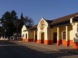
 Yacuiba Railway Station |
||
| Basic data
|
||
| Population (state) - population density |
91,998 inhabitants (2012 census) 23 inhabitants / km² |
|
| Post Code | 06-0301 | |
| Telephone code | (+591) | |
| surface | 4,054 km² | |
| Coordinates | 21 ° 42 ′ S , 63 ° 10 ′ W | |
|
|
||
| politics
|
||
| Department | Tarija | |
| province | Gran Chaco Province | |
| Central place | Yacuiba | |
| climate | ||
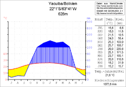
 Climate diagram Yacuiba |
||
The Municipio Yacuiba is a district in the Tarija Department in the South American Andean state of Bolivia .
Location in the vicinity
The Municipio Yacuiba is the middle of the three Municipios of the Gran Chaco Province . It borders the Municipio Villamontes to the east and north , the Municipio Caraparí to the west , and the Republic of Argentina to the south .
The capital of the municipality is the border town of Yacuiba with 61,844 inhabitants (2012) in the south of the district.
geography
The municipality of Yacuiba has a warm and temperate climate with a pronounced rainy season from December to March with consistently high temperatures, and a dry season in the southern winter from June to September with warm daytime and cool nighttime temperatures.
The municipality is traversed by the Río Pilcomayo on the border with the neighboring municipality of Villamontes .
population
The population of the Municipio Yacuiba has almost doubled in the past two decades:
- 1992 : 47,228 inhabitants ( census )
- 2001 : 83,518 inhabitants (census)
- 2012 : 91,998 inhabitants (census)
The population density of the municipality is 22.7 inhabitants / km², the proportion of the urban population is 69.7% ( 2012 ).
The life expectancy of newborns in 2001 was 66.7 years. The literacy rate among those over 19 is 88 percent, 94 percent for men and 82 percent for women ( 2001 ).
politics
Results of the elections for the municipal council ( concejales del municipio ) in the regional elections on April 4, 2010:
| electoral legitimate |
electoral participation |
valid votes | PAN | PAIS | MAS-IPSP | CC | MSM | DECIDE | ||
|---|---|---|---|---|---|---|---|---|---|---|
| 46,908 | 39,018 | 30,617 | 12,870 | 7,735 | 5.111 | 3,061 | 1,398 | 442 | ||
| 83.2% | 78.5% | 42.0% | 25.3% | 16.7% | 10.0% | 4.6% | 1.4% |
structure
The municipality has an area of 4,054 km² and is divided into the following cantons :
- 06-0301-01 Canton Yacuiba - 53 localities - 74,929 inhabitants ( 2012 )
- 06-0301-02 Caiza canton - 60 localities - 14.094 inhabitants
- 06-0301-03 Canton of Aguayrenda - 7 localities - 2,975 inhabitants
Localities in the municipality of Yacuiba
- Yacuiba Canton
- Yacuiba pop. 61,844 - Campo Grande pop 2246 - San Isidro pop 1346 - Lapachal Alto pop 1039 - Campo Pajoso pop 1012 - Crevaux pop 985 - Independencia La Grampa pop 642 - La Grampa pop 556.
- Canton of Caiza
- Villa El Carmen 1813 pop - El Brial 1405 pop - Yaguacua 1323 pop - Tierras Nuevas 1039 pop - Sanandita 712 pop - Sachapera 561 pop - Caiza "J" 502 pop - Bagual 327 pop - Villa Ingavi 175 Pop.
- Canton of Aguayrenda
- Palmar Chico 1766 pop.
Individual evidence
- ↑ Instituto Nacional de Estadística (INE) 1992
- ^ Instituto Nacional de Estadística (INE) 2001
- ↑ Instituto Nacional de Estadística (INE) 2012 ( Memento of the original of July 22, 2011 in the Internet Archive ) Info: The archive link has been inserted automatically and has not yet been checked. Please check the original and archive link according to the instructions and then remove this notice.
- ↑ Acta de computo Nacional Electoral Departamentales, Municipales y Regional 2010
Web links
- Municipio Yacuiba - General Maps No. 60301
- Municipio Yacuiba - detailed map and population data (PDF; 407 kB) ( Spanish )
- Departamento Tarija - social data of the municipalities (PDF; 3.05 MB) ( Spanish )
