Tierras Nuevas
| Tierras Nuevas | ||
|---|---|---|
| Basic data | ||
| Residents (state) | 1039 pop. (2012 census) | |
| height | 622 m | |
| Post Code | 06-0301-0201-6001 | |
| Telephone code | (+591) | |
| Coordinates | 21 ° 45 ′ S , 63 ° 34 ′ W | |
|
|
||
| politics | ||
| Department | Tarija | |
| province | Gran Chaco Province | |
| climate | ||
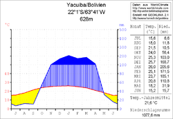
 Climate diagram Yacuiba |
||
Tierras Nuevas is a town in the Tarija Department in the South American Andean state of Bolivia .
Location in the vicinity
Tierras Nuevas is the sixth largest town in the canton of Caiza "J" in the district ( Bolivian : Municipio ) of Yacuiba in the Gran Chaco province . The place is at an altitude of 622 m about thirty kilometers north of the Bolivian-Argentine border. To the west of the village runs in a north-south direction of the Serranía Aguaragüe , which here reaches heights of more than 1200 m.
geography
Tierras Nuevas is located on the southeastern edge of the Bolivian Andes chain in the lowlands of the subtropical Gran Chaco , which extends over northwest Paraguay , northeast Argentina and southeast Bolivia.
The climate is subtropical with hot humid summers and moderately warm and dry winters. The annual average temperature is almost 22 ° C, the average monthly values fluctuate between 15 ° C in June / July and 26 ° C in January (see Yacuiba climate diagram). Annual precipitation is just under 1100 mm, with a four-month dry season from June to September with monthly precipitation below 15 mm and a humidity period from December to March with 160–200 mm monthly precipitation.
Transport network
Tierras Nuevas is located 307 kilometers southeast of Tarija , the capital of the department, and nineteen kilometers north of the border town of Yacuiba .
From Tarija, the Ruta 11 trunk road leads east over the cities of Entre Ríos and Palos Blancos for 250 kilometers to Villamontes . There it meets the north-south running Ruta 9 , which leads south via Sachapera to Tierras Nuevas and further via Villa El Carmen (Caipitandi) , Palmar Chico and Yacuiba to the Argentine border.
population
The population of the village is in the decade between the last two censuses risen by more than half:
| year | Residents | source |
|---|---|---|
| 1992 | no detailed data | census |
| 2001 | 613 | census |
| 2012 | 1 039 | census |
Due to the historically grown population distribution, the region has a certain proportion of Quechua population, in the Municipio Yacuiba 17.6 percent of the population speak the Quechua language.
Individual evidence
- ^ Instituto Nacional de Estadística Bolivia (INE) 1992
- ^ INE - Instituto Nacional de Estadística Bolivia 2001
- ↑ INE - Instituto Nacional de Estadística Bolivia 2012 ( Memento of the original from July 22, 2011 in the Internet Archive ) Info: The archive link has been inserted automatically and has not yet been checked. Please check the original and archive link according to the instructions and then remove this notice.
- ↑ INE social data Tarija 2001 (PDF file; 3.05 MB)
Web links
- Relief map of the Villamontes region 1: 250,000 (PDF; 5.68 MB)
- Municipio Yacuiba - General Maps No. 60301
- Municipio Yacuiba - detailed map and population data (PDF; 407 kB) ( Spanish )
- Departamento Tarija - social data of the provinces and municipalities (PDF; 3.05 MB) ( Spanish )
