Villarrica (volcano)
| Villarrica | ||
|---|---|---|
|
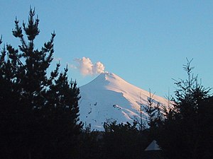
The Villarrica volcano south of Pucón |
||
| height | 2847 m | |
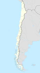
| location | Araucanía ( Chile ) | |
| Mountains | To the | |
| Coordinates | 39 ° 25 ′ 14 ″ S , 71 ° 56 ′ 23 ″ W | |
|
|
||
| Type | Stratovolcano | |
| Last eruption | 2019 | |
| particularities | is one of the most active volcanoes in Chile | |
Villarrica is a 2847 m high active volcano in Chile , which lies on the border of the regions of Araucanía and Los Ríos . To the north of the volcano are the town of Pucón and Lake Villarrica .
The first recorded eruption dates from 1558. In 1575, the town of Villarrica was devastated by a severe earthquake , killing 350 residents. Other large eruptions followed in 1640 and 1948. In 1971 there was a mudslide created by melted ice and hot lava . The mudslide ( lahar ) destroyed a number of houses, farmland and bridges.
Over 50 eruptions have been recorded in the past 500 years. A more powerful eruption took place on March 3, 2015. Around 3,600 people were evacuated because of the outbreak.
The last outbreak occurred on January 4, 2019.
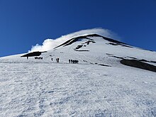
The Villarrica volcano in the Villarrica National Park is one of the most famous tourist destinations in Chile. In the summer months there are regular guided tours to the edge of the crater, which can also be mastered by inexperienced mountaineers.
In 2010 a lava lake was still active here.
Web links
- Villarrica (Vulkan) in the Global Volcanism Program of the Smithsonian Institution (English)
- Chilean volcano monitoring Sernagomin zu Villarrica (Spanish)
- Webcams from Sernagomin
Footnotes
- ^ Volcán Villarrica ( es ) Servicio Nacional de Geología y Minería. Retrieved March 29, 2018.
- ↑ Thousands evacuated after volcanic eruption , NZZ, March 3, 2015
- ↑ [1] , Twitter #VolcanVillarrica, March 3, 2015


