
Villarrica National Park
| Villarrica National Park | |||
|---|---|---|---|
 |
|||
|
|||
| Location: | Araucanía , Los Ríos , Chile | ||
| Next city: | Temuco | ||
| Surface: | 630 km² | ||
| Founding: | 1940 Chile | ||

The Villarrica National Park is located east of the lake of the same name, Lago Villarrica, in the 'Little South' of Chile . It extends from Pucón to the Argentine border . This oldest national park in Chile covers an area of 63,000 ha. It ranges from araucarias and lenga forests to barren, volcanic gravel areas to the glacier region and is divided into three zones:
The Rucapillán zone includes the very active Villarrica volcano (2845 m), which is heavily glaciated to the south and is the main attraction of the national park. The summit is often climbed from the north. The national park administration tolerates a private ascent only in the case of low volcanic activity, appropriate glacier equipment and proof of alpine experience.
The Quetrupillán zone includes the extinct volcanic hull of the same name (2382 m), which has only a slight glaciation from the former crater to the south.
The Puesco zone extends to the Chilean-Argentine border, where it also reaches its greatest height in the Lanín volcano (3776 m).
The park borders directly on the Argentine Lanín National Park to the east .

Araucarias in the Quetrupillán zone
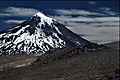
Volcan Lanín from the northwest

The destroyed cable car station on the normal route to Villarrica

Araucarias and golden inca lilies in the national park


Web links
Alberto de Agostini | Alerce Andino | Alerce Costero | Bernardo O'Higgins | Bosque de Fray Jorge | Chiloe | Conguillío | Corcovado | Hornopirén | Huerquehue | Isla Guamblin | Isla Magdalena | Juan Fernández Archipelago | Cape Horn | La Campana | Laguna del Laja | Laguna San Rafael | Las Palmas de Cocalán | Lauca | Llanos de Challe | Llullaillaco | Morro Moreno | Nahuelbuta | Nevado Tres Cruces | Pali Aike | Pan de Azúcar | Puyehue | Queulat | Radal Siete Tazas | Rapa Nui | Salar del Huasco | Tolhuaca | Torres del Paine | Vicente Pérez Rosales | Villarrica | Volcán Isluga