Bernardo O'Higgins National Park
| Bernardo O'Higgins National Park | ||
|---|---|---|
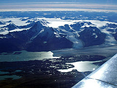
| Campo de Hielo Sur glacier area | ||
|
|
||
| Location: | Magallanes and Chilean Antarctica , Chile | |
| Next city: | Puerto Natales | |
| Surface: | 35259 km² | |
| Founding: | 1969 Chile | |
The Bernardo O'Higgins National Park (Spanish: Parque Nacional Bernardo O'Higgins ) is the largest national park in Chile with around 35,000 km² and is located in the Andes . The park is named after Bernardo O'Higgins , the first President of Chile.
geography
Geographical location
The national park is located between the Región de Aisén and the Región de Magallanes y de la Antártica Chilena in southern Chile between the 48 ° and 51 ° 38 'south latitude . It begins in the south over Isla Evans and extends to about 400 km north of Villa O'Higgins . The city of Puerto Natales is about 100 km southeast. You travel through the Última Esperanza Fjord, Puerto Natales and Puerto Toro to the glaciers Serrano and Balcemeda. One often encounters icebergs floating in the fjords.
Neighboring national parks around the Bernardo O'Higgins National Park are in the east of the Torres del Paine (Chile, 50 km) and Los Glaciares ( Argentina ) and in the north of the Laguna San Rafael (Chile). In the north-west there is also the Alacalufes Reserve , in the south-west the Katalalixar Reserve .
glacier
The park includes a large part of the Campo de Hielo Sur glacier area. One of the main attractions is the Pío XI glacier , the largest inland glacier of the Campo de Hielo Sur. With an area of 1265 km² and a height of up to 75 m, the Pío XI is the largest glacier in the southern hemisphere outside of Antarctica . The glacier has advanced about 10 km in the past 50 years.
nature
Andean condors and eagles can be seen on the cliffs near Punta Barrosa . Frequently you will encounter sea lions - and great cormorant colonies.
particularities
In June 2007, the temporary disappearance of the approximately 2 hectare Tempanos glacial lake in the park, which had only been created in 1986, was reported. While at the end of March 2007 the park rangers had not found any changes to the lake, the next time the park rangers visited, only a crater about 30 m deep was left. The reason for the disappearance of the water from the glacial lake is probably a glacier run . A few weeks later it was found that the lake was filling up with water very slowly.
See also
Web links
- Information about the park (English; archive version)

