Campo de Hielo Sur
| Campo de Hielo Sur | ||
|---|---|---|
|
Satellite image of a section in the northeast of the Campo de Hielo Sur, in the center of the picture is the O'Higgins Glacier , one of the larger outlet glaciers. The Lautaro volcano is in the upper part of the picture . |
||
| location | Patagonia , Chile / Argentina | |
| Mountains | To the | |
| Type | Plateau glacier | |
| length | 350 km | |
| surface | 13,000 km² | |
| Altitude range | 3380 m - 0 m | |
| width | an average of 30–40 km | |
| Coordinates | 50 ° 0 ′ S , 73 ° 30 ′ W | |
|
|
||
| drainage | Various outlet glaciers | |
| particularities | Largest glacier area in the southern hemisphere outside of Antarctica | |
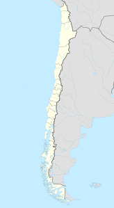
The Campo de Hielo Sur (Spanish for "southern ice field"; also Campo de Hielo Patagónico Sur , southern Patagonian ice field ) is the largest glacier area in Patagonia and the largest in the southern hemisphere outside of Antarctica . It is located in the Andes , partly in Chile , partly in Argentina .
The length of the glacier area, the extension in north-south direction, is 350 km, the width is mostly between 30 and 40 km. The area is approximately 13,000 km².
In 1943 the glacier area was photographed from the air with military aircraft on behalf of the Chilean government. Then the area was explored by the expeditions of Federico Reichert and Alberto de Agostini . Nevertheless, parts of the area have not yet been entered.
The Campo de Hielo Sur is considered to be the largest freshwater reservoir in South America.
Demarcation
For the 60 km long section of the Chilean-Argentine border between the mountains Cerro Fitz Roy and El Murallón , no mutual agreement has yet been found. The section of the glacier could not yet be precisely measured.
In 1998 the presidents Eduardo Frei Ruiz-Tagle (Chile) and Carlos Menem (Argentina) declared this section a special zone. They agreed to have this zone marked on all maps. The zone should be framed by a square and no border should be drawn within the frame. A short explanatory note should be printed for this purpose.
In 2006 the Argentine Instituto Geográfico Militar published a map without the frame, without the explanatory note and with the maximum Argentine requirement of an official border line. After a diplomatic protest note and a summit meeting between Michelle Bachelet and Néstor Kirchner , the card was withdrawn from circulation.
glacier
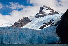
The Campo de Hielo Sur has numerous outlet glaciers , some of them huge . With the exception of two glaciers, all of the larger glaciers calve at their ends. The western ones reach a pacific fjord , the eastern calves in glacial lakes .
The largest glaciers in Campo de Hielo Sur include:
- Pío XI Glacier , 1,265 km²
- Viedma Glacier , 978 km²
- Upsala Glacier , 902 km²
- Perito Moreno Glacier , 258 km²
- Balmaceda glacier
- Serrano Glacier
- Geike glacier
- Gray glacier
- Jorge Montt Glacier
National parks
Parts of the Campo de Hielo Sur belong to the following national parks:
- Torres del Paine National Park , Chile
- Bernardo O'Higgins National Park , Chile
- Los Glaciares National Park , Argentina
See also
- Campo de Hielo Norte ( North Patagonian Ice Field)
- List of territorial disputes
Web links
Individual evidence
- ↑ a b c A. White, L. Copland: Spatial and temporal variations of glacier extent across the Southern Patagonian Icefield since the 1970s. In: The Cryosphere Discussion . 7: 1–34, 2013 ( online ; PDF; 5.9 MB)
- ↑ a b M. Aniya et al .: The use of satellite and airborne imagery to inventory outlet glaciers of the Southern Patagonia Icefield, South America. In: Photogrammetric Engineering & Remote Sensing. 12: 1361–1369, 1996 ( online ; PDF; 2.8 MB)
- ^ Subsecretario argentino de turismo dice que mapa de Campos de Hielo es oficial , El Mercurio, August 29, 2006
- ↑ Hielos Continentales: reclamo de Chile por los mapas argentinos , Clarín, August 29, 2006


