
icecap
An ice cap or plateau glacier is an extensive, solid land-covering glacier with an area of less than 50,000 km² . In contrast to this are the ice sheets with an area of more than 50,000 km².
properties
Ice caps are not limited by steep slopes or other topographical features like valley glaciers , but flat, dome-shaped structures, usually with a central dome as the highest point, which forms an ice divide . The ice flow is directed away from this dome towards the edge of the ice cap. Many ice caps have outlet glaciers similar to the valley glaciers .
Examples of ice caps
- Stikine Ice Cap ( Alaska and Canada ) (21,876 km²)
- Agassiz Ice Cap ( Ellesmere Island , Canada) (21,000 km²)
- Ice cap of the North Island (Novaya Zemlya) (19,800 km²)
- Campo de Hielo Sur ( Patagonia , Chile and Argentina ) (16,800 km²)
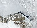
- Austfonna ( Nordostland , Spitzbergen ) (8,120 km²)
- Vatnajökull ( Iceland ) (8,100 km²)
- Penny Ice Cap ( Baffin Island , Canada) (6,000 km²)
- Campo de Hielo Norte (Patagonia, Chile and Argentina) (4,200 km²)
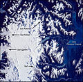
- Hans Tausen Ice Cap ( Peary Land , North Greenland ) (4,000 to 4,200 km²)
- Langjökull (Iceland) (953 km²)
- Hofsjökull (Iceland) (925 km²)
- Mýrdalsjökull (Iceland) (596 km²)
- Cook Glacier , Kerguelen (403 km²)
- Columbia Ice Field, Canada (325 km²)
The so-called Arctic Ice Cap is not an ice cap in this sense, but the pack ice zone of the Arctic Ocean .
Picture gallery
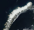
North Island Ice Cap (Novaya Zemlya)

Nordaustlandet with Austfonna

Vatnajökull (satellite image from NASA )
Peary Land with the Hans Tausen ice cap

Southern Patagonian Ice Field ( ISS photo)
Northern Patagonian Ice Field

Langjokull in Iceland

Hofsjokull in Iceland

Mýrdalsjökull in Iceland


