Northeast Country
| Nordostland (Nordaustlandet) | |
|---|---|
| Satellite image of Northeast Country | |
| Waters | Arctic Ocean |
| Archipelago | Svalbard |
| Geographical location | 79 ° 48 ' N , 22 ° 24' E |
| length | 170 km |
| width | 125 km |
| surface | 14,443 km² |
| Highest elevation | North Domen 770 m |
| Residents | uninhabited |
| Map of Northeast Country | |
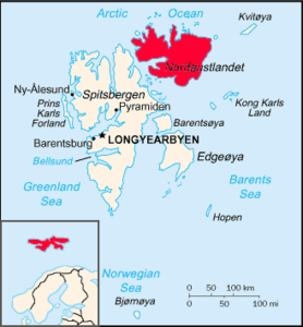
Northeast Country ( Norwegian Nordaustland ), with an area of 14,443 square kilometers, the second largest island of the state of Norway belonging Spitsbergen -Archipels (norw. Svalbard) in the Arctic Ocean . It is located northeast of the island of Spitzbergen (the main island of the archipelago) and is separated from it by the Hinlopen Strait . It is uninhabited, with the exception of a few researchers who stay there temporarily.
climate
As in the entire Svalbard Archipelago, the climate is highly Arctic, in line with the high geographical latitude. The north coast of the island is, however, under the slight influence of the West Spitsbergen Current (the last northern branch of the warm Gulf Stream ) and is therefore ice-free earlier in summer than the east and south, which are influenced by the cold East Spitsbergen Current . In general, however, the annual mean temperatures in northeastern land are much lower than in the west of the Svalbard archipelago.
geology
The northern half of the island consists almost entirely of basement rock. On the one hand, these are weakly metamorphic sediments ( quartzite , dolomite , limestone , slate ) from the younger Proterozoic (600 to 700 million years old), which were severely deformed by recent tectonic movements, so that the layers are steep in many places and crisscrossed by fractures and folds are. On the other hand, there are highly metamorphic gneisses as well as granite and other igneous rocks from the time of the Caledonian mountain formation (approx. 410 to 510 million years ago). In the south of the island there are foothills of the basalt intrusions from the Upper Jurassic and Lower Cretaceous , which are 100 to 150 million years old.
landscape
Nordostland forms a clear contrast to most of the other landscapes in Svalbard, which are comparatively strongly structured by mountains, valleys and fjords . The island is generally very spacious. In the north, extensive plateau mountain and hilly landscapes prevail, individual mountains are more the exception. The heights are mostly below 400 m, often below 300 m. The island reaches its greatest height at 770 m in the north dome. The plateaus often fall in steep rocky slopes to the more or less flat areas at sea level or directly into the sea.
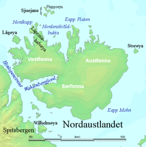
11,500 km² of the area of north-eastland is covered with ice caps and glaciers, which corresponds to 80% of the total area. The Austfonna ice cap, which is up to 430 meters thick and 8,450 km² in size, is the fourth largest inland ice area in the world after Antarctica and Greenland and the north island of Novaya Zemlya . Its edge in the sea is 190 km in length and is the longest in the northern hemisphere. With an area of 2450 km², Vestfonna is the second large ice cap on northeastern land.
Northeast is divided into five regions or landscapes:
- Gustav-V-Land (northwest)
- Prins Oscars Land (North)
- Orvin Land (northeast)
- Harald-V-Land (east, not shown on the map)
- Gustav-Adolf-Land (south, not shown on the map)
Flora and fauna
flora
The tundra of the northeast is very barren. Above all, flowering plants are only sparsely available in large areas, although sometimes a surprising number of flowers can be found in protected areas. So far, a total of 83 different vascular plant species have been found on northeastern land; even in the most northerly places, such as the Reliktbukta or Minebukta , still occur occasionally in wetter areas, mostly on moss underlay, sweet grasses and polar birches . Lichen, on the other hand, is rich in species and takes up large parts of the rock surface. Even algae form everywhere wide, blue-black coatings on the wet tundra soil.
fauna
The vegetation is sufficient to feed individual Svalbard reindeer on almost all ice-free areas . Polar bears and arctic foxes constantly roam the drift ice and tundra, and some species of birds, such as the sandpiper , kittiwake and snow bunting , breed on the island. There are also five species of spiders and 34 species of springtail . There are walrus resting places.
history
Due to the almost always very difficult ice conditions in the past, the eastern areas of the island in particular were only roughly known until the 20th century, and even today the waters in these regions are often unmeasured and therefore hardly accessible. The north-west of the north-east (which the Gulf Stream is more likely to clear of the ice), on the other hand, was already broadly known to the earlier whalers , although the region has never developed into a classic fishing area. Several well-known polar expeditions such as Phipps (1773) and Parry (1827) came to the north northeast of the country, but cared little about land and island. In 1861, the Swedish geologist Otto Torell initiated an excursion of several weeks along the north coast of northeastern country, so that at least an overview of the geology and topography of the areas visited was then available. The Englishman Benjamin Leigh Smith advanced to the northeasternmost point of the island in 1871 and 1873, and also in 1873 Adolf Erik Nordenskiöld traveled with the sledge for the first time through parts of the inner northeast. In 1899–1902 the Russian-Swedish degree measurement expeditions established a trigonometric network for parts of the north-west of the island. On August 15, 1912, Herbert Schröder-Stranz was dropped off with three companions between the North Cape and Cape Platen to cross the island with dog sleds . Her further fate is still unclear today. In 1928 Umberto Nobile and the crew of his airship crashed north of Nordostland, whereupon large-scale search expeditions were started. This search contributed significantly to the geographical knowledge of the north of the island. In the spring of 1929 Karl Bengtssen and two companions crossed the northern northeastern country from west to east on sledges. Systematic aerial photography , the basis of topographical mapping, was not carried out until 1939 by Norway. During the Second World War, the German naval weather station Haudegen was located on northeastern land . This surrendered on September 11, 1945 as the last German unit.
tourism
Visits by tourists are rare on Nordaustland. They are mostly offered as part of so-called expedition cruises, with the Wahlenbergfjord being used on the Spitsbergen circuit, a classic route for cruise ships . If anything, landings are made there. Another route runs along the north coast via Sjuøyane and then via Kvitøya around the entire Svalbard archipelago, with the exception of Bear Island and Hopen .
Northeast Svalbard Nature Reserve
Nordostland is entirely located in the Northeast Svalbard Nature Reserve, founded in 1973 . Any technical intervention (construction of buildings, operation of mines, etc.), any leaving of rubbish and any disturbance or introduction of animals and plants is prohibited. In addition, motorized vehicles are not allowed to enter the country. A permit from the Sysselmann is required to enter , and areas can also be completely closed to visitors.
Web links
- Svalbard-Images.com (including pictures from northeastern country)
- Map of Northeast Country


