
Hinlopenstrasse
| Hinlopenstrasse | ||
|---|---|---|
_2.jpg) |
||
| Connects waters | Arctic Ocean | |
| with water | Barents Sea | |
| Separates land mass | Spitsbergen | |
| of land mass | Northeast Country | |
| Data | ||
| Geographical location | 79 ° 37 ′ N , 18 ° 47 ′ E | |
|
||
| length | 150 km | |
| Smallest width | 8.7 km | |
| Greatest depth | > 400 m | |
| Islands | Wilhelmøya , Wahlbergøya , Bastianøyane , Vaigattøyane , Von Otterøyane , Rønnbeckøyane | |
 |
||


The Hinlopenstrasse ( Norwegian Hinlopenstretet or Hinlopenstredet ) is a strait of the Barents Sea in the Svalbard Archipelago between the islands of Svalbard and Nordostland .
geography
The Hinlopenstrasse is 150 km long, between 10 and 60 km wide and extends from Cape Payer in the south to Verlegenhuken in the north. It is over 400 m deep and divided into a series of basins by several thresholds. In its southern part it contains numerous islands. The passage is difficult because of the pack ice that is often found here .
The coastline of the Hinlopenstrasse is interrupted by several fjords , some of which cut deep into the bounding mainland. These are the Murchison and Wahlenberg fjords in the east and the Sorg and Lomfjords in the west. Some large glaciers calve into the Hinlopenstrasse, including the Etonbreen and the largest outlet glacier in Spitzbergen with 1248 km² , the Hinlopenbreen .
Flora and fauna
The flora on the coasts and on the islands of the Hinlopenstrasse is sparse. Most of the areas are cold deserts . The dominant plant is the Spitzberg poppy ( Papaver dahlianum ). In the tundra at Lomfjorden, Murchisonfjorden and Wahlenbergfjorden the arctic grove ( Luzula nivalis ) is common. Mosses and lichens are also represented.
There are some larger seabird colonies , especially on the west side of the strait. The largest is on Alkefjellet south of Lomfjorden. Hundreds of thousands of kittiwakes and thick-billed lemurs breed on the dolerite rock in spring and summer . You can also find fulmars , crab grebes , black guillemots and eider ducks in the area of Hinlopenstrasse . The arctic fox can also be found near the bird colonies . Walruses can be found in the Augustabukta and Vibebukta . Even polar bears are fairly common. In 1995 there was a tragic incident on Kiepertøya, one of the Bastian Islands, in which a polar bear killed a person.
The Hinlopenstrasse has been part of the Northeast Svalbard Nature Reserve since 1973 .
history
The street is probably named after the head of the Nordic Company Tymen J. Hinlopen (1572–1637). It was visited early on by whalers and pomors . In 1827 Henry Foster mapped the northern part and found a good match with Dutch maps from the beginning of the 18th century. On the First German North Polar Expedition in 1868, Carl Koldewey traveled the Hinlopen Strait with Greenland . Numerous geographical names go back to this expedition, such as Bastianøyane , Wilhelmøya and Augustabukta.
gallery

Cape Fanshawe
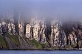
Alkefjellet
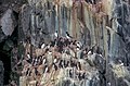
Alkefjellet

Olympics
_1.jpg)
_3.jpg)
_8.jpg)
.jpg)
Individual evidence
- ↑ S. Pfirman, JD Milliman: Morphology, geology and oceanography of the Hinlopen Strait and Trough, Svalbard, Norway . In: Polar Research 5 (3), 1987, pp. 297-298
- ^ Olav Liestøl: Glaciers of Svalbard, Norway. (PDF; 2.8 MB) In: Richard S. Williams Jr., Jane G. Ferrigno (eds.): Satellite Image Atlas of Glaciers of the World - Europe, 1993
- ↑ Hinlopenstretet's vegetation on the Norwegian Polar Institute website , accessed on November 7, 2010
- ↑ a b Hinlopenstretet’s wildlife on the website of the Norwegian Polar Institute (English), accessed on November 7, 2010
- ↑ Hinlopenstretet's history on the website of the Norwegian Polar Institute (English), accessed on September 13, 2010
Web links
- Hinlopenstraße at www.spitzbergen.de
- Step down . In: The Place Names of Svalbard (first edition 1942). Norsk Polarinstitutt , Oslo 2001, ISBN 82-90307-82-9 (English, Norwegian).