Barents Sea
| Barents Sea | |
|---|---|
| Location of the Barents Sea | |
| Art | Side sea |
| ocean | Northern ocean |
| location | Between Spitsbergen , Franz-Josef-Land , Novaya Zemlya and the northern coast of Europe |
| Tributaries | Iokanga , Kola , Paatsjoki , Sapadnaja Liza , Tanaelva , Tuloma , Titowka , Teriberka , Voronja |
| Important islands | Kolgujew , Bear Island , Hopen |
| Cities on the shore | Murmansk |
| Data | |
| surface | 1,405,000 km² ( Encyclopedia Britannica ) |
| volume | 322,000 km³ |
| Maximum depth | 600 m (Encyclopedia Britannica) |
| Middle deep | 229 m (Encyclopedia Britannica) |
| Border to the European Arctic Ocean | |
Coordinates: 75 ° N , 40 ° E
The Barents Sea is a marginal sea of the Arctic Ocean ( Arctic Ocean ) north of Norway and the European part of Russia . It was named after the Dutch navigator Willem Barents . With an average depth of 230 m, it is one of the deeper shelf seas . The North Atlantic Current , an extension of the Gulf Stream , ensures that many ports on the Barents Sea are ice-free all year round, even though they are far to the north. In September the Barents Sea is completely free of ice. Due to the comparatively high water temperature, biomass production is significantly higher than in other seas of comparable geographic latitude. In spring, the algal bloom begins with the production of phytoplankton , followed by zooplankton , which in turn is the food source of fish, sea birds and marine mammals.
Oceanography
There are three different water masses in the Barents Sea: warm and salty surface water from the North Atlantic Current (temperature> 3 ° C, salinity > 35 ‰), cold polar water (temperature <0 ° C, salinity <35 ‰) and warm, low-salt coastal water ( Temperature> 3 ° C, salinity <34.7 ‰). The separation between the water masses of the Atlantic Current and the polar water is known as the polar front, which is fairly constant and sharply delimited in the west near Bear Island due to the soil topography, but in the east near Novaya Zemlya is diffuse and subject to large fluctuations.
geography

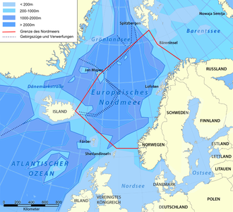
The Barents Sea lies between the archipelago of Spitsbergen (Norway) in the north-west, Franz-Josef-Land (Russia) in the north, Novaya Zemlya in the east and the mainland of north-west Russia and Scandinavia in the south. The boundary of the Barents Sea to the neighboring European North Sea to the west is a line from the island of Svalbard via Bear Island to the North Cape of Scandinavia . The connection between the Swjatoi Nos headlands on the Murman Coast and Cape Kanin in the north of the Kanin peninsula of the same name is defined as the border to the White Sea in the south . In the east, the Novaya Zemlya archipelago separates the Barents Sea from the Kara Sea .
During the Cold War and thereafter, the border of the territories in the Barents Sea between the Soviet Union and later Russia and Norway was disputed. So Russia recently insisted on drawing a border at around 32 ° East. In April 2010, Russia and Norway reached a contractual agreement on a compromise. Norway and Russia received roughly equal parts of the disputed marine area. It was divided by a center line that is now considered to be the common border in the Barents Sea.
Economy and ecology
The largest city on the Barents Sea is Murmansk , which, like the former Finnish Pechenga, houses a base for the Russian Northern Fleet .
The flat eastern part of the Barents contains rich petroleum resources and, after opening out there flow Petschora Pechora mentioned. There are also rich oil and natural gas deposits in the southwest, and further deposits are suspected in the central area. Oil has been produced in the Barents Sea since the 1970s.
Currently is in the Barents Sea by the company Statoil first European earth - or liquefied built -Förderanlage, the project Snøhvit (ie Snow White..). In the Snøhvit and Goliat gas fields , Statoil and Norsk Hydro are to use a new subsea conveyor technology that is currently being tested in the European Arctic Ocean, the Ormen-Lange gas field . A major natural gas liquefaction plant is being built at Hammerfest in Northern Norway.
Another important branch of the economy is the fishing industry, especially for Norway and Russia. Above all, the cod is caught here.
With a large number of often military ship cemeteries, the Barents Sea is probably the world's largest scrap yard for nuclear submarines . There were also a number of accidents and accidents, for example K-159 sank here on the way to being scrapped in 2003. The Kursk catastrophe occurred three years earlier .
literature
- ICES : ICES Advice 2007 . Book 3 - The Barents Sea and the Norwegian Sea , 2007, ices.dk (PDF)
- Gerald Traufetter: Raw materials. Elemental force from the depths . In: Der Spiegel . No. 29 , 2006, p. 116 ff . ( online ).
- M (oritz) Lindemann: The journeys of the "Willem Barents" in the European Arctic Ocean, 1878 and 1879 : In: Ernst Behm : Dr. A. Petermann's communications from Justus Perthes' Geographical Institute . Volume 26, 1880, ZDB -ID 2656552-3 . Perthes, Gotha 1880, pp. 18–21, full text.
- The Barents Sea . In: Robert Dinwiddie, Philip Eales, Sue Scott, Michael Scott: Ocean: The World's Last Wilderness Revealed . Dorling Kindersley, London 2006, ISBN 978-0-7566-3692-0 ( books.google.de )
- Gillian Lindsey: Barents Sea . In: Mark Nuttall (Ed.): Encyclopedia of the Arctic . Volume I, A-F. Fitzroy Dearborn Pub, 2004, pp. 200–201, ISBN 978-1-57958-437-5 ( books.google.de )
- Andrew J. Dog: Barents Sea . In: Andrew J. Hund (Ed.): Antarctica and the Arctic Circle: A Geographic Encyclopedia of the Earth's Polar Regions . Volume 1, A-I. ISBN 978-1-61069-392-9 , p. 129
Web links
- Barentswatch - a collection of various cards
- Cryosphere - Maps of the sea ice distribution of the polar regions, current data and archive data
- Foraminifera of the Barents Sea - illustrated catalog
Individual evidence
- ↑ Norway and Russia end dispute over the Barents Sea . NZZ , April 27, 2010

