
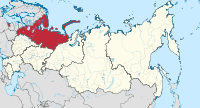
Northwest Russia
| Northwestern Federal District | |
|---|---|
  |
|
| Area : | 1,686,968 km² |
| Residents : | 13,616,057 (2010) |
| Population density : | 8.1 inhabitants / km² |
| Administrative headquarters : | St. Petersburg |
The Northwestern Federal District ( Russian: Северо-западный федеральный округ ; Severo-sapadny federalny okrug, literally North-Western Federal District ) is an administrative unit ( federal district ) in Russia . The administrative seat is in Saint Petersburg .
geography
Northwestern Russia encompasses northern Russia from the Ural Mountains in the east to the Kola Peninsula in the northwest, as well as the extreme west of the European part of the Russian Federation, which borders the Baltic Sea , the White Sea and the Arctic Ocean . In addition, the non-connected by road with the rest of Russia's exclave of Kaliningrad Oblast . The arctic island groups Novaya Zemlya and Franz-Josef-Land also belong to the federal district .
Northwestern Russia borders in the south on the federal districts of Central Russia and Volga , in the east on the federal district of Urals . State borders exist with Poland , Belarus , Lithuania , Latvia , Estonia , Finland and Norway . During the last Ice Age, a large part of northwestern Russia was covered by a thick sheet of ice. When the ice retreated, thousands of glacial lakes formed and shape the landscape to this day. The largest of these lakes are Lake Ladoga , Lake Onega , Lake Peipus , Lake Ilmen and Lake White . The longest river is the 744 kilometers long Northern Dvina , which flows into the White Sea at Arkhangelsk . The short but water-rich Swir connects Lake Onega with Lake Ladoga and flows into the Neva to St. Petersburg in the Gulf of Finland . The White Sea-Baltic Canal connects the White Sea with Lake Onega. Shipping has therefore been possible between the Arctic and the Baltic Sea since the 1930s.
The relief of the circle is flat in the south and west and hilly in the north. On the Kola Peninsula , the peaks of the tundra-shaped and treeless Chibinen - a circular low mountain range - reach heights of up to 1200 meters. The Narodnaya in the far north-east of the district is the highest mountain in the Urals at 1,895 meters and at the same time the highest elevation in the federal district.
The air is up to the temperate south-west and the Arctic north kaltgemäßigt , humid and continental and forms the boreal zone . Winters generally last longer than five months, while the days are short and only allow around five to six hours of daylight on average. In Murmansk , which is north of the Arctic Circle , there are all day polar nights in winter . This phase lasts from the beginning of December to mid-January. In summer, however, the white nights are typical for this region. St. Petersburg is characterized by a year-round humid maritime climate . The coldest temperature ever recorded in St. Petersburg is -36 ° C, the warmest 33 ° C.
The vast majority of the country is dominated by taiga forests . Mixed deciduous forests occur only in the Kaliningrad exclave. Around the Arctic Circle, the forest changes into the light forest tundra , which is shaped by the Fennoscan mountain birch to the west of the White Sea and by the Siberian spruce to the east as far as the Urals .
It should be emphasized that by far the largest intact wilderness regions in Europe are in north-west Russia : at the beginning of the 21st century, according to a study by the Wildlife Conservation Society from 2005, there is still at least one third ("core wilderness - most wild") and a maximum of two thirds (" Wilderness character - Last of the wild ”) of the land area in a natural state. Almost half of the core wilderness is in boreal forest areas, of which almost 12 percent have so far been adequately protected and the existence of which is considerably endangered by significant felling.
With almost 1,700,000 square kilometers, the federal district occupies almost a tenth of the total area of Russia, as does the population of a good 13.6 million (2010) of the total population. The population density is about the same as for the whole of Russia. At the 2010 census, the population of the areas of the federal district had fallen by about 11% compared to the 1989 census; however, it has been rising again since 2009. With a share of 82 percent of city dwellers, Northwestern Russia has the most urbanized population of all federal districts. However, the population distribution is very uneven and is mainly concentrated around St. Petersburg. In contrast, the autonomous district of the Nenets has an area of 177,000 km² and a population of only 43,000.
Other major cities in the federal district in addition to the administrative center, the metropolis of Saint Petersburg, are Kaliningrad , Arkhangelsk , Tscherepowez , Vologda , Murmansk , Petrozavodsk , Syktywkar , Veliky Novgorod , Pskow and Severodvinsk (in descending order according to population in 2010).
structure
.svg)
|
||||||
|---|---|---|---|---|---|---|
| # | flag | Federation subject | Capital / Administrative Center | surface | Population 2010 | Population 2015 |
| 1 |
|
Arkhangelsk Oblast | Arkhangelsk | 589,913 km² | 1.227 million | 1.183 million |
| 2 |
|
Vologda Oblast | Vologda | 144,527 km² | 1.202 million | 1.191 million |
| 3 |
|
Kaliningrad Oblast | Kaliningrad | 15,125 km² | 0.941 million | 0.968 million |
| 4th |
|
Republic of Karelia | Petrozavodsk | 180,520 km² | 0.643 million | 0.632 million |
| 5 |
|
Republic of Komi | Syktyvkar | 416,774 km² | 0.901 million | 0.864 million |
| 6th |
|
Leningrad Oblast | 83,908 km² | 1.716 million | 1.775 million | |
| 7th |
|
Murmansk Oblast | Murmansk | 144,902 km² | 0.795 million | 0.766 million |
| 8th |
|
Autonomous Okrug of the Nenets | Naryan-Mar | 176,810 km² | 0.042 million | 0.043 million |
| 9 |
|
Novgorod Oblast | Veliky Novgorod | 54,501 km² | 0.634 million | 0.618 million |
| 10 |
|
Pskov Oblast | Pskov | 55,399 km² | 0.673 million | 0.651 million |
| 11 |
|
St. Petersburg | 1,439 km² | 4,879 million | 5.191 million | |
| total | 1,686.968 km² | 13.616 million | 13.843 million | |||
economy
The Northwestern Federal District plays an important role in Russia's economic life - both because of its geographical location and its special economic structure. Mechanical engineering , chemical , light and food industries as well as the oil industry , forestry and fishing are traditionally the most important branches of the district. The IT industry in St. Petersburg has recently developed dynamically . In addition, the transport industry and logistics , telecommunications, shipbuilding and the service industry make up an important part of the economic structure in northwest Russia.
The circle ranks number one in the production of apatite and nepheline concentrate (100 percent of the total production volume in Russia). The district has a large share in the total Russian production of paper (over 60 percent), cardboard (over 50 percent), TV sets (over 50 percent), canned fish (around 60 percent) and tea . St. Petersburg is the economic center of north-west Russia. Many mechanical engineering, shipbuilding and food processing companies are located here.
The Leningrad Oblast is increasingly developing into a center of the automobile and motor vehicle supply industry. In the autonomous district of the Nenets, oil and natural gas are produced . The Severstal steel group is based in the Vologda Oblast . In the infrastructure sector, the largest road construction project in Russia in the recent past was realized with the ring road around St. Petersburg . The expansion of the Ust-Luga port is just as important .
Individual evidence
- ^ Study "Last of the wild - Version 2" on the website "Socioeconomic Data and Applications Center (SEDAC)" of the "Center for International Earth Science Information Network (CIESIN)" at Columbia University, New York - query September 2012 -and- Mark Fisher et al .: Review of Status and Conservation of Wild Land in Euope. Report on behalf of the Government of Scotland, The Wildand Research Institute, Leeds (UK) November 2010., pp. 53-63, 70-72, Appendix A-3, A-4 and others. a. ( pdf ) - both in comparison with the mapped sources of the Commons-Map Wilderness-and-protected-areas-of-europe, -beginning-21st-century.jpg as well as with protectetplanet.net/Russian Federation and other sub -pages , accessed on 19th January 2019.
- ↑ Peter Potapov et al .: The last frontiers of wilderness: Tracking loss of intact forest landscapes from 2000 to 2013. , January 13, 2017 in ScienceAdvances 2017, 3 :. doi: 10.1126 / sciadv.1600821 , pp. 3-5 and a.
- ↑ Alexey Yu. Yaroshenko, Peter V. Potapov, Svetlana A. Turubanova: The Last Intact Forest Landscapes of Northern European Russia . Greenpeace Russia 2001. pp. 61–75 (conversion compared with the 2018 data in protectplanet.net, Russia ), both accessed on January 17, 2019.
- ↑ Оценка численности постоянного населения на 1 января 2015 года и в среднем за 2014 год (опубликоварда) 17. Проверено 18 марта 2015. Архивировано из первоисточника 18 марта 2015.