
Republic of Komi
|
Subject of the Russian Federation
Republic of Komi
Республика Коми Коми Республика
|
||||||||||||||||||||||||||||||||||||
  |


Coordinates: 63 ° 48 ' N , 55 ° 48' E
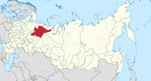
The Republic of Komi ( Russian Республика Коми , Komi Коми Республика) is a federal subject of Russia in the federal district of Northwestern Russia .
geography
The Komi Republic is located in the far northeast of Europe , a sparsely populated taiga and tundra region. The landscape is mainly flat, in the northwest lies the Timan Ridge , in the east it borders on the Ural Mountains . The most important rivers are the Pechora and the Wytschegda , a tributary of the Northern Dvina . The primeval forests of Komi are the largest contiguous primeval forest area in Europe and have been a UNESCO World Heritage Site since 1995 . The Manpupunjor Rocks are one of the Seven Wonders of Russia .
Cities

The most important place and currently the only major city is the capital Syktyvkar . Other large towns are Ukhta , Vorkuta , which has become known primarily as a penal colony , Pechora , Ussinsk and Inta .
| Surname | Russian name | Name in Komi | Resident October 14, 2010 |
|---|---|---|---|
| Syktyvkar | Сыктывкар | Сыктывкар | 235.006 |
| Uchta | Ухта | Уква | 99,591 |
| Vorkuta | Воркута | Вӧркута | 70,548 |
| Pechora | Печора | Печӧра | 43.105 |
| Ussinsk | Усинск | Ускар | 40,827 |
| Inta | Инта | Инта | 32,080 |
| Sosnogorsk | Сосногорск | Сӧснагорт | 27,757 |
population
The Komi are a Finno-Ugric people. Until the Soviet era, they lived almost among themselves. From the Stalin era to the end of the Soviet Union, both the number of inhabitants and the ethnic composition of the population changed dramatically. In addition to deportees, members of all Soviet peoples came to the area for economic reasons. The Komi became a minority in their own country. Russians make up the majority of the population today. Other important ethnic groups are the Ukrainians , Tatars , Belarusians , Russian Germans and Chuvashes . Azerbaijanis , Bashkirs (3,149 people in 2002), Moldavians (3,447 people in 2002), Mari , Lithuanians , Udmurts and Uzbeks also settled in their thousands. After the collapse of the Soviet Union , many immigrants returned to their home regions. Therefore, the population decreased from 1989 to 2010 by 349,658 people or 28%.
The official languages are Komi and Russian . The majority of the population professes Russian Orthodox Christianity .
| Ethnic group | VZ 1926 1 | VZ 1939 | VZ 1959 | VZ 1970 | VZ 1979 | VZ 1989 | VZ 2002 | VZ 2010 2 | ||||||||
|---|---|---|---|---|---|---|---|---|---|---|---|---|---|---|---|---|
| number | % | number | % | number | % | number | % | number | % | number | % | number | % | number | % | |
| Komi | 191,245 | 92.2% | 231,301 | 72.5% | 245,074 | 30.4% | 276.178 | 28.6% | 280,798 | 25.3% | 291,542 | 23.3% | 256.464 | 25.2% | 202.348 | 22.5% |
| Russians | 13,731 | 6.6% | 70.226 | 22.0% | 389.995 | 48.4% | 512.203 | 53.1% | 629.523 | 56.7% | 721.780 | 57.7% | 607.021 | 59.6% | 555.963 | 61.7% |
| Ukrainians | 34 | 0.0% | 6,010 | 1.9% | 80.132 | 9.9% | 82,955 | 8.6% | 94.154 | 8.5% | 104,170 | 8.3% | 62,115 | 6.1% | 36,082 | 4.0% |
| Tatars | 32 | 0.0% | 709 | 0.2% | 8,459 | 1.0% | 11,906 | 1.2% | 17,836 | 1.6% | 25,980 | 2.1% | 15,680 | 1.5% | 10,779 | 1.2% |
| Belarusians | 11 | 0.0% | 3,323 | 1.0% | 22,339 | 2.8% | 24,706 | 2.6% | 24,763 | 2.2% | 26,730 | 2.1% | 15,212 | 1.5% | 8,889 | 1.0% |
| German | 15th | 0.0% | 2,617 | 0.8% | 19,805 | 2.5% | 14,647 | 1.5% | 13,339 | 1.2% | 12,866 | 1.0% | 9,246 | 0.9% | 5,441 | 0.6% |
| Tschuwaschen | 3 | 0.0% | 246 | 0.1% | 3,493 | 0.4% | 6,567 | 0.7% | 8,545 | 0.8% | 11,253 | 0.9% | 7,529 | 0.7% | 5,077 | 0.6% |
| Azerbaijanis | 0 | 0.0% | 112 | 0.0% | 1,374 | 0.2% | 950 | 0.1% | 2.158 | 0.2% | 4,728 | 0.4% | 6,066 | 0.6% | 4,858 | 0.5% |
| Nenets | 2,080 | 1.0% | 508 | 0.16% | 374 | 0.05% | 369 | 0.04% | 366 | 0.03% | 376 | 0.03% | 708 | 0.07% | 503 | 0.06% |
| Other | 163 | 0.1% | 3,944 | 1.2% | 35,154 | 4.4% | 34,321 | 3.6% | 38,879 | 3.5% | 51,422 | 4.1% | 38,633 | 3.8% | 71,249 | 7.9% |
| Residents | 207.314 | 100% | 318.996 | 100% | 806.199 | 100% | 964.802 | 100% | 1,110,361 | 100% | 1,250,847 | 100% | 1,018,674 | 100% | 901.189 | 100% |
| 1 area at that time; 2 46,886 people could not be assigned to any ethnic group. These people are probably distributed in the same proportion as the ethnically classified inhabitants. | ||||||||||||||||
Composition of the population according to ethnic groups and territorial units of the Komi Republic according to the 2010 census
The decline in the proportion of ethnic Komi in the total population in the last census period (2002-2010) is particularly noticeable and is due to increasing assimilation (among other things through mixing of the population groups, i.e. marriages between Komi and Russians, whereby the children resulting from these connections mostly grow up Russian-speaking). Ethnic Komi make up the largest population group in only five of the 20 territorial units (urban districts or Rajons) of the Komi Republic. These are exclusively sparsely populated rural areas, while the Russians are by far the largest group in the larger cities .
| Rajon (city) |
Komi | Russians | Ukrainians | Tatars | Belarusians | German | Tschuwaschen | Bashkirs | Azerbaijanis |
|---|---|---|---|---|---|---|---|---|---|
| Syktyvkar city | 25.9% | 66.0% | 2.8% | ... | ... | ... | ... | ... | ... |
| City of Vorkuta | 1.7% | 77.7% | 7.9% | 2.9% | 1.5% | ... | 1.1% | ... | 1.0% |
| Wuktyl district | 10.8% | 72.3% | 8.3% | 1.6% | 1.4% | ... | 1.2% | ... | ... |
| City district Inta | 11.4% | 72.6% | 7.6% | 1.8% | 1.4% | ... | ... | ... | ... |
| Pechora district | 13.2% | 74.7% | 5.7% | ... | 1.4% | ... | ... | ... | ... |
| Sosnogorsk city district | 8.9% | 80.8% | 4.3% | ... | 1.2% | ... | ... | ... | ... |
| Ussinsk city district | 14.8% | 59.6% | 7.6% | 7.2% | 1.5% | ... | 1.0% | 2.5% | 1.5% |
| Uchta city district | 7.9% | 81.1% | 4.1% | 1.1% | 1.1% | ... | ... | ... | ... |
| Ishemsky rajon | 88.9% | 9.7% | ... | ... | ... | ... | ... | ... | ... |
| Knjaschpogostski rajon | 15.3% | 70.4% | 5.4% | ... | 1.7% | ... | ... | ... | 1.3% |
| Koigorodski rajon | 35.5% | 56.1% | 3.0% | ... | ... | 1.9% | ... | ... | ... |
| Kortkerosski rajon | 68.4% | 26.8% | 1.9% | ... | ... | ... | ... | ... | ... |
| Syktyvdinsky rajon | 45.9% | 47.6% | 2.3% | ... | ... | ... | ... | ... | ... |
| Syssolski rajon | 64.8% | 29.7% | 1.9% | ... | ... | ... | ... | ... | ... |
| Prilussky rajon | 55.2% | 40.9% | 1.6% | ... | ... | ... | ... | ... | ... |
| Troitsko-Pechorsky rajon | 26.2% | 63.9% | 4.3% | ... | 1.4% | ... | ... | ... | ... |
| Udorski rajon | 40.3% | 46.7% | 3.8% | ... | 1.0% | ... | ... | ... | ... |
| Ust-Wymski rajon | 25.6% | 62.8% | 4.4% | ... | 1.1% | ... | ... | ... | ... |
| Ust-Kulomski rajon | 76.9% | 18.9% | 1.7% | ... | ... | ... | ... | ... | ... |
| Ust-Zilemski rajon | 5.1% | 93.0% | ... | ... | ... | ... | ... | ... | ... |
Administrative division
The Komi Republic is divided into five city districts and 15 Rajons (districts).
history
).jpg)
The Russians began to settle the area in the late Middle Ages . In 1921 the Komi Autonomous Oblast was formed within the Russian SFSR , which in 1936 became the Komi ASSR . After the collapse of the Soviet Union in late 1991, Komi became a subject of the Federation of Russia.
From 2010 to September 19, 2015 Vyacheslav Gaiser was head of the republic. He was dismissed and arrested on corruption charges.
Economy and Transport
The most important traffic axis is the Pechora Railway from Moscow to Vorkuta . Forestry is practiced on a large scale. The area is rich in mineral resources, especially coal, petroleum, natural gas and iron ore.
Russia's first oil production facility was put into operation in 1745 on the territory of today's Komi Republic, on the Ukhta River . However, oil production on an industrial scale did not begin until the middle of the 20th century and was expanded significantly by the Soviet Union , especially from the 1960s / 1970s .
environment
One of Russia's oldest environmental movements can be found in the region. It was founded in the 1980s and campaigned for the rehabilitation of leaky oil pipelines. Thanks to her, the nuclear tests on Novaya Zemlya are said to have been stopped and she had resisted test drillings from Lukoil .
Oil pipelines in northern Russia are particularly heavily polluted due to the large temperature differences from summer to winter and the permafrost soil that thaws in summer . During the 1990s, due to the turmoil of privatization, thousands of leaky pipelines were not repaired, causing environmental damage. In 1994 more than 100,000 tons of crude oil ran into the tundra near Ussinsk and contaminated the soil and the Kolva and Pechora rivers .
Web links
Individual evidence
- ↑ Administrativno-territorialʹnoe delenie po subʺektam Rossijskoj Federacii na 1 janvarja 2010 goda (administrative-territorial division according to subjects of the Russian Federation as of January 1, 2010). ( Download from the website of the Federal Service for State Statistics of the Russian Federation)
- ↑ a b Itogi Vserossijskoj perepisi naselenija 2010 goda. Tom 1. Čislennostʹ i razmeščenie naselenija (Results of the All-Russian Census 2010. Volume 1. Number and distribution of the population). Tables 5 , pp. 12-209; 11 , pp. 312–979 (download from the website of the Federal Service for State Statistics of the Russian Federation)
- ↑ Nacional'nyj sostav naselenija po sub "ektam Rossijskoj Federacii. (XLS) In: Itogi Vserossijskoj perepisi naselenija 2010 goda. Rosstat, accessed on June 30, 2016 (Russian, ethnic composition of the population according to federal subjects , results of the 2010 census).
- ^ Population of Russian territorial units by nationality 2010 (Russian; lines 202–217) gks.ru
- ↑ http://www.aktuell.ru/russland/panorama/antikorruptions_kampagne_zar_gegen_gaiser_3827.html
- ↑ Alec Luhn: The town that reveals how Russia spills two Deepwater Horizons of oil each year . In: The Guardian . 5th August 2016.
- ↑ "We are from a single Soviet people" , Novaya Gazeta, December 21, 2017
- ↑ https://urgentcomm.com/2000/03/01/oil-on-the-tundra-a-spill-in-the-komi-republic/
- ↑ Julia Ponomarewa: Leaks on Russian oil pipelines Russia beyond the headlines, In: The Moscow News. August 30, 2012.
- ^ JR McNeill: The Great Acceleration . Harvard University Press, 2016, ISBN 978-0-674-97074-8 ( google.de ).
Republics: Adygea | Altai | Bashkortostan | Buryatia | Khakassia | Dagestan | Ingushetia | Kabardino-Balkaria | Kalmykia | Karachay-Cherkessia | Karelia | Komi | Crimea 1 | Mari El | Mordovia | North Ossetia-Alania | Sakha (Yakutia) | Tatarstan | Chechnya | Chuvashia | Tuva | Udmurtia
Regions ( Krai ): Altai | Khabarovsk | Kamchatka | Krasnodar | Krasnoyarsk | Perm | Primorye | Stavropol | Transbaikalia
Areas ( Oblast ): Amur | Arkhangelsk | Astrakhan | Belgorod | Bryansk | Irkutsk | Ivanovo | Yaroslavl | Kaliningrad | Kaluga | Kemerovo | Kirov | Kostroma | Kurgan | Kursk | Leningrad | Lipetsk | Magadan | Moscow | Murmansk | Nizhny Novgorod | Novgorod | Novosibirsk | Omsk | Orenburg | Oryol | Penza | Pskov | Ryazan | Rostov | Sakhalin | Samara | Saratov | Smolensk | Sverdlovsk | Tambov | Tyumen | Tomsk | Chelyabinsk | Tula | Tver | Ulyanovsk | Vladimir | Volgograd | Vologda | Voronezh
Cities with subject status: Moscow | Saint Petersburg | Sevastopol 1
Autonomous Oblasts: Jewish Autonomous Oblast
Autonomous circles : Khanty and Mansi / Ugra | Yamal-Nenets | Nenets | Chukchi
1 Internationally Disputed Areas