
Mari El
|
Subject of the Russian Federation
Republic of Mari El
Республика Марий Эл ( Russian ) Марий Эл Республик ( Wiesenmari ) Мары Эл Республик ( Bergmari )
|
||||||||||||||||||||||||||||||||||||
  |


Coordinates: 56 ° 30 ' N , 48 ° 0' E
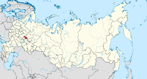
The Republic of Mari El ( Russian Республика Марий Эл , Bergmari Мары Эл Республик , Wiesenmari Марий Эл Республик , translated “the country of Mari”) is an autonomous republic in the eastern part of European Russia . It lies on the central reaches of the Volga in the area of the Cheboksarsk Reservoir and extends between 400 and 800 km east of Moscow , about halfway to the Urals .
geography

Most of the republic is north of the Volga, east of Nizhny Novgorod Oblast and northwest of Tatarstan and its city of Kazan . In the south it borders on the autonomous republic of Chuvashia , which is already on the right side of the Volga.
population
The titular nation is the Mari , a Finno-Ugric people who were formerly known as the "Cheremissi". They speak two related languages, mountain and meadow mari . Just behind the Russians, the Mari are the second largest ethnic group in the republic. Only about half of all Mari live in their republic. In addition to Mari and Russians, the Tatars are another important nationality in Mari El. Smaller minorities are the Chuvashes and Ukrainians . The area has been declining in population since 1989. This was 52,873 people (1989-2010) or around 7%.
The official languages are both Mari languages and Russian . In terms of religion, the Russian Orthodox Church predominates (66 parishes), there are also followers of ethnic religions (3 communities), Muslims (14 associations) and Protestants (42 parishes).
| Ethnic group | VZ 1926 | VZ 1939 | VZ 1959 | VZ 1970 | VZ 1979 | VZ 1989 | VZ 2002 | VZ 2010 2 | ||||||||
|---|---|---|---|---|---|---|---|---|---|---|---|---|---|---|---|---|
| number | % | number | % | number | % | number | % | number | % | number | % | number | % | number | % | |
| Mari 1 | 247.979 | 51.4% | 273,332 | 47.2% | 279,450 | 43.1% | 299.179 | 43.7% | 306,627 | 43.5% | 324,349 | 43.3% | 312.178 | 42.9% | 290,863 | 41.8% |
| Russians | 210.016 | 43.6% | 266,951 | 46.1% | 309.514 | 47.8% | 320.825 | 46.9% | 334,561 | 47.5% | 355.973 | 47.5% | 345,513 | 47.5% | 313,947 | 45.1% |
| Tatars | 20,219 | 4.2% | 27,149 | 4.7% | 38,821 | 6.0% | 40.279 | 5.9% | 40,917 | 5.8% | 43,850 | 5.9% | 43,377 | 6.0% | 38,357 | 5.5% |
| Tschuwaschen | 2.184 | 0.5% | 5,504 | 0.9% | 9,065 | 1.4% | 9,032 | 1.3% | 8,087 | 1.1% | 8,993 | 1.2% | 7,418 | 1.0% | 6,025 | 0.9% |
| Ukrainians | 86 | 0.0% | 1,805 | 0.3% | 2,728 | 0.4% | 4,563 | 0.7% | 4,454 | 0.6% | 5,344 | 0.7% | 5,097 | 0.7% | 3,601 | 0.5% |
| German | 36 | 0.01% | 247 | 0.04% | 1,140 | 0.18% | 768 | 0.11% | 527 | 0.07% | 544 | 0.07% | 532 | 0.07% | 399 | 0.06% |
| Other | 1,581 | 0.3% | 4,622 | 0.8% | 6,962 | 1.1% | 10.102 | 1.5% | 9,034 | 1.3% | 10,279 | 1.4% | 13,864 | 1.9% | 43,267 | 6.2% |
| Residents | 482.101 | 100% | 579.610 | 100% | 647.680 | 100% | 684.748 | 100% | 704.207 | 100% | 749.332 | 100% | 727.979 | 100% | 696.459 | 100% |
| 1 Mari, Berg- und Wiesenmari (2002 17,715 and 2010 23,502 Bergmari) 2 34,129 people could not be assigned to any ethnic group. These people are probably distributed in the same proportion as the ethnically classified inhabitants. | ||||||||||||||||
Administrative divisions and cities

The republic is divided into 14 Rajons and three urban districts . The urban districts are formed by the capital Yoshkar-Ola , the only major city , and the only other cities with more than 20,000 inhabitants, Kosmodemjansk and Wolschsk . There are a total of four cities and 15 urban-type settlements in the republic .
| City / town settlement | Russian | Mari ** | Residents (October 14, 2010) |
|---|---|---|---|
| Yoshkar-Ola * | Йошкар-Ола | Йошкар-Ола | 248,782 |
| Wolschsk * | Волжск | Юлсер-Ола | 55,659 |
| Kosmodemyansk * | Козьмодемьянск | Чыкма ( Цикмӓ ) | 21,257 |
| Medvedevo | Медведево | Маскасола | 16,841 |
| Zvenigowo * | Звенигово | Провой | 11,946 |
| Sowetski | Советский | У Роҥго ( У Ронго ) | 10,664 |
Notes: * City ** Name on east or meadow mari; in brackets, if different, on West- or Bergmari
history

The area that the Mari inhabited was for a long time disputed between the Kazan Khanate and Russia and thus also between Islam and the Russian Orthodox Church. It finally came to Russia in the middle of the 16th century and has shared its history ever since. In 1936, the Mari Autonomous Soviet Socialist Republic (ASSR) was founded, from which the Mari El Republic emerged in 1991.
politics
Mari El is a presidential republic. The current president and head of government is Alexander Evstifeev . Four political groups are represented in parliament, the state assembly. There is a small national Mari movement . Your most important party is Mari Uschem.
economy
Mari El is located in the densely forested region ( taiga ), 57% of its area is covered by forest. Forestry is a correspondingly important branch of industry . Other branches of industry are mechanical engineering and electrical engineering.
Web links
Individual evidence
- ↑ Administrativno-territorialʹnoe delenie po subʺektam Rossijskoj Federacii na 1 janvarja 2010 goda (administrative-territorial division according to subjects of the Russian Federation as of January 1, 2010). ( Download from the website of the Federal Service for State Statistics of the Russian Federation)
- ↑ a b Itogi Vserossijskoj perepisi naselenija 2010 goda. Tom 1. Čislennostʹ i razmeščenie naselenija (Results of the All-Russian Census 2010. Volume 1. Number and distribution of the population). Tables 5 , pp. 12-209; 11 , pp. 312–979 (download from the website of the Federal Service for State Statistics of the Russian Federation)
- ↑ Nacional'nyj sostav naselenija po sub "ektam Rossijskoj Federacii. (XLS) In: Itogi Vserossijskoj perepisi naselenija 2010 goda. Rosstat, accessed on June 30, 2016 (Russian, ethnic composition of the population according to federal subjects , results of the 2010 census).
- ^ Hanka Kliesch: On the linguistic situation in the Republic of Mari El . (PDF) 2001, p. 15.
- ^ Population of the Russian territorial units by nationality 2010. ( MS Excel ) Lines 566–576 (Russian)
Republics: Adygea | Altai | Bashkortostan | Buryatia | Khakassia | Dagestan | Ingushetia | Kabardino-Balkaria | Kalmykia | Karachay-Cherkessia | Karelia | Komi | Crimea 1 | Mari El | Mordovia | North Ossetia-Alania | Sakha (Yakutia) | Tatarstan | Chechnya | Chuvashia | Tuva | Udmurtia
Regions ( Krai ): Altai | Khabarovsk | Kamchatka | Krasnodar | Krasnoyarsk | Perm | Primorye | Stavropol | Transbaikalia
Areas ( Oblast ): Amur | Arkhangelsk | Astrakhan | Belgorod | Bryansk | Irkutsk | Ivanovo | Yaroslavl | Kaliningrad | Kaluga | Kemerovo | Kirov | Kostroma | Kurgan | Kursk | Leningrad | Lipetsk | Magadan | Moscow | Murmansk | Nizhny Novgorod | Novgorod | Novosibirsk | Omsk | Orenburg | Oryol | Penza | Pskov | Ryazan | Rostov | Sakhalin | Samara | Saratov | Smolensk | Sverdlovsk | Tambov | Tyumen | Tomsk | Chelyabinsk | Tula | Tver | Ulyanovsk | Vladimir | Volgograd | Vologda | Voronezh
Cities with subject status: Moscow | Saint Petersburg | Sevastopol 1
Autonomous Oblasts: Jewish Autonomous Oblast
Autonomous circles : Khanty and Mansi / Ugra | Yamal-Nenets | Nenets | Chukchi
1 Internationally Disputed Areas