
Omsk Oblast
|
Subject of the Russian Federation
Omsk Oblast
Омская область
|
||||||||||||||||||||||||||||||||||||
  |

.png)
Coordinates: 56 ° 2 ' N , 73 ° 17' E
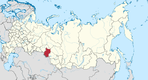
The Omsk Oblast ( Russian Омская область / Omskaja oblast ) is an oblast in Russia .
The oblast is located in the south of the West Siberian lowlands and borders in the west and north on the Tyumen Oblast , in the east on the Oblast Tomsk and Novosibirsk , and in the south and southwest on Kazakhstan . The most important river is the Irtysh .
history
After the area came under Russian sovereignty through Yermak at the end of the 16th century , Russian settlement began. Around 1900 resettlers of German origin (especially Russian Mennonites ) from the European part of Russia founded several settlements with up to 100% German-speaking population, whose colloquial language Plautdietsch , a Low German dialect with a “Russian touch”, is still spoken there today. In 1944 an epidemic of Omsk fever broke out in the northern districts of Omsk .
population
The last Russian censuses in 2002 and 2010 showed a population of 2,079,220 and 1,977,665 residents, respectively. The number of inhabitants thus fell by 101,555 people (−4.88%) in these eight years. In 2010, 1,413,226 people lived in cities. This corresponds to 71.46% of the population (in Russia 73%). By January 1, 2014, the population continued to decrease to 1,973,876 people. The distribution of the different ethnic groups was as follows:
| nationality | VZ 1989 | percent | VZ 2002 | percent | VZ 2010 | percent |
|---|---|---|---|---|---|---|
| Russians | 1,720,387 | 80.32 | 1,735,512 | 83.47 | 1,648,097 | 83.34 |
| Kazakhs | 74,991 | 3.50 | 81,618 | 3.93 | 78,303 | 3.96 |
| Ukrainians | 104,830 | 4.89 | 77,884 | 3.75 | 51,841 | 2.62 |
| German | 134.199 | 6.27 | 76,334 | 3.67 | 50,055 | 2.53 |
| Tatars | 49,784 | 2.32 | 47,796 | 2.30 | 41,870 | 2.12 |
| Armenians | 2.175 | 0.10 | 6,644 | 0.32 | 7,300 | 0.37 |
| Belarusians | 10,964 | 0.51 | 9,075 | 0.44 | 6,051 | 0.31 |
| Azerbaijanis | 2.023 | 0.09 | 4,260 | 0.20 | 4,230 | 0.21 |
| Tschuwaschen | 5,683 | 0.27 | 4.191 | 0.20 | 3,065 | 0.15 |
| Uzbeks | 1,250 | 0.06 | 1,244 | 0.06 | 2,810 | 0.14 |
| Jews | 5,428 | 0.25 | 2,393 | 0.12 | 1,652 | 0.08 |
| Residents | 2,141,909 | 100.00 | 2,079,220 | 100.00 | 1,977,665 | 100.00 |
Note: the proportions refer to the total number of inhabitants. Including the group of people who did not provide information on their ethnic affiliation (2002 3,356 and 2010 57,518 people)
The area's population is over 80% Russians. The Kazakhs, Ukrainians, Russian Germans and Tatars are the most important ethnic minorities in Omsk Oblast. Their number - like the number of Belarusians, Chuvashes and Jews - is falling sharply, however. The Kazakhs are an exception among the largest ethnic groups. Their number rose from 44,876 in 1959 to 81,618 in 2002 - and fell only slightly until 2010. Thousands of people have immigrated from the Transcaucasus and Central Asia since the end of the Soviet Union .
.jpg)
The Deutsche Nationalrajon Asowo, founded in 1992, is located southwest of Omsk . When it was founded, around 60% of the approximately 60,000 inhabitants were Russian-Germans. Most of them have since emigrated to the Federal Republic of Germany . They were replaced by immigrants from other parts of the former Soviet Union, some of them Russian-German, but mostly Russian as their mother tongue. Despite the strong emigration of Russian Germans to Germany in the 1990s, the Omsk Oblast still has the highest percentage of Germans in the total population of all federal subjects in Russia. Along with Azovo (19.68%), the highest proportions of Russian Germans have the Rajons Scherbakul (8.90%), Moskalenki (8.45%), Marjanowka (8.41%), Poltavka (7.61%), Issilkul ( 6.99%), Russkaya Polyana (6.87%), Lyubinsky (6.61%) and Odesskoye (6.35%). In absolute numbers, these are the city of Omsk (14,470), the Azovo national district (4,512) and the districts of Omsk (3,351), Issilkul (3,035) and Lyubinsky (2,496).
economy
The most important industries include oil refining, the armaments, food and wood industries. Fertile black earth soils ensure relatively productive agriculture.
Administrative divisions and cities
The Omsk Oblast is divided into 32 Rajons and an urban district , which forms the administrative center of the Oblast, the megacity of Omsk . There are a total of six cities and 21 urban-type settlements in the oblast . More than half of the population lives in the city of Omsk, the only major city in the oblast.

| Surname | Russian | Residents (October 14, 2010) |
|---|---|---|
| Omsk | Омск | 1,154,116 |
| Tare | Тара | 27,318 |
| Issilkul | Исилькуль | 24,482 |
| Kalachinsk | Калачинск | 23,556 |
Web links
Individual evidence
- ↑ Administrativno-territorialʹnoe delenie po subʺektam Rossijskoj Federacii na 1 janvarja 2010 goda (administrative-territorial division according to subjects of the Russian Federation as of January 1, 2010). ( Download from the website of the Federal Service for State Statistics of the Russian Federation)
- ↑ a b Itogi Vserossijskoj perepisi naselenija 2010 goda. Tom 1. Čislennostʹ i razmeščenie naselenija (Results of the All-Russian Census 2010. Volume 1. Number and distribution of the population). Tables 5 , pp. 12-209; 11 , pp. 312–979 (download from the website of the Federal Service for State Statistics of the Russian Federation)
- ^ Zoonoses: Infectious diseases that can be transmitted from animal to human, edited by Hartmut Krauss
Republics: Adygea | Altai | Bashkortostan | Buryatia | Khakassia | Dagestan | Ingushetia | Kabardino-Balkaria | Kalmykia | Karachay-Cherkessia | Karelia | Komi | Crimea 1 | Mari El | Mordovia | North Ossetia-Alania | Sakha (Yakutia) | Tatarstan | Chechnya | Chuvashia | Tuva | Udmurtia
Regions ( Krai ): Altai | Khabarovsk | Kamchatka | Krasnodar | Krasnoyarsk | Perm | Primorye | Stavropol | Transbaikalia
Areas ( Oblast ): Amur | Arkhangelsk | Astrakhan | Belgorod | Bryansk | Irkutsk | Ivanovo | Yaroslavl | Kaliningrad | Kaluga | Kemerovo | Kirov | Kostroma | Kurgan | Kursk | Leningrad | Lipetsk | Magadan | Moscow | Murmansk | Nizhny Novgorod | Novgorod | Novosibirsk | Omsk | Orenburg | Oryol | Penza | Pskov | Ryazan | Rostov | Sakhalin | Samara | Saratov | Smolensk | Sverdlovsk | Tambov | Tyumen | Tomsk | Chelyabinsk | Tula | Tver | Ulyanovsk | Vladimir | Volgograd | Vologda | Voronezh
Cities with subject status: Moscow | Saint Petersburg | Sevastopol 1
Autonomous Oblasts: Jewish Autonomous Oblast
Autonomous circles : Khanty and Mansi / Ugra | Yamal-Nenets | Nenets | Chukchi
1 Internationally Disputed Areas