
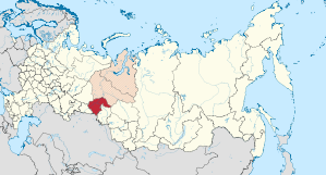
Tyumen Oblast
|
Subject of the Russian Federation
Tyumen Oblast
Тюменская область
|
||||||||||||||||||||||||||||||||||||
 .svg) |


Coordinates: 57 ° 39 ' N , 69 ° 0' E
The Tyumen Oblast ( Russian Тюменская область / Tjumenskaja oblast ) is an oblast in Russia . From an administrative point of view, the Khanty and Mansi / Yugra and Yamal-Nenets autonomous districts also belong to Tyumen Oblast, but they form independent federal subjects. The asteroid (2120) Tyumenia was named after the oblast.
geography
The oblast in the narrower sense is located in the south of the West Siberian lowlands and borders in the north on the Khanty and Mansi Autonomous District , in the east on the Tomsk and Omsk Oblast , in the southeast on Kazakhstan and in the west on the Kurgan Oblast and the Sverdlovsk Oblast . The most important rivers are the Irtysh and its tributaries Tobol and Ishim .
Without the autonomous districts of the Khanty and Mansi and the Yamal-Nenets, the oblast has an area of 159,870 km² and over 1.3 million inhabitants, with the autonomous districts just under 3.4 million inhabitants on 1,378,319 km².
history
The history of Russian settlement began at the end of the 16th century. The city of Tobolsk was even the capital of Siberia for a while. The Tyumen Oblast of the Russian SFSR was formed on August 14, 1944 from areas previously belonging to the Oblasts of Omsk and Kurgan .
population
In the last Russian censuses in 2002 and 2010, there were a population of 1,325,018 and 1,340,608 residents respectively. Thus, the population increased by 15,590 people (+1.18%) in these eight years. In 2010, 808,984 people lived in cities. This corresponds to 60.34% of the population (in Russia 73%). The distribution of the different ethnic groups was as follows:

| nationality | VZ 1989 | percent | VZ 2002 | percent | VZ 2010 | percent |
|---|---|---|---|---|---|---|
| Russians | 1,105,149 | 83.70 | 1,091,571 | 82.38 | 1,066 066 | 79.52 |
| Tatars | 103.303 | 7.82 | 106,954 | 8.07 | 102,587 | 7.65 |
| Ukrainians | 26,864 | 2.03 | 22,054 | 1.66 | 16,988 | 1.27 |
| Kazakhs | 11,170 | 0.85 | 12,977 | 0.98 | 13,232 | 0.99 |
| German | 17,452 | 1.32 | 16,320 | 1.23 | 12,048 | 0.90 |
| Tschuwaschen | 13,579 | 1.03 | 11,214 | 0.85 | 8,623 | 0.64 |
| Azerbaijanis | 3.191 | 0.24 | 8,918 | 0.67 | 8,282 | 0.62 |
| Armenians | 1,412 | 0.11 | 6,777 | 0.51 | 7,594 | 0.57 |
| Belarusians | 8,673 | 0.66 | 6,489 | 0.49 | 4,465 | 0.33 |
| Tajiks | 425 | 0.03 | 1,734 | 0.13 | 3053 | 0.23 |
| Uzbeks | 1,054 | 0.08 | 1,569 | 0.12 | 2,998 | 0.22 |
| Bashkirs | 3,078 | 0.23 | 2,836 | 0.21 | 2,680 | 0.20 |
| Residents | 1,320,417 | 100.00 | 1,325,018 | 100.00 | 1,340,608 | 100.00 |
Note: the proportions refer to the total number of inhabitants excluding the population of the Khanty-Mansi and Yamal-Nenets Autonomous Counties. Including the group of people who did not provide any information about their ethnic affiliation (2002 10,699 and 2010 68,148 people)
About 80% of the population of the area is Russian. The Tatars are the most important ethnic minority in Tyumen Oblast. The number of Ukrainians, Russian Germans (1959: 21,158 people), Chuvashes, Belarusians and Bashkirs is falling sharply. By contrast, thousands of people have immigrated from the North Caucasus, Transcaucasus and Central Asia since the end of the Soviet Union. In addition to the nationalities listed above, there are also many Kyrgyz people (1989: 560; 2010: 1,825 people) and Ingush (1989: 976; 2010: 1,673).
The peoples of the autonomous counties are only sparsely represented in the actual Tyumen Oblast. The censuses resulted in: Chanten (1989: 1,232; 2010: 720), Mansen (1989: 490; 2010: 471) and Nenzen (1989: 558; 2010: 411).
economy
The most important branches of industry are the petrochemical industry, wood processing and mechanical engineering. Due to the wealth of oil and natural gas, the area is one of the richest in Russia. If the Khanty and Mansi / Yugra and Yamalo-Nenets are included, Tyumen Oblast has the highest regional GDP per capita of any area in Russia. Broken down by federal subjects, the actual Tyumen Oblast is also in the forefront according to this parameter, but is exceeded many times over by the two autonomous districts, in particular that of the Khanty and Mansi.
partnership
The state of Lower Saxony has been a partner region of the Tyumen Oblast since 1992 .
Administrative division and largest localities
The Tyumen Oblast is divided into 22 Rajons and five urban districts . The city districts are made up of the five cities in the oblast; besides the administrative center of Tyumen, Tobolsk and Ishim are the most important.

![]() Map with all coordinates: OSM | WikiMap
Map with all coordinates: OSM | WikiMap
| Surname | Russian | City district / Rajon | Residents (October 14, 2010) |
coat of arms | location |
|---|---|---|---|---|---|
| Ishim | Ишим | Urban district | 65,243 | 56 ° 7 ' N , 69 ° 30' E | |
| Yalutorovsk | Ялуторовск | Urban district | 36,493 | 56 ° 39 ' N , 66 ° 18' E | |
| Zavodoukovsk | Заводоуковск | Urban district | 25,647 | 56 ° 30 ' N , 66 ° 33' E | |
| Tyumen | Тюмень | Urban district | 581.907 | 57 ° 9 ' N , 65 ° 32' E | |
| Tobolsk | Тобольск | Urban district | 99,694 | 58 ° 12 ' N , 68 ° 15' E |
The previous five urban-type settlements were converted into rural settlements in 2009. Four of them had over 10,000 inhabitants at this point in time (as of January 1, 2009): Borowski (16,446), Winsili (12,739) and Bogandinski (10,374) in the Tyumen agglomeration ; also Golyschmanowo (14,582).
Web links
- Official website of Tyumen Oblast (Russian)
Individual evidence
- ↑ Administrativno-territorialʹnoe delenie po subʺektam Rossijskoj Federacii na 1 janvarja 2010 goda (administrative-territorial division according to subjects of the Russian Federation as of January 1, 2010). ( Download from the website of the Federal Service for State Statistics of the Russian Federation)
- ↑ a b Itogi Vserossijskoj perepisi naselenija 2010 goda. Tom 1. Čislennostʹ i razmeščenie naselenija (Results of the All-Russian Census 2010. Volume 1. Number and distribution of the population). Tables 5 , pp. 12-209; 11 , pp. 312–979 (download from the website of the Federal Service for State Statistics of the Russian Federation)
- ↑ Ukas of the Presidium of the Supreme Soviet of August 14, 1944 (Russian)
- ^ [1] Population of Tyumen Oblast 1989
- ^ [2] Population of the Chanten and Mansen Autonomous District 1989
- ^ [3] Population of the Yamalo-Nenets Autonomous Okrug, 1989
- ↑ Annual economic data from the Federal Service for State Statistics of Russia (Russian, partly English)
- ^ Joint declaration of May 21, 1992 , accessed on September 1, 2015
- ↑ Law of the Tyumen Oblast on changes to the administrative structure of February 12, 2009 (Russian; PDF ( page no longer available , search in web archives ) Info: The link was automatically marked as defective. Please check the link according to the instructions and then remove this notice. , Pp. 42–77)
Republics: Adygea | Altai | Bashkortostan | Buryatia | Khakassia | Dagestan | Ingushetia | Kabardino-Balkaria | Kalmykia | Karachay-Cherkessia | Karelia | Komi | Crimea 1 | Mari El | Mordovia | North Ossetia-Alania | Sakha (Yakutia) | Tatarstan | Chechnya | Chuvashia | Tuva | Udmurtia
Regions ( Krai ): Altai | Khabarovsk | Kamchatka | Krasnodar | Krasnoyarsk | Perm | Primorye | Stavropol | Transbaikalia
Areas ( Oblast ): Amur | Arkhangelsk | Astrakhan | Belgorod | Bryansk | Irkutsk | Ivanovo | Yaroslavl | Kaliningrad | Kaluga | Kemerovo | Kirov | Kostroma | Kurgan | Kursk | Leningrad | Lipetsk | Magadan | Moscow | Murmansk | Nizhny Novgorod | Novgorod | Novosibirsk | Omsk | Orenburg | Oryol | Penza | Pskov | Ryazan | Rostov | Sakhalin | Samara | Saratov | Smolensk | Sverdlovsk | Tambov | Tyumen | Tomsk | Chelyabinsk | Tula | Tver | Ulyanovsk | Vladimir | Volgograd | Vologda | Voronezh
Cities with subject status: Moscow | Saint Petersburg | Sevastopol 1
Autonomous Oblasts: Jewish Autonomous Oblast
Autonomous circles : Khanty and Mansi / Ugra | Yamal-Nenets | Nenets | Chukchi
1 Internationally Disputed Areas