Primorye region
|
Subject of the Russian Federation
Primorye
Приморский край
|
||||||||||||||||||||||||||||||||||||
Coordinates: 45 ° 30 ' N , 135 ° 0' E

The Primorye ( Russian Приморский край / Primorski krai ) is an administrative region ( Krai ) in Russia . "Primorye" means "on" or "located in front of the sea" and refers to the location of the region.
geography
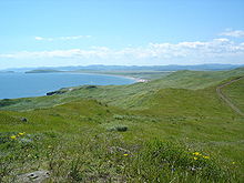
The region is located in the extreme southeast of Russia on the Sea of Japan . It borders China and the Khabarovsk region in the north, and there is also a short border between North Korea and Russia on the Pacific . The surface of the region is mountainous, it is largely occupied by the Sichote-Alin Mountains, more than 80% is forested. There are numerous short rivers, the longest being the Ussuri , which also forms the border with China. On both sides of the border lies the approximately 4,000 km² Chankasee .
population
As in many other Russian regions, rising death rates and falling birth rates have led to a decline in the population. The population is distributed very unevenly, a third of the region is uninhabited. The population consists largely of Russians , in the cities there are also Russian Germans , Tatars and Koreans . The indigenous population (including Nanaians , Udehe and Oroken ) makes up less than 1%.
history
Pre-Russian time
Paleo-Siberian peoples have inhabited the area for at least 30,000 years. In historical times, the area belonged to Goguryeo , a Korean state. In 698 the Korean-Manchurian state of Balhae (Bohai) arose in the area, and existed until 936. The Jurchen Empire existed in the 11th and 12th centuries . At this time trade relations with China , Japan and Korea were established . Subsequently, the region fell into oblivion.
Russia
The first Russians arrived in the 17th century, but to a greater extent only after 1860, when the Russian-Chinese border was established along the Amur and Ussuri Rivers in the Beijing Convention . In the same year, Vladivostok (in German "Rule the East") was founded. Around 250,000 settlers had reached the region by 1917, with the Trans-Siberian Railway facilitating their immigration.
Soviet Union
During the Russian Civil War , the region was the last part of Russia to be captured by the Bolsheviks:
- November 29, 1917 The Soviets take power in Vladivostok
- April 1918 Landing of the Japanese in Vladivostok, who remove Soviet rule
- August 1918 Landing of Entente troops in Vladivostok, supporting Kolchak
- 1920 Establishment of the Pro-Soviet Far Eastern Republic , which also lays claim to Vladivostok
- April 1920 Entente troops withdrew after the destruction of Kolchak
- 1921 Founding of the coastal republic by the Japanese occupiers
- October 1922 withdrawal of the Japanese and dissolution of the coastal republic
- November 1922 The Far Eastern Republic is annexed to the Soviet Union
- December 1922 Invasion of the Red Army in Vladivostok
The Primorye region was created in 1938 by dividing the Far Eastern region into Primorye and the Khabarovsk Krai .
Because of its strategic importance as the home port of the Soviet Pacific Fleet, the city of Vladivostok was " closed " after the Second World War , and foreigners were only allowed to move here again after the end of the Soviet Union.
Transport and economy
The Trans-Siberian Railway ends in Vladivostok after 9288 kilometers from Moscow . There are also connections to China ( Harbin ). Coal mining, the food industry, especially the catching and processing of fish, mechanical engineering (including aircraft construction and the armaments industry) and the wood industry are of economic importance.
Administrative divisions and cities
The region is divided into 22 Rajons and 12 urban districts . Two of the city districts ( Bolshoi Kamen and Fokino ) are also “ closed cities ” (SATO).
Other major cities in the region in addition to its administrative center Vladivostok are Ussuriysk , Nakhodka and Artyom . There are a total of 12 cities and 28 urban-type settlements in the region .
| Surname | Russian | Resident October 14, 2010 |
|---|---|---|
| Vladivostok | Владивосток | 592.034 |
| Nachodka | Находка | 159,719 |
| Ussuriysk | Уссурийск | 158.004 |
| Artyom | Артём | 102.603 |
| Arsenyev | Арсеньев | 56,750 |
Web links
Individual evidence
- ↑ Administrativno-territorialʹnoe delenie po subʺektam Rossijskoj Federacii na 1 janvarja 2010 goda (administrative-territorial division according to subjects of the Russian Federation as of January 1, 2010). ( Download from the website of the Federal Service for State Statistics of the Russian Federation)
- ↑ a b Itogi Vserossijskoj perepisi naselenija 2010 goda. Tom 1. Čislennostʹ i razmeščenie naselenija (Results of the All-Russian Census 2010. Volume 1. Number and distribution of the population). Tables 5 , pp. 12-209; 11 , pp. 312–979 (download from the website of the Federal Service for State Statistics of the Russian Federation)
- ^ Atlas zur Geschichte (GDR) 2, Haack, 1982 Gotha, p. 3


