
Far East (Federal District)
| Far East Federal District | |
|---|---|
  |
|
| Surface: | 6,952,555 km² |
| Administrative headquarters : | Vladivostok |
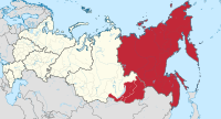
The Far East Federal District ( Russian Дальневосточный федеральный округ , Dalnewostochny federalny okrug ) is an administrative unit ( federal district ) of the Russian Federation on the Pacific (see Federal structure of Russia ). The administrative seat is in Vladivostok .
geography


The "Far East" ( Дальний восток , Dalni wostok) is the name given to the Pacific region of Russia , which includes the Sakha (former Yakutia) regions , the Jewish Autonomous Oblast and the Kamchatka Peninsula . In the east the federal district borders on the Pacific with its marginal seas Bering Sea and Okhotsk Sea , in the north on the Arctic Ocean with the marginal seas East Siberian Sea and the Laptev Sea , in the south on the People's Republic of China , Japan and North Korea and in the west on the federal district Siberia .
The largest archipelagos in the Arctic Ocean are the New Siberian Islands and Wrangel Island . In the Pacific, the Kuril Islands, the Commander Islands and Sakhalin form the largest Russian islands. The capital of the district is Khabarovsk with over 600,000 inhabitants. The Far East Federal District, with an area of almost seven million km², accounts for around 40% of the total area of the country and is the largest of the eight federal districts in Russia.
The Far East is more mountainous than the rest of Asiatic Russia. The Pobeda in the Tscherski Mountains reaches 3000 meters. The Stanowoy Mountains reach heights of 2255 meters. The Sichote-Alin north of Vladivostok , home to several hundred Siberian tigers , reaches heights of over 1700 meters. However, the giants of the region are the volcanoes of Kamchatka, for example the Korjakskaja Sopka . Of these, around 20 are still active. The Klyuchevskaya Sopka reaches an altitude of 4688 meters. The Lena , which drains a large part of Yakutia, is the third longest river in Russia, followed by the Amur , the fourth longest river, which also forms the border with China.
history

In the course of the Russian conquest of Siberia from the end of the 16th century, Russian colonizers gradually approached the Pacific along the Siberian rivers. The Russians reached the Lena in 1630 and founded Yakutsk in 1632 and Okhotsk in 1649 on the Pacific. Towards the end of the 17th century , the Russian Empire controlled an approximately 300 kilometer wide coastal strip on the Pacific. In the 18th century Russia annexed Kamchatka and the Anadyr Peninsula in the northeast of the Asian continent. While the Russian expansion in the north was almost unmolested and without resistance from the few indigenous people, it encountered greater difficulties on the southern borders of the Russian Far East. In the 17th century, the Russians and the Chinese came into each other's way for the first time in what is now the Amur Oblast and Primorye Region . The Chinese Qing dynasty expanded northwards and for the time being retained the upper hand and blocked the Russians' further path to the Pacific. In 1689 the Treaty of Nerchinsk was signed between the two powers. This ended the border conflicts and determined the border along the Stanowoy Mountains .
With the decline of Chinese power in the 19th century, Russia again had the opportunity to expand further. In 1858 the border was moved further south along the Amur and in 1859 the area to the Pacific was ceded by China. Vladivostok was founded in 1860. Sakhalin and the Kuril Islands were under joint Russian-Japanese administration from 1854 to 1875. Both powers agreed in 1875 on a division of their common property. While the Kuril Islands went to Japan, Russia received Sakhalin. From 1860 onwards, the emerging Japanese Empire was the main challenge for Russian expansion in the Far East. The Russian engagement of Emperor Nicholas II in Manchuria , which clashed with the Japanese Empire regarding hegemony over Korea , triggered the Russo-Japanese War from February 1904 to autumn 1905. The Russian Empire lost the war and had to cede some areas, such as the southern half of the Sakhalin Island.
The Far Eastern Republic was founded after the Communist October Revolution and the Bolshevik seizure of power across the country on April 6, 1920, to act as a buffer state in a direct war between Soviet Russia and Japan , since 70,000 Japanese along with 10,000 US soldiers were anti-communist as part of the Siberian intervention Troops of the "white" Russians supported. Japan itself occupied Vladivostok and parts of the Pacific coast, and since 1918 also adjacent Chinese areas, and founded the coastal republic . It was not until 1922 that these republics were rejoined to the Soviet Union .
During Operation August Storm , the Red Army captured the southern part of Sakhalin and the Kuril Islands in August and September 1945 . To this day, Japan reserves the right to own the four southernmost islands. China and the former Soviet Union faced each other militarily in the Far East in 1969, when military skirmishes broke out over the status of small islands in Ussuri (see incident on Ussuri ). It was not until 2004 that Vladimir Putin and his Chinese counterpart Hu Jintao finally settled the dispute, with Russia ceding two of the last three islands with unclear status to China and dividing the third.
The Far East was of great strategic importance during the Cold War . The main bases of Russia's Pacific Fleet , which, among other things, served as a nuclear deterrent against the USA , are still today in Vladivostok and in Petropavlovsk-Kamchatsky on the Kamchatka Peninsula. From here, the nuclear-powered submarines armed with nuclear weapons could reach the west coast of North America within a few days.
In the course of the transformation period after 1991, the Far East lost over a million inhabitants, while entire industrial sectors were lost. The Russian government, based in Moscow , 7,000 kilometers away , first expressed concern in 2006 about the remoteness and backwardness of the Russian Far East. President Vladimir Putin described them as a threat to national security. In May 2012, President Putin signed a decree expanding the central government to include a Khabarovsk-based Ministry for Far East Development. On March 21, 2013, the central government passed a program for the development of the Far East. It looks at the level of 321 billion by 2025 spending dollars before. The goals are to transform the Far East into a competitive region with a diverse economy and to improve the social and demographic situation on the territory of the region. These measures are seen in Russia as the beginning of a recovery process.
population

The Far East has traditionally been one of the least populated parts of Russia. The population of the Far East peaked in 1990 at just over eight million. This was the result of massive (and not always voluntary) resettlement measures that had been carried out since the mid-19th century. The so-called " small peoples " belong primarily to the indigenous population . The Yakuts are an exception , a very large ethnic group who predominantly (97 percent) live in the Sakha Republic (Yakutia) and make up half of the total population there. The republic is the only federal subject in the Far East federal district in which ethnic Russians are not the dominant ethnic group. Many traditional peoples (e.g. Korjak , Niwchen ) are descendants of fishermen and hunters.
Regardless of the geographic location of the region, its inhabitants culturally tend towards Europe rather than Asia . A large part of today's population (95%) is made up of Russian or Ukrainian resettlers and their descendants. Most of the resettlers came to the Far East during the Soviet era.
The economic and political changes that took place in the state and society in the early 1990s had negative consequences for the demographic situation in the region. The northern regions in particular experienced a veritable exodus after the collapse of the Soviet Union . While agriculture, transport and trade in the south were able to at least partially absorb the industrial crisis, the people in the north often only had to leave. The sparsely populated Chukchi Autonomous Okrug lost two thirds of its inhabitants by 2004, and the Magadan region lost more than half; entire settlements were lost. Those who moved were mostly ethnic Russians or Ukrainians who had only come to the east during the Soviet era.
The population of the Far East Federal District as of January 1, 2014 was 6.227 million or 4.34% of the total population of Russia. The district has the lowest population density of the federal districts. 76 percent of the population live in urban centers.
The largest cities in the federal district are (as of 2014):
- Khabarovsk : 607,216
- Vladivostok : 603,244
- Ulan-Ude : 404.426
- Chita : 324,444
- Yakutsk : 299.169
- Komsomolsk-on-Amur : 253.030
- Blagoveshchensk : 224.192
- Yuzhno-Sakhalinsk : 192,734
- Petropavlovsk-Kamchatsky : 182,711
- Ussuriysk : 166819
- Nakhodka : 156442
- Artyom : 102,405
- Magadan : 94,344
- Birobidzhan : 74,777
Climate, flora and fauna

The climate in the Far East varies from continental to temperate . Here is the cold pole of the northern hemisphere (in the settlement of Ojmjakon ). The lowest temperature ever recorded was recorded in the territory of the Far East at 71 ° C below freezing. The cold winters in the Far East are dry and sunny. Due to the dryness of the air, even severe frosts can be endured more easily. In the Sakha Republic in particular, rivers remain frozen during the seven-month winter. The coast of the Arctic Ocean also freezes over during this time. The Far East is 46 percent forested. Large parts of it in the north are covered with boreal coniferous forest. The far north belongs to the climatic zone of the tundra with low shrubs, lichen and moss. The ground there is frozen over long stretches ( permafrost ). This makes the settlement and construction very complex. One square meter of living space on the Chukchi Peninsula is about ten times more expensive to build than in Vladivostok, which is in the temperate climate zone. In the northern part of the Far East, arable farming is only possible in very few protected areas; otherwise, agricultural use is generally limited to timber .
There are 2.7 million hectares of arable land on the county’s territory. This is two percent of the total area of the federal district. The farmland is concentrated around Lake Chanka and the Amur. The Primorye region - the area directly on the Pacific coast - is located at similar latitudes to Sochi on the Russian Black Sea coast , and the sun shines here 180–200 days a year. In the south of the Primorsky Krai, the mountains are covered with special forests, a mixture of conifers and broad-leaved deciduous trees, the so-called Ussuri-Taiga.
structure
.svg) |
||||||
| # | flag | Federation subject | Area in km² |
Population 2010 |
Population 2015 |
Capital / administrative center |
|---|---|---|---|---|---|---|
| 1 |
|
Amur Oblast | 363,700 | 830.103 | 809.873 | Blagoveshchensk |
| 2 |
|
Republic of Buryatia | 351,300 | 972,000 | 978,000 | Ulan-Ude |
| 3 |
|
Jewish Autonomous Oblast | 36,000 | 176,558 | 168,368 | Birobidzhan |
| 4th |
|
Transbaikalia region | 431,900 | 1,107,000 | 1,087,000 | Chita |
| 5 |
|
Kamchatka Region | 464,300 | 322.079 | 317.269 | Petropavlovsk-Kamchatsky |
| 6th |
|
Magadan Oblast | 462,400 | 156.996 | 148.071 | Magadan |
| 7th |
|
Primorye region | 165,200 | 1,956,497 | 1,933,308 | Vladivostok |
| 8th |
|
Republic of Sakha | 3.103.200 | 958.528 | 956.896 | Yakutsk |
| 9 |
|
Sakhalin Oblast | 87,100 | 497.973 | 488.391 | Yuzhno-Sakhalinsk |
| 10 |
|
Khabarovsk region | 788,600 | 1,343,869 | 1,338,305 | Khabarovsk |
| 11 |
|
Chukchi Autonomous Okrug | 737,500 | 50,526 | 50,540 | Anadyr |
| (Total) | 6.991.200 | (6,293,129) | (6,211,021) | |||
In November 2018, the Republic of Buryatia and the Transbaikalia Region moved from the Siberian Federal District to the Far East Federal District . Population data are not yet included in the totals above.
economy
The federal district is rich in raw materials. Gold and diamonds are mined in the Sakha Republic, and oil and natural gas are mined on Sakhalin . The total energy yield from Sakhalin is estimated at a total of 700 million tons of oil and 2,500 billion cubic meters of gas. The Primorye region is rich in tin and graphite . In the Jewish Autonomous Region to find deposits of iron and manganese ore .
Russia's Far East has lost around 90 percent of its heavy industry since 1990 , including the strong armaments and paper industries and the fish processing sector. In addition, the area generates only 5.6 percent of the national GDP. The remaining economic activities concentrate very much on the extraction of raw materials.
The world's largest integrated oil and gas project, Sakhalin 2 , is being implemented on the Sakhalin Peninsula . The development of the project was entrusted to the Sakhalin Energy Investment Company Ltd. ( Sakhalin Energy ), a consortium founded in 2000 under the leadership of Shell with the participation of Japanese companies Mitsui and Mitsubishi . For many years this was the largest foreign investment in Russia, and in 2007 Gazprom took over the majority stake.
The most important industrial sectors that are still intact are mining , gold mining, the electrical industry , fishing and forestry as well as non-ferrous metallurgy and shipbuilding . Forestry and wood processing in the Primorye and Khabarovsk regions and in the Amur region have a large share of total Russian wood exports. The Federal District is also heavily involved in the production of sawn timber, fibreboard and furniture.
The agriculture and fishing has traditionally been strong; this also includes reindeer and fur farming . With the development of mineral resources and processing in the region, the economic importance of the Federal District of the Far East will increase significantly. The Federal District is already working closely with China , Japan, South and North Korea.
The most important trading partners in the Far East are China and Japan, followed by Taiwan and Vietnam . Many everyday goods have to be imported by ship or plane, which is a laborious process. The proximity to China now allows a cheaper supply, especially with food. Japan mainly supplies used cars and other technical goods.
traffic

The two largest international airports are Vladivostok Airport and Khabarovsk Airport . In addition to domestic Russian destinations, there are also direct international connections to Tokyo , Seoul and Beijing, among others .
The Trans-Siberian Railway runs through the southern part of the region with branches to the border with China and the Pacific coast.
In accordance with its economic importance, the expansion of the infrastructure in the Far East Federal District is one of the most important projects in Russia. The priority projects of the railway sector from 2010 to 2015 include the construction of the railway connection between the Khabarovsk region and Sakhalin across the Tatar Sound , the continuation of the construction of the connection between the Baikal-Amur Mainline (BAM) and Yakutsk and the construction of the North Siberian Railway from Nadym to Yakutsk, which is to become a railway junction in northern Siberia.
The port of Vladivostok, which is navigable all year round and is kept ice-free, is located directly on the Sea of Japan . About 80 kilometers east of it is Nakhodka and directly adjacent Vostochny , the two largest trading ports in the Russian Far East. Container transport by ship from here to Scandinavia takes 40 days, while transport by rail for the same route takes around 12 days.
Individual evidence
- ↑ Mikhail S. Blinnikov: A Geography of Russia and Its Neighbors, 2011, p. 401
- ↑ John C. Dewdney: A Geography of the Soviet Union: Pergamon Oxford Geographies, 3rd Edition, pp. 41f
- ↑ http://www.berlin-institut.org/fileadmin/user_upload/Russland/Russland_d_online.pdf Stephan Sievert, Sergei Sacharow, Reiner Klingholz: Die shrinking world power, Berlin Institute for Population and Development, 2011, accessed on June 13 2015
- ↑ http://www.poezdka.de/113/Russland/ferner-osten.html accessed on June 12, 2015
- ↑ Mikhail S. Blinnikov: A Geography of Russia and Its Neighbors, 2011, p. 403
- ↑ Оценка численности постоянного населения на 1 января 2015 года и в среднем за 2014 год (опубликоварда) 17. Проверено 18 марта 2015. Архивировано из первоисточника 18 марта 2015.
- ↑ Archive link ( Memento of the original from June 14, 2015 in the Internet Archive ) Info: The archive link was inserted automatically and has not yet been checked. Please check the original and archive link according to the instructions and then remove this notice. Retrieved June 12, 2015
literature
- John J. Stephan: The Russian Far East: A History . Stanford University Press, Stanford 1994, ISBN 0-8047-2701-5