Tatar Sound
| Tatar Sound | ||
|---|---|---|
| Tatar Sound | ||
| Connects waters | Sea of Okhotsk | |
| with water | Japanese sea | |
| Separates land mass | Sakhalin | |
| of land mass | Russian mainland | |
| Data | ||
| Geographical location | 52 ° 11 ′ 0 ″ N , 141 ° 37 ′ 0 ″ E | |
|
|
||
| Smallest width | 7.3 km | |
| Location of the Tatar Sound | ||
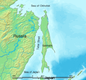
The Tatar Strait ( Russian Татарский пролив / Tatarski proliw ; also Tartarian Sund , Tartar road , Tartar road ) is a strait between the northern part of the island Sachalin and the Asian continent. It connects the Sea of Japan with the Sea of Okhotsk . The Tatar Strait is not for the people of the Tartars , but according to the historical landscape designation Tartary named.
The narrowest point is 7.3 km wide. This place is called Nevelskoi Street (Russian пролив Невельского ) after the Russian admiral Gennady Nevelskoi .
In 1849 Nevelskoi was the first Russian seafarer to reach the mouth of the Amur , thereby proving its navigability and the existence of the Tatar Sound, which connects the Okhotsk with the Sea of Japan . The mapping of Sakhalin carried out 40 years earlier by the Japanese navigator Mamiya Rinzō was not known in Russia and Europe .
Tunneling under the Tatar Sound
In the early 1950s, construction began on a tunnel under Nevelskoi Street, through which a railway line was to lead to Sakhalin Island . However, the construction work was canceled after the death of Stalin .
On the part of the Russian leadership, a general interest in the realization of the project has been shown in recent years, without, however, determining the time frame.
Individual evidence
- ↑ The Russian President wants to connect Sakhalin with the mainland. primamedia.ru, November 19, 2008 (Russian)


