
Anadyr (city)
| city
Anadyr
Анадырь
|
||||||||||||||||||||||||||||||||||||||||||
|
||||||||||||||||||||||||||||||||||||||||||
|
||||||||||||||||||||||||||||||||||||||||||
| List of cities in Russia | ||||||||||||||||||||||||||||||||||||||||||
.png)
.png)


Anadyr ( Russian Ана́дырь , Chukchi Кагыргын ) is the capital of the Chukchi Autonomous Okrug in Russia with 13,045 inhabitants (as of October 14, 2010).
The port city is located on the coast of the Bering Sea at the mouth of Anadyr in the Bay of Anadyr . Thus it has a connection to the Bering Strait .
| Anadyr | ||||||||||||||||||||||||||||||||||||||||||||||||
|---|---|---|---|---|---|---|---|---|---|---|---|---|---|---|---|---|---|---|---|---|---|---|---|---|---|---|---|---|---|---|---|---|---|---|---|---|---|---|---|---|---|---|---|---|---|---|---|---|
| Climate diagram | ||||||||||||||||||||||||||||||||||||||||||||||||
| ||||||||||||||||||||||||||||||||||||||||||||||||
geography
The city of Anadyr is located at the tip of a large cape on the southern edge of the Anadyr Estuary in the permafrost zone. The urban area is located on a gentle slope that rises from the sea. On the other side of the Anadyr River are mountains whose peaks are covered with snow even in summer. To the west, beyond the city, are large areas of flat tundra.
The distance from Anadyr to Moscow is 6192 km.
Anadyr is at a similar latitude as Fairbanks, Alaska, and Oulu, Finland.
history
The city was founded on August 3, 1889 by the Russian military doctor and polar explorer Lev Franzewitsch Grinewezkij as Novo-Mariinsk (Ново-Мариинск) at the mouth of the small river Kasachka (Каза́чка) in the Anadyr River, which - like the West Siberian city Mariinsk - after whom Tsarina Marija Alexandrovna was named.
In the following years the settlement developed only slowly; especially public and private trade warehouses were expanded.
In 1914 a long-wave radio station was completed in Anadyr - one of the most powerful in Russia at the time. He made communication possible with Petropavlovsk-Kamchatsky, Okhotsk and Nom in Alaska.
In 1923 the settlement was named Anadyr after the river, named like the fort built further upstream by Semyon Deschnjow in the 17th century . After the establishment of the Autonomous Okrug (initially as the "National District") in 1930, Anadyr became its administrative center in 1932.
The construction of a large seaport in the late 1950s gave the settlement a great boost. In 1963 a dam was built on the Kasachka River, which made it possible to build a water pipe to Anadyr.
In 1984 the first regular non-stop flight of IL-62 aircraft on the Moscow - Anadyr route was carried out.
Population development
| year | Residents |
|---|---|
| 1939 | 3,344 |
| 1959 | 5,859 |
| 1970 | 7,703 |
| 1979 | 12,241 |
| 1989 | 17.094 |
| 2002 | 11,038 |
| 2010 | 13,045 |
| 2018 | 15,604 |
Note: census data
economy
The fishing port of Anadyr is located on the inside of the bay of the same name ( Anadyrgolf ), facing the freshwater basin. After the steady downward trend of the 1990s, a few new facilities developed after the turn of the millennium, including a farm for laying hens , whose production is around 800,000 eggs per year, and the natural gas field on Zapadnoje ozero (West Lake), opened in 2001 , with the Anadyr connected by a pipeline opened in 2002 . In the same year the new building of the regional parliament was completed, the existing "Hotel Tschukotka" was renovated and another one was commissioned.
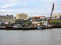
View of the city from the port

Infrastructure
Anadyr is an important seaport on the Bering Sea. The navigation period lasts four months (from July 1st to November 1st). The passenger ship "Captain Sotnikov" sails from Anadyr to the village of Lavrentija during this time.
The Ugolny airport of Anadyr served cities and towns in the Russian Far East, for with connections. B. to Khabarovsk , Vladivostok and Moscow. Bering Air offers charter flights to Nome , Alaska in the United States. The airport is on the other side of the Anadyr Gulf, and from January to May transportation from the airport to Anadyr is on an ice road. In the summer there is a ferry that takes passengers across the Anadyr River to the airport, but in the spring and autumn, when the river ice melts and the river is full of floating ice floes, the only means of transport to the airport is by helicopter.
So far there are no paved roads to more distant places. In 2012, the construction of a trunk road from Omsuktschan to Anadyr began, which will provide a year-round transport link between Anadyr and the road network of the Russian Far East.
Anadyr was one of three Russian landing points for the Russian Optical Trans-Arctic Cable System (ROTACS). This was an optical submarine cable planned in 2012 to connect the United Kingdom , Russia and Japan . The project has not been pursued any further since 2017.
Individual evidence
- ↑ a b Čislennostʹ naselenija gorodskich naselennych dotov, selʹskich naselennych dotov po Čukotskomu avtonomnomu okrugu. (Population of urban settlements, rural settlements in the Chukchi Autonomous Okrug.) Download from the website of the Chukchi Autonomous Okrug of the Federal Service of State Statistics of the Russian Federation
- ^ Patty A. Gray, Patricia Anne Gray, Patty a Gray: The Predicament of Chukotka's Indigenous Movement: Post-Soviet Activism in the Russian Far North . Cambridge University Press, 2005, ISBN 978-0-521-82346-3 , pp. 122 (English, google.de [accessed on February 20, 2020]).
- ↑ a b город Анадырь. April 23, 2016, accessed February 20, 2020 (Russian).
Web links
- Official website of the city administration
- City information portal (Russian)
- Entry at mojgorod.ru (Russian)
- Basemap 1: 2000 ( Memento from January 12, 2012 in the Internet Archive )
Rajons : Anadyrski | Bilibinski | Iultinski | Prowidenski | Tschaunski | Chukotsky
| Cities | |||||||
| Urban-type settlements |
Beringowski SG | Egwekinot S | Mys Schmidta | Providenia S | Ugolnye Kopi SG |
||||||
| More parish seats |
|
||||||
|
Other inhabited places in urban districts |