
Markowo (Chukotka)
| Village
Markowo
Марково
|
||||||||||||||||||||||||||||
|
||||||||||||||||||||||||||||
|
||||||||||||||||||||||||||||


Markowo ( Russian Ма́рково ) is a village (selo) in the Chukchi Autonomous Okrug ( Russia ) with 809 inhabitants (as of October 14, 2010).
geography
The place is in the central part of the Anadyr lowlands on the right bank of the Anadyr .
Markowo belongs to the Anadyrski district and is located just 350 km west of the district and district administrative center of Anadyr as the crow flies . It is the only village in the rural municipality of the same name (selskoje posselenije).

Church in Markowo (1901)
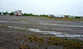
Markovo Airport


history
Markovo is located in the part of the region which, due to its relatively favorable climatic conditions, was the first to be colonized by the Russians on their expansion to the east, albeit on a modest scale. In the above only by nomadic living Chukchi , Yukagirs and Evens inhabited area already in 1649 from was Cossack Semyon Dezhnev and a 1650 butted him department Mikhail Staduchin about 20 km east (downstream) of today's region on the opposite bank of Anadyr of Anadyrski Ostrog built , later also called Anadyrsk .
The fortification was abandoned in 1764, but the now settled Russian population, partly mixed with the indigenous population of the Chuwans (also Chuwances ), remained in the area and founded the village of Markowo around 1840. This was the most important settlement of Chukotka until the 20th century, until it was replaced by settlements on the coast, especially today's city of Anadyr, in the 1930s.
From 1930 to 1960 Markowo was the administrative seat of the Markowski rajon named after him. During the Second World War , an airfield was built near the village on the route through which aircraft from the United States were transferred to the Soviet Union under the lend lease agreement . From the 1960s to 1998, Markowo had urban-type settlement status .
Population development
| year | Residents |
|---|---|
| 1897 | 311 |
| 1939 | 371 |
| 1959 | 1354 |
| 1970 | 1712 |
| 1979 | 1992 |
| 1989 | 2130 |
| 2002 | 922 |
| 2010 | 809 |
Note: census data
traffic
Markowo is not connected to the fixed road network, but can be reached via unpaved slopes in winter. A road from Anadyr and on to Omolon on the western border of the Autonomous Okrug is planned. From this point on, the Anadyr is considered navigable and there is a ship connection during the ice-free period.
There is an airport near Markowo ( ICAO code UHMO ), which connects to Anadyr.
Personalities
- Tatjana Jurjewna Achirgina (* 1944), journalist and poet
Individual evidence
- ↑ a b Čislennostʹ naselenija gorodskich naselennych dotov, selʹskich naselennych dotov po Čukotskomu avtonomnomu okrugu. (Population of urban settlements, rural settlements in the Chukchi Autonomous Okrug.) Download from the website of the Chukchi Autonomous Okrug of the Federal Service of State Statistics of the Russian Federation
Web links
- Markowo on the website of the Anadyrski rajon (Russian)
| Cities | |||||||
| Urban-type settlements |
Beringowski SG | Egwekinot S | Mys Schmidta | Providenia S | Ugolnye Kopi SG |
||||||
| More parish seats |
|
||||||
|
Other inhabited places in urban districts |