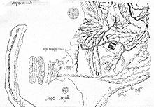
Anadyrski Ostrog
| place
Anadyrski Ostrog
Анадырский острог
|
||||||||||||||||
|
||||||||||||||||
|
||||||||||||||||
Anadyrski Ostrog ( Russian Анадырский острог ) or Anadyrsk (Russian Анадырск) was a fortified Russian outpost in Chukotka . It was founded in 1649 about 18 km upstream of today's settlement Markowo on the middle course of the Anadyr and abandoned in 1766.
history
In 1649 the Cossack troop of the explorer Semyon Deshnev built a hibernation hut on a two kilometer long and one kilometer wide island of the Anadyr after crossing the Bering Strait for the first time . The Cossacks came 1659/60 on the orders in the same place Kurbat Ivanov one Ostrog , which initially consisted of only a few huts with a picket fence surrounded. The place was used to negotiate with the elders of the indigenous peoples living here and to raise the Jassak . In the following years the fortifications were reinforced several times and the area of the ostrog enlarged. The strength of the garrison increased from 16 Cossacks in the winter of 1675/76 to 757 Cossacks and soldiers at the beginning of the 1760s. In 1732 the ostrog had the shape of a square with sides of 43 meters. Its wooden walls were eight feet high. He had a tower at each of the four corners and a fifth over the entrance gate. Outside the Ostrog there was a chapel (from 1746 a Church of the Redeemer ) and 80 residential buildings (1763: 130).
Anadyrski Ostrog was the most important base in northeast Siberia, from which the Russians controlled the area of the Yukagirs and Koryaks between the Anadyr in the north and the Gishigabusen and the Oljutorski Bay in the south. It was from here that Vladimir Atlasov conquered the Kamchatka Peninsula in 1697 . This increased the importance of the settlement, as it was initially the only way from Yakutsk to Kamchatka. The Ostrog was also the starting point of Dmitri Pavluzky's punitive expeditions against the rebellious Chukchi in 1731 and 1732 and the rebellious Koryaks in 1732. A new campaign against the Chukchi from 1744 ended near the Ostrog in 1747 with the defeat of the Cossacks and the death of Pavlutzki. In 1766, at the suggestion of their commander Friedrich Plenisner, the decision was made to give up the Ostrog and the settlement for reasons of cost. Until then, Anadyrsk had to be supplied with food and ammunition from Okhotsk by dog sledding . Again and again there had been famine among the Cossacks. The garrison and the residents withdrew to Gischiginsk . On March 3rd, 1771 the Ostrog and all houses were destroyed and burned down by the Russians. As early as 1784, Russified Jukagirs founded the village of Markowo nearby.
Web links
- А. С. Зуев: Анадырский острог in the history dictionary of Siberia (2009, Russian)
Individual evidence
- ↑ a b Peter Simon Pallas : Geographical description of the Anadyr River and the brooks falling into it . In: New Nordic supplements to the physical and geographical description of earth and peoples, Volume 1, No. 2, 1781, pp. 238–244.
- ↑ a b c d Зуев: Анадырский острог in the history dictionary of Siberia , 2009.
- ↑ Anadyr and Anadyrsk . In: Geographisches Lexicon , Appendix I in: Karl von Ditmar : Travel and stay in Kamtschatka in the years 1851–1855, Part 2, Saint Petersburg 1900, p. 219.
- ↑ TS Shentalinskaia: “Major Pavlutskii”: From History to Folklore. From the Materials collected by the American North-Pacific Expedition (PDF; 373 kB). In: SEEFA Journal . Volume 7, No. 1, 2002, pp. 3-21 (English). doi : 10.17161 / folklorica.v7i1.3714


