Gishiginsk
| city
Gizhiga
Гижигинск
|
||||||||||||||||||
|
||||||||||||||||||
|
||||||||||||||||||
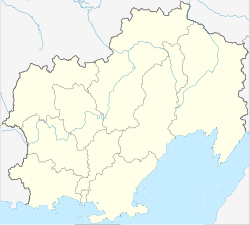
Gischiginsk ( Russian Гижигинск ), also Ischiginsk (Ижигинск) or Staraja Gischiga (Старая Гижига) is a former Russian city in Magadan Oblast . It was founded in 1752 on the left bank of the Gischiga , about 25 km from its confluence with the Gischiga Bay of the Sea of Okhotsk , and abandoned in 1926.
history
In 1752 the Cossack troop of Avraam Ignatjew built a wooden fort on the site of the later city of Gischiginsk . It had a rectangular base with sides of 64 and 43 m. There were log houses at two corners as additional fastening. Inside the fort there was the commandant's house and barracks for a garrison of 130 men. By 1758 the fort was expanded to a size of 278 × 181 m. It now had five towers and public buildings as well as a church. There was a port at the mouth of the Gischiga. After the abandonment of the Anadyrski Ostrog , the fort became the most important base of the Russian military and the Russian authorities in northeast Siberia in the 1760s. In the course of the administrative reform of Catherine II , Gischiginsk received town charter in 1782 and became the administrative center of the Ujesd of the same name in the then Okhotsk Oblast . Its importance also stems from the fact that it was on the land route between Okhotsk and the Kamchatka Peninsula. In 1790 the city got a two-part coat of arms. The lower part shows a fortress, on the central tower of which a flag with the name of Catherine II flies, the upper part a Siberian tiger , the heraldic animal of Irkutsk .
In the course of the 19th century the city lost its importance and had a more rural character. The inhabitants lived mainly from hunting and fishing . Vegetables were grown on a modest scale. As early as 1844 it was described as "poor". In 1926 Gischiginsk lost its town charter. The inhabitants left the place and settled near the mouth of the Gischiga in the village of Kushka, which was renamed Gischiga.
In the spring of 2016, it was proposed that the remains of the Gishiginsk cemetery should be declared a cultural heritage of Magadan Oblast.
| year | Residents |
|---|---|
| 1773 | 672 |
| 1805 | 773 |
| 1847 | 500 |
| 1885 | 200 |
| 1910 | 400 |
Source: Siberian History Lexicon , 2009
literature
- Alexander Mikhailovich Nikolski: Gischiginsk . In: Энциклопедический словарь Брокгауза и Ефрона - Enziklopeditscheski slowar Brokgausa i Jefrona . tape 8 a [16]: Германия – Го. Brockhaus-Efron, Saint Petersburg 1893, p. 659–662 (Russian, full text [ Wikisource ] PDF ).
Web links
- А. С. Зуев: Гижигинск (Ижигинск) In: History Lexicon of Siberia. (2009, Russian)
- Антон Афанасьев: Был такой город - Гижигинск (March 6, 2015, Russian)
Individual evidence
- ↑ J. Ch. Stuckenberg: Hydrography of the Russian Empire or geographical-statistical-technical description of its flowable and navigable rivers and lakes, its coasts, inner seas, ports and routes . tape 2 . Imperial Academy of Sciences, Saint Petersburg 1844, p. 716 ( limited preview in Google Book search).
- ↑ Перечень культурного наследия Колымы направили губернатору . In: Westi Magadan on May 13, 2016, accessed on November 19, 2016.


