Oymyakon
Village
|
||||||||||||||||||||||||||||
|
||||||||||||||||||||||||||||
|
||||||||||||||||||||||||||||
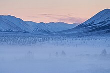
Oimjakon ( Russian Оймяко́н , Yakut Өймөкөөн / Öjmököön ) is a village (selo) in the Ulus of the same name in the east of the Sakha Republic (Yakutia) in the Far East of Russia . Oimjakon has 462 inhabitants (14 October 2010) and is next to Verkhoyansk with a minimum temperature of -67.8 ° C as the cold pole of all inhabited areas of the Earth . The name Oymyakon means something like "hot spring" in the Yakut language .
geography
Oymyakon is located about 680 km east-northeast of the city of Yakutsk in the highlands of Oymyakon in the valley of the Indigirka River at an altitude of about 675 m . The place lies between the elongated Verkhoyansk Mountains and the Tscherski Mountains . The mountain range that closes the highlands to the south prevents the influx of warmer air masses . The Suntar Chajata mountain range with the 2959 m high Mus Chaja runs 135 kilometers southwest of Oimjakon . To the west, the mountain range continues in the Verkhoyansk Mountains.
The village of Oimjakon belongs to Oimjakonski ulus and is located 125 km as the crow flies south of its administrative center Ust-Nera . The village is the seat of the rural community (selskoje posselenije) Borogonski 1-j nasleg, which also includes the two villages Bereg-Jurdja (5 km east, 178 inhabitants) and Chara-Tumul (a good 3 km northwest, 121 inhabitants). The community has a total of 761 inhabitants (October 14, 2010).
history
An old airport is available; it dates from the Second World War and was part of the route called ALSIB , through which several thousand aircraft of all types were handed over to the Soviet Union via Alaska under the lending and leasing law . After their departure in Alaska, a number of stopovers were necessary before the planes finally reached Europe. This made Oymyakon an important place for the Soviet Air Force and aviation fuel always had to be available in very large quantities to fill up the US aircraft. The airport is de facto no longer in operation.
From its establishment on May 20, 1931, Oimjakon was the administrative seat of the Oimjakonski rajon (Ulus) named after him . At the 1939 census, the place had 356 inhabitants. On June 3, 1954, the district administration was relocated to Ust-Nera, which was founded in the late 1930s and has meanwhile become more important, which had had the status of an urban-type settlement since 1950 .
Temperatures

Although Oymyakon is about 2900 km from the North Pole , here (long-term weather station in the village of Tomtor , 30 km southeast ( 63 ° 16 ′ N , 143 ° 12 ′ E ) , since 2004 with its own weather station in Oymyakon) the lowest temperatures of all inhabited areas have been recorded of the earth ( cold pole of all habitable areas of the earth, see highlands of Oymyakon ). The extreme values are favored among other things by the topographical conditions in these highlands.
The lowest temperature is currently recognized as −67.8 ° C (February 6, 1933) (same value as in Verkhoyansk ). The −71.2 ° C from 1926 on the Kaltepol monument in Oymyakon are not recognized. Allegedly the value was not measured, but extrapolated by an academy member. In the area around Oymyakon there are very often very pronounced cold spikes . The WMO index number of the weather station is 24688.
On the other hand, in summer it can get over +30 ° C, which means that temperature differences of more than 100 ° C are possible in one year. On July 28, 2010, a new temperature maximum of 34.6 ° C was measured, which was 2 ° C above the previous maximum.
| Oymyakon | ||||||||||||||||||||||||||||||||||||||||||||||||
|---|---|---|---|---|---|---|---|---|---|---|---|---|---|---|---|---|---|---|---|---|---|---|---|---|---|---|---|---|---|---|---|---|---|---|---|---|---|---|---|---|---|---|---|---|---|---|---|---|
| Climate diagram | ||||||||||||||||||||||||||||||||||||||||||||||||
| ||||||||||||||||||||||||||||||||||||||||||||||||
|
Average monthly temperatures and rainfall for Oymyakon
|
|||||||||||||||||||||||||||||||||||||||||||||||||||||||||||||||||||||||||||||||||||||||||||||||||||||||||||||||||||||||||||||||||||||||||||||||||||||||||||||||||||||
swell
- ↑ a b Itogi Vserossijskoj perepisi naselenija 2010 goda. Tom 1. Čislennostʹ i razmeščenie naselenija (Results of the All-Russian Census 2010. Volume 1. Number and distribution of the population). Tables 5 , pp. 12-209; 11 , pp. 312–979 (download from the website of the Federal Service for State Statistics of the Russian Federation)
- ↑ Itogi Vserossijskoj perepisi naselenija 2010 goda. Tom 1. Čislennostʹ i razmeščenie naselenija (Results of the All-Russian Census 2010. Volume 1. Number and distribution of the population). Tables 5 , pp. 12-209; 11 , pp. 312–979 (download from the website of the Federal Service for State Statistics of the Russian Federation)
- ^ World Meteorological Organization Global Weather & Climate Extremes
- ↑ ( page no longer available , search in web archives )
- ↑ The hot summer of 2010 in Russia. Part 1: Forest and moor fires. Compiled by Werner Wehry. In: Contributions to the Berlin weather map . BERLINER WETTERKARTE eV association for the promotion of meteorological science, 47/2010. ISSN 0177-3984 .


