
Lena (Arctic Ocean)
|
Lena Лена, Өлүөнэ, Ölüöne |
||
 Course of the Lena in eastern Siberia |
||
| Data | ||
| Water code | RU : 18030900112117500000010 | |
| location | Irkutsk Oblast and Sakha Republic (Yakutia), Siberia , Russia , Asia | |
| River system | Lena | |
| source | in the Baikal Mountains near Lake Baikal 53 ° 55 ′ 58 ″ N , 108 ° 5 ′ 5 ″ E |
|
| Source height | 1465 m | |
| muzzle | within the Lena Delta in the Laptev Sea ( Arctic Ocean ) Coordinates: 72 ° 24 ′ 2 ″ N , 126 ° 41 ′ 31 ″ E 72 ° 24 ′ 2 ″ N , 126 ° 41 ′ 31 ″ E |
|
| Mouth height | 0 m | |
| Height difference | 1465 m | |
| Bottom slope | 0.34 ‰ | |
| length | 4294 km | |
| Catchment area | 2,490,000 km² | |
| Discharge at the Krestovskoe A Eo gauge : 440,000 km² Location: 2,655 km above the mouth |
MQ 1936/1999 Mq 1936/1999 |
4165 m³ / s 9.5 l / (s km²) |
| Discharge at the Tabaga A Eo gauge: 897,000 km² Location: 1527 km above the estuary |
MQ 1936/1999 Mq 1936/1999 |
7007 m³ / s 7.8 l / (s km²) |
| Discharge at the Kusur gauge (Kjussjur) A Eo : 2,430,000 km² Location: 211 km above the mouth |
MQ 1934/2000 Mq 1934/2000 |
16,760 m³ / s 6.9 l / (s km²) |
| Discharge at the Stolb A Eo gauge : 2,460,000 km² Location: 4.7 km above the mouth |
MQ 1976/1994 Mq 1976/1994 |
15,381 m³ / s 6.3 l / (s km²) |
| Left tributaries |
Wiljui (this and others see below ) |
|
| Right tributaries |
Witim , Oljokma , Aldan (these and others see below ) |
|
| Big cities | Yakutsk | |
| Navigable | from Ust-Kut (3,500 km) | |
.jpg) Lena near Yakutsk |
||
The Lena ( Russian Лена ; Yakut Өлүөнэ , Ölüöne ) is a river in Siberia in the Asian part of Russia . It flows into the Laptev Sea , a marginal sea of the Arctic Ocean . The Lena is from the source to the Lena Delta km long 4294, on the water-rich Deltaarm Bykowsskaja Protoka is as high as 4400 km in total. It is one of the longest rivers on earth .
course
The Lena rises a little more than five kilometers northwest of Lake Baikal in the Baikal Mountains . Its source is 1465 m above sea level on the western flank of a 2023 m high mountain - in the unpopulated area of the Baikal-Lena nature reserve . In 1997, on the occasion of the 250th birthday of the metropolitan Innokenti of Moscow , who came from this area , a wooden chapel was built in his honor directly at the Lena spring .
Initially, the Lena flows a little north. From roughly the point where it falls below the 1000 m contour line , it runs in a west-south-west direction to Birjulka ( 555 m ) and then westwards to Katschug ( 510 m ). Then the Lena, after changing from the Baikal Mountains to the Lena Angara Plateau , flows a bit to the northwest and north and through Schigalowo ( 410 m ). Before Ust-Kut ( 285 m ) it turns for a bit to the west and before the city turns in an elongated river loop first to the east and then to the northeast. The river is navigable from Ust-Kut . Then at Kirensk ( 248 m ), from where the Lena runs parallel to the Lower Tunguska, which is heading towards the Yenisei and only a few kilometers southeast of this, the Kirenga , which also rises near Lake Baikal, joins . It changes from the Lena-Angara-Plateau to the Central Siberian mountainous region (max. 1701 m ).
After that, the Lena flows in Vitim ( 185 m ) of the light coming from the south Vitim to. A little later, the river at Lensk ( 160 m ) makes an elongated right curve north around the Patom highlands (max. 2148 m ). The Lena turns a bit to the southeast and takes in the Oljokma flowing from the south a little below Oljokminsk ( 125 m ) . From now on it flows to the east-northeast. After taking up the Sinjaja near Sinsk ( 100 m ) and then passing the Lena rocks , it reaches the Central Yakut lowland past Pokrovsk ( 94 m ) to Jakutsk ( 92 m ). After that, the Lena flows first the Aldan, which ultimately comes from the east-southeast, and then, after passing Sangar ( 65 m ) below the former village of Tas-Tumus ( 57 m ), from the west to the Wiljui . In this region the river runs between the Verkhoyansk Mountains (max. 2959 m ; in the east) and the Central Siberian mountainous region (in the west) - mainly in a south-north direction.
A little further to the northwest, coming from the west for its last kilometers, the Linde and after passing Schigansk ( 32 m ) from the same direction the Muna joins the Lena. A little further north-northeast the Molodo flows into Siktjach ( 12.5 m ) . Further northeast, the Lena flows from about Kjussjur ( 6.5 m ) between the northern foothills of the Verkhoyansk Mountains in the east and the Czekanowskibergen (max. 539 m ) (northeast part of the Central Siberian Mountains) in the west.
Finally, the Lena reaches the approximately 45,000 km² Lena Delta , which measures a maximum of 230 km from west to east and up to 150 km from north to south. After flowing through this widely ramified estuary delta , your water reaches the Laptev Sea , a marginal sea of the Arctic Ocean .
Lena rocks
Viewed upstream, about 90 km west-southwest of Pokrovsk or 150 km (as the crow flies ) south-west of Yakutsk , the Lena rocks rise in an unpopulated area on the Lena ( ⊙ ). The Cambrian rocks extend a little below the Sinjaja, which flows in from the north, along the south bank of the river, which runs there at a height of about 99 m to 96 m , for about 80 km. They reach a maximum height of around 300 m and their hinterland close to the river a maximum of around 328 m . The rocky landscape is located in the Lenafelsen Nature Park , which was founded in 1995 and is 4850 km² in size, and was designated a World Heritage Site by UNESCO in 2012 . To the south, the landscape leads over to the Buotama River , which flows into the Lena a little above Pokrovsk.
Catchment area and tributaries
The catchment area of the Lena corresponds with 2,490,000 km² nearly seven times the area of Germany . The discharge , which varies between 2,800 m³ / s in January and 66,500 m³ / s in June , is mainly due to the melting of the ice between May and June.
The minimum ever measured discharge of the Lena (level Kjussjur on the lower reaches) of 366 m³ / s was recorded on April 27, 1940, the maximum discharge of 220,000 m³ / s on June 4, 1989. In June 1989 the maximum discharge was recorded there of 104,000 m³ / s on a monthly average.

| Tributaries |
|---|
The following list includes larger tributaries of the Lena, viewed downstream: Names of rivers at least 1000 km long are bold, the orographic assignment (l = left-hand side; r = right-hand side), the length in kilometers (km), the location of the mouth, the Lena river kilometers above the confluence with the Laptev Sea and - if known - the catchment area of the tributary in square kilometers (km²):
|
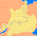
Catchment area of the Lena

The Lena rocks south of Yakutsk

Lena near Yakutsk
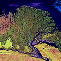
The Lena Delta (NASA Landsat Project)

Ice road over the Lena


Localities
The localities (including former ones ) on the Lena and near the Lena Delta include downstream - with approximate bank heights in meters (m) above sea level (cities in bold , villages that no longer exist in italics , administrative offices of Rajons / Ulussen and urban districts marked with *) :
At the Lena:
|
|
Near the Lena Delta:
- Tiksi * (10 m), coastal and harbor town on the Laptev Sea (about 55 km east of the Lena and a good 20 km south of the eastern part of the Lena Delta)
The villages up to and including Alexejewsk are in the Irkutsk Oblast , all others in the Republic of Sakha (Yakutia) .
Climate and navigability
The Lena is usually frozen over from October to June of the following year so that it can be used as an ice road . When the ice melts, the Lena becomes a torrent and its water level can rise by 25 meters. Particularly devastating effects are the ice blockages , the consequences of which in May 2001 devastated the city of Lensk and large parts of Yakutsk were flooded. When the river is ice-free, the Lena is navigable from Ust-Kut to its large estuary delta over a length of 3500 km .
literature
- Tatiana Kuschtewskaja : Siberia trip - the Lena. From Baikal to the Arctic Ocean - history and stories along the great Siberian river. Wostok-Verlag , Berlin 2007, ISBN 978-3-932916-36-6 .
Web links
- Article Lena in the Great Soviet Encyclopedia (BSE) , 3rd edition 1969–1978 (Russian)
- Hydrographic measuring points in the catchment area of the Lena and neighboring river systems
References and comments
- ↑ a b c d e Lena in the State Water Register of the Russian Federation (Russian) - with tributaries (part 1)
- ↑ Lena at the Krestovskoe gauge - hydrographic data from R-ArcticNET
- ↑ Lena at the Tabaga gauge - hydrographic data at R-ArcticNET
- ↑ Lena at the Kusur gauge - hydrographic data at R-ArcticNET
- ↑ Lena at the Stolb gauge - hydrographic data at R-ArcticNET
- ↑ Lena River , in: Encyclopedia of the Artic, accessed on August 5, 2017, from books.google.de
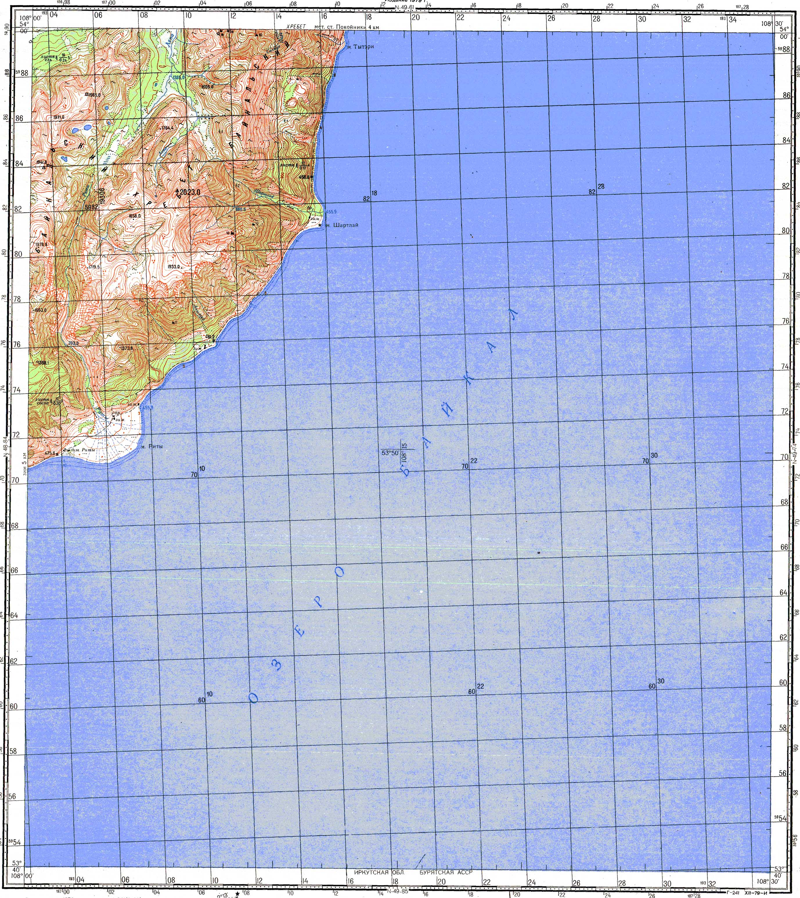
- ↑ Topographic map sheet N-49-73 ( scale 1: 100,000), u. a. with Lenaquelle (top left; Лена) near Lake Baikal on the western flank of a 2023 m high mountain in the Baikal Mountains , on vlasenko.net
- ↑ Photo of the chapel
- ↑ Сергей Волков. По Байкалу
- ↑ a b The heights given in the sections “Course” and “Localities” are approximate bank heights, but not heights of the localities / centers.
- ↑ Topographic map, sheet P-52-25,26 (scale 1: 100,000), u. a. with Lena rocks (on the south bank of the Lena; top right), the Lena (Лена) and the Buotama , which flows a little south of it , on vlasenko.net
- ↑ UNESCO World Heritage Center: Lena Pillars Nature Park
- ↑ A. Alekseevskij et al . Лена (PDF) p. 73.
- ↑ Lena in the state register of waters of the Russian Federation (Russian) - with tributaries (part 2)
- ↑ Lena in the state register of waters of the Russian Federation (Russian) - with tributaries (part 3)
- ↑ Lena in the State Water Directory of the Russian Federation (Russian) - with tributaries (part 4)