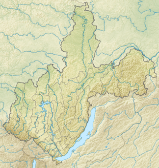
Patom highlands
| Patom highlands | ||
|---|---|---|
| Highest peak | Longdor ( 2148 m ) | |
| location | Irkutsk Oblast and Sakha Republic , Siberia ( Russia , Asia ) | |
| part of | South Siberian Mountains | |
|
|
||
| Coordinates | 59 ° 0 ′ N , 115 ° 0 ′ E | |
The Patomhochland ( Russian нагорье Патомское , Patomskoje nagorje ) in the Irkutsk Oblast with North foothills in the Republic of Sakha ( Yakutia ) in Siberia , Russia ( Asia ) is one to 2148 m high mountains of the South Siberian mountains .
Geographical location
The Patom Highlands are located north of the Stanovoi Highlands and south of the Central Siberian Mountains . It is located south of an elongated arch of the Lena between its tributary Witim in the west and southwest, the Witim tributary Sygykta in the southeast and the Oljokma tributary Tschara in the east. The northern foothills of the highlands, which are otherwise in the Irkutsk Oblast, extend in the direction of the Lena to the Sakha Republic.
The highlands are on average 1400 to 1900 m high. Its highest mountain is 2,148 meters directly north lying in his southern part of the Sygykta Longdor . Much further north, near the headwaters of the Tschentscha, lies a 1916 m high mountain, which is sometimes called the highest point.
The localities in the highlands or on the outskirts include Bodaibo , Lensk , Maza , Mama , Nuja , Peledui , Perewos , Swetly and Witim .
Individual evidence
- ↑ a b Patom highlands in the Encyclopedia of Transbaikaliens (Russian)
literature
- B. Vvedensky et al: Bolshaya sovetskaya enziklopedija: Tom 32 . Isd-wo Bolschaja sovetskaja enziklopedija, Moscow 1955, p. 232 (Russian)
