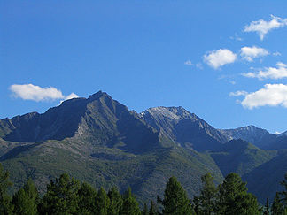
Stanowoi Highlands
| Stanowoi Highlands | ||
|---|---|---|
|
View from the Baikal-Amur-Magistrale (BAM) to mountains in the Northern Muja Mountains belonging to the Stanowoi Highlands |
||
| Highest peak | BAM of Spades ( 3072.6 m ) | |
| location | Republic of Buryatia , Siberia ( Russia , Asia ) | |
| part of | South Siberian Mountains | |
|
|
||
| Coordinates | 56 ° 35 ' N , 116 ° 47' E | |
The Stanovoy Highlands ( Russian Становое нагорье , scientific. Transliteration Stanovoe nagor'e ) in Siberia ( Russia , Asia ) is one to 3072.6 m high mountain system of the South Siberian mountains . The Stanowoi Mountains are about 670 km to the east-southeast .
geography
location
The Stanowoi highlands are located northeast of Lake Baikal , north of the Witim plateau and south of the Patom highlands . The mountain system, about 500 km long in east-west direction, in which the Upper Angara rises, is traversed by the Witim and limited in the east, at the transition to the northern Aldan highlands , by the Oljokma .
Mountain parts
The Stanovoi highlands include several mountains, separated by broad tectonic depressions (such as the Upper Angarasenke , Mujasenke , Obere Tscharasenke ) and sometimes relatively clearly delimited: Upper Angaragebirge , Deljun-Uran-Berge and Kodargebirge in the north, to the south of them the Northern Mujagebirge ( Severo-Muisker) -Gebirge ), Southern Mujagebirge (Juschno-Muisker mountains), Udokangebirge and Kalargebirge .
mountains
The highest mountains in the Stanovoi Highlands are the BAM peak in the Kodar Mountains, at 3,072.6 m , which got its unofficial name because of the Baikal-Amur Mainline (BAM) railway line running close to the mountains , and at 3,067.1 m (formerly 2721 m ) the Muja-Gigant (Russian Muiski Gigant ; also unofficial name; first ascent 1993) in the southern Muja Mountains.
Individual evidence
- ↑ a b Topographic map (1: 100.000, Bl. O-50-116, Ed. 1985, Sallikit ), part of the Kodar Mountains and a. with Pik BAM (middle left) as well as Upper Sakukan (middle) and Middle Sakukan (above) and part of the Upper Charasenke (below) with the Tschara (right below) and Baikal-Amur Magistrale (middle below to right below), on mapo50 .narod.ru (with heights above sea level )
Web links
- Ascent of the Muja Giant (2005; Russian; with photos)

