Siberia
As Siberia ( Russian Сибирь / Sibir ) is known throughout the North Asian part of the broadly Russian Federation . It is bounded to the west by the Urals , to the north by the Arctic Ocean , to the east by the Pacific and to the south by the People's Republic of China , Mongolia and Kazakhstan . Siberia covers around three quarters of the Russian territory and is about 13.1 million square kilometers; thus it is around 3.5 million km² larger than the People's Republic of China (approx. 9.6 million km²), the largest independent state in Asia.
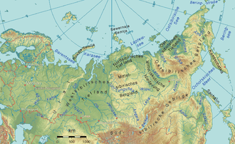
In a narrower sense , Siberia is understood to mean five of the eight major Russian landscapes: the great West Siberian Lowland , the North Siberian Lowland , the Central Yakut Lowland , the Central Siberian Mountains and the South Siberian Mountains .
Eastern Siberia (two other large landscapes east of the Lena ) and the south-easternmost areas of Russia between the Amur and the Pacific coast are also known as the Russian Far East (Federal District Far East).

Geographic overview
Large landscapes
In common usage, Siberia is the north of Asia, which belongs to Russia, from the Ural Mountains to the coast of the Pacific Ocean . It extends in a west-east direction about 7000 kilometers from the Urals to the mountains of the Pacific watershed . From north to south it spans about 3,500 kilometers from the Arctic Ocean ( Arctic Ocean ) to the Kazakh hill country and the border with Mongolia and the People's Republic of China .
Siberia can be roughly divided into seven major landscapes:
- West Siberian lowlands , between the Ural Mountains and the Yenisei River .
- North Siberian lowlands , near the Arctic Ocean from the mouth of the Yenisei to the mouth of the Lena .
- Central Siberian mountains , apart from the Putorana Mountains below 1000 meters high, south of the North Siberian lowlands, between Yenisei in the west and Lena in the east.
- Central Yakutian lowland (with the Lena), between Central Siberian mountains in the west, South Siberian mountains in the south and East Siberian mountains in the east.
- South Siberian Mountains , group of high mountains south of Central Siberian Mountains and Central Yakut Lowlands, between the Djungarian Gate in the west and the Sea of Okhotsk in the east, bordering Mongolia to the south and separated and cut through by the Amur Valley from Chinese Manchuria. Heights of up to 4506 m ( Belucha in Altai ) to a little over 2000 m near the Pacific coast.
- East Siberian mountainous country , with several mountain ranges over 2000 m high, adjoining the South Siberian mountains without a dividing incision, east of the Central Yakutian Lowlands and Lena, north of the Sea of Okhotsk and west of the Bering Sea . As an extension of this mountainous country, the approximately 1200 km long Kamchatka peninsula extends south into the Pacific and separates the Sea of Okhotsk in the west from the Bering Sea in the east.
- East Siberian lowlands (with Jana Indigirka lowlands and Kolyma lowlands ), enclosed in the west, south and east by the East Siberian highlands.
Administrative division

Originally, the country name Siberia referred to the Siberian Khanate in what is now Western Siberia , a split from the Khanate of the Golden Horde .
In today's Russian administrative system, Western Siberia and the Urals make up the Russian Ural Federal District . This is followed to the east by the federal district of Siberia , which includes most of the central Siberian mountainous region and the southern Siberian mountains. To the east borders the Far East Federal District .
This Russian Far East ( Да́льний Восто́к / Dalni Wostok ) stretches from Yakutia to the Pacific coast and is around 6.18 million km² larger than the federal district of Siberia. Although it is mostly subsumed as part of this landscape outside of Russia, it is considered a separate region in Russia itself. For example, residents of Kamchatka or Sakhalin understand “Siberia” to be a region several thousand kilometers west of their homeland. For Russians, Siberia begins "behind the Urals" - at the level of Tyumen - and ends "just behind the Baikal" - about 100 kilometers east of Lake Baikal, near Ulan-Ude .
rivers and lakes
The Lake Baikal is located in the South Siberian mountains, with 1642 m depth of the deepest lake and with a volume of 23,615 cubic kilometers of water-rich freshwater lake in the world. It contains about a fifth of the world's liquid freshwater.
Rivers that flow into the polar sea
- The 3650 km long Ob has an average discharge of approx. 13,000 m³ / s (1995) and drains 2.43 million km² of Western Siberia and Kazakhstan into the Arctic Ocean . It rises as Katun in the Altai Mountains . It has a 1000 km long and up to 60 km wide estuary , the obbus . Its main tributaries are from south to north:
- The Tschulym , 1799 km long right tributary, comes with its right source river Weißer Ijus to 2023 km. Both arise in the Sajan Mountains .
- The Irtysh , 4248 km long left tributary, rises on the south side of the Mongolian Altai in Djungaria , reaches Kazakhstan through the Djungarian Gate and only 1,500 km further on Siberia.
- The 2450 km long Ischim , left tributary of the Irtysh, comes from the Kazakh steppe and only reaches Siberia in the lower reaches.
- The other left tributary Tobol , 1591 km long, has its source in the southeastern foreland of the Ural Mountains in Kazakhstan. More than half of its course is on Russian territory.
- The 4092 km long Yenisei has an average discharge of approx. 20,000 m³ / s (1995) and drains 2.44 million km² of Siberia and Mongolia . Its estuary is about 500 km long. Its main tributaries flow from the right. List in descending order of the mouths:
- The Angara is the only outflow from Lake Baikal. It leaves the lake not far from its southern end and flows in a north-westerly direction through the Irkutsk reservoir , at whose dam is Irkutsk . A little further north of this city, in which the Irkut coming from the southwest joins, it passes Angarsk. A few kilometers below the city, the Angara flows through the large Bratsker reservoir , where it flows into the extreme south of the Central Siberian Mountains. In the lake, the Oka, coming from the southwest, flows towards it, roughly where it reaches the city of Bratsk . The Angara is navigable between Irkutsk and Bratsk.
- The Selenga is a tributary of Lake Baikal and thus a tributary of the Angara. The top two thirds of their run belong to Mongolia.
- The stony Tunguska is 1865 km long.
- The 2989 km long Lower Tunguska rises 100 km southeast of the Stony Tunguska and is only separated from the Lena valley by a ridge in the upper reaches. It flows into the Yenisei 600 km downstream of the Stony Tunguska.
- The Angara is the only outflow from Lake Baikal. It leaves the lake not far from its southern end and flows in a north-westerly direction through the Irkutsk reservoir , at whose dam is Irkutsk . A little further north of this city, in which the Irkut coming from the southwest joins, it passes Angarsk. A few kilometers below the city, the Angara flows through the large Bratsker reservoir , where it flows into the extreme south of the Central Siberian Mountains. In the lake, the Oka, coming from the southwest, flows towards it, roughly where it reaches the city of Bratsk . The Angara is navigable between Irkutsk and Bratsk.
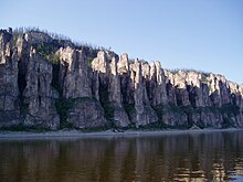
- The Olenjok is a 2292 km long river in the Krasnoyarsk region and in Yakutia, which rises in the Central Siberian mountains.
- The 4400 km long Lena rises only about 5 km from the central west bank of Lake Baikal in the arch between the lake and the Angara. It drains 2.46 million km² and carries an average of 16,400 m³ / s (1994) in its 200 km wide delta into the Arctic Ocean , here called Laptev Sea . Their largest tributaries are in descending order of confluence:
- The heavily twisted Witim rises east of Lake Baikal in the mountains between the lake and the Ingoda . It is 1968 km long.
- The 1436 km long Oljokma rises between Witim and Schilka and is also a mountain river for its entire length.
- The 2273 km long Aldan rises on the north side of the Stanowoy Mountains , describes a wide arc around Yakutsk and reaches the Lena in the Central Yakut lowland .
- The Wiljui comes from the Central Siberian mountainous region and, with a length of 2650 km, is the only large left tributary of the Lena, even by Siberian standards.
- The 872 km long Jana flows east of the Lena between the Verkhoyansk Mountains and Tscherski Mountains . It arises from the union of Dulgalach and Sartang and together with the latter is 1492 km long. The Jana region with the city of Verkhoyansk (next to Oymyakon on the Indigirka) is considered to be the cold pole of Russia and the coldest inhabited area on earth.
- The Indigirka , which rises north of the Sea of Okhotsk, is 1726 km long, with its source river Chastach 1977 km. More than half of it flows through the East Siberian high mountains before reaching the lowlands and then flowing into the East Siberian Sea with a 100 km wide delta .
- The better known Kolyma , 2129 km long, has its source in the same mountain range and flows 400 km east of the Indigirka with an estuary divided like a delta. It drains 526,000 km² and its annual runoff was about 2728 m³ / s.
Rivers that flow into the Pacific

- The Amur forms since 1858/1860 along with its source river Argun (1620 km) and its tributary the Ussuri most of the (East Asian) border between Russia and China. Below the mouth of the Ussuri, it only flows northwards through Russian territory. The Amur is 2824 km long, with its source river Schilka (555 km) and its longer source river Onon (1032 km) hydrologically even 4411 km. Its main tributaries are from west to east:
- The 1208 or 1242 km long Seja comes from the Stanowoy Mountains in the north.
- The 1927 km long Songhua Jiang , or Sungari in Russian , is located with its catchment area completely outside Russia and drains the northern half of Manchuria and the far east of Inner Mongolia
- The 588 km long Ussuri rises east of Vladivostok in the south of the Sichote-Alin Mountains only a few kilometers from the coast and reaches the Amur near Khabarovsk .
- The 1,146 km long Anadyr is the easternmost stream in the Old World and one of the northernmost. Its catchment area covers 191,000 km². It rises 50 km north of the Arctic Circle and flows after a curved course 400 km as the crow flies southeast of its source with an estuary into the Bering Sea .
climate
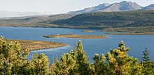
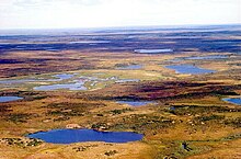
Most regions of Siberia have a pronounced continental climate : Relatively hot summers (up to +40 ° C) are replaced by extremely cold winters (down to −72 ° C). The country is often covered by a blanket of snow for up to nine months. The landscape is largely dominated by boreal forests (taiga), while treeless tundra predominates in the arctic regions . In between there is a transitional form with the forest tundra zones. In the south the taiga turns into steppe.
Large parts of Siberia are occupied by permafrost (permanently frozen ground ), which only thaws superficially in the warm season. Dew and rainwater cannot seep away there. The waterlogging leads to an extreme abundance of mosquitoes in the short summer . The fact that the ground under buildings and traffic routes thaws more than normal creates considerable problems in their construction and maintenance. In addition to the tundra, the permafrost area also includes large parts of the taiga and extends east of Lake Baikal to its southern edge - and the southern border of the Russian national territory. About a third of Siberia has uninterrupted permafrost, especially the Sakha Republic ( Yakutia ) and its north-western and north-eastern neighboring areas. About half of Siberia has permafrost soils in addition to completely thawing areas. Only the extreme southwest and narrow strips of territory on the central Amur and on the Pacific coast have no permafrost at all.

The cold pole of the inhabited world is in Oymyakon in eastern Siberia (south of Verkhoyansk ).
The climate change has significant consequences in Siberia. It shows up less in the rise in average temperature than in the accumulation of extreme weather phenomena. In July 2019, for example, there were massive floods in the Irkutsk region. In particular, the republics of Yakutia and Buryatia and the regions of Krasnoyarsk and Irkutsk were affected by forest fires in the summer of 2019 , in which three million hectares of forest (more than the size of Brandenburg) had been destroyed by the end of July of that year.
flora
From north to south Siberia is divided into tundra , taiga , forest steppe and steppe. The tundra is mostly flat. Mainly small shrubs, grasses, upholstery and moss plants and lichens grow there . The taiga is largely flat. There are coniferous forests, swamps and peat bogs . Spruce and pine dominate in the west, larches in the east . The forest steppe is flat to undulating. There is often erosion here and the snow cover is very thin. In the steppe there are many grasses and herbs, in the forest steppe there are mainly birch trees .
Due to climate change and the (associated) intrusion of pests, but also through human use, the tree population is subject to change.
fauna
The mammals of Siberia in the northern tundra include reindeer , polar bears , walruses , seals , lemmings and arctic foxes .
In the taiga you can meet brown bears , black bears , wolves , sables , squirrels , polecats , ermines , foxes , otters , lynxes , elks , hares , wild boars , badgers , wolverines and many species of birds.
Leopards and tigers are mainly found along the Amur .
history
Population, settlement
With 38 million inhabitants, Siberia is only sparsely populated; the average population density is only 2.9 people per km². The population is concentrated in a relatively narrow strip in the south and south-west, where the Trans-Siberian Railway connects important cities and where agriculture is possible.
Novosibirsk , Omsk , Krasnoyarsk , Tyumen , Tomsk , Irkutsk , Khabarovsk , Chita , Ulan-Ude and the Far Eastern Pacific metropolis Vladivostok are among the largest cities in this strip. Important industrial centers in which other large cities are located are the Khanty and Mansi Autonomous Okrug and the Yamal-Nenets Autonomous Okrug , which represent the focus of the oil and gas industry, as well as the South Siberian Kuznetsk coal basin ( Kuzbass ) with the industrial cities Novokuznetsk and Kemerovo .
Colonization
|
Ostrogs and cities in the Urals and Siberia The year in the left column usually indicates the founding of the Ostrog. |
|
| 1574 | Ufa (west of the Urals; after conquering Bashkiria ) |
| 1586 | Tobolsk (1621 bishopric) on the Irtysh |
| Tyumen (1782 city) | |
| 1604 | Tomsk am Tom , near the confluence with the Ob |
| 1618 | Kuznetsk , today Novokuznetsk , on the Ob |
| 1619 | Yeniseisk , municipal law 1635 |
| 1621 | Krasnoyarsk on the Yenisei |
| 1632 | Yakutsk on the Lena |
| 1636 | Bratsk on the Angara |
| 1644 | Jarmanka on Kolyma , 1755 city of Srednekolymsk |
| 1647 | Okhotsk on the Pacific coast |
| around 1650 |
Anadyr far upstream from today's Pacific port of Anadyr |
| 1653 | Neljudski later Nertschinsk , City 1689 |
| Tschita (winter camp, fort only 1690) | |
| 1661 | Irkutsk , Upper Angara , near Lake Baikal |
| 1666 | Ulan-Ude (1775 city) |
| 1716 | Omsk on the Irtysh |
| 1723 | Yekaterinburg (Urals, area developed by Novgorod since the 11th century ) |
| Perm (west of the Urals, city 1780) | |
| 1730 | Barnaul (1771 city) on the Lena |
| 1735 | Orsk ( Ural River , securing the southern border) |
| 1736 | Chelyabinsk (1781 city) |
| 1740 | Petropavlovsk-Kamchatsky |
| 1743 | Orenburg ( Ural River , securing the southern border) |
| 1754 | Zlatoust (Ural Mountains; city 1865) |
| 1850 | Nikolayevsk-na-Amure |
| 1858 | Khabarovsk on the Amur |
| 1860 | Vladivostok on the Pacific coast |
| 1893 | Novosibirsk on the Ob |
| 1935 | Norilsk near the estuary of the Jenissei |
In the Ural Mountains there had been trading and mining branches of the Novgorod Republic since the 11th century . East of the Russian settlement area as far as the Urals there was later the semi-autonomous territory of the Stroganov merchant family . It formed the starting point for the conquest and development of Siberia. It began around 1580 with the expedition of the Cossack Yermak . In 1582 the Cossacks conquered the Siberian Khanate , which until then had ruled Western Siberia from the Ural Mountains to the Yenisei .
After that, Russian power was rapidly expanded to the east, initially staying relatively far north in order to avoid conflicts with the states of Central Asia and with Manchuria , which was conquering China at the same time. In 1639 the Russians reached the Pacific coast for the first time . It was not until 1858 to 1860 that the Amur region, which was somewhat milder in climate, became part of the Russian Empire through the annexation of Outer Manchuria .
A wide-meshed network of wooden forts, so-called ostrogs , was built early on . The more intensive development extended into the 20th century. Important measures were the creation of the Siberian tract in the 18th century and the construction of the Trans-Siberian Railway from 1891 to 1916.
Even under the tsars , many politically unpopular people were exiled to Siberia . There was only much less development by independent settlers than in the English colonies in North America, since a large part of the population of Russia were serfs and the Russian nobility did not want to lose them through emigration.
The founding dates of Siberian cities give an idea of the development, see the adjacent list.
Historical demographic development
The majority of the population are the Russians who immigrated in the last centuries . Already in the 18th century they outnumbered the indigenous population . The remote and inhospitable areas of Siberia and Central Asia were already used to banish political opponents and criminals during the times of the Tsars. The gulags , the system of prisons and penal camps established under Stalin's rule , achieved terrible fame . The deportations to these areas only stopped when the Soviet Union collapsed . From the 1920s the industry of Siberia was accelerated, which fixed the population structure in favor of the immigrants.
From 1926 to 1927 the young Soviet state attempted to gain a more detailed overview of the peoples and culture of the polar region.
During the Second World War , entire industrial plants were brought to safety from the German advance into Siberia, and hundreds of thousands of people were resettled there in connection with this.
Indigenous people of Siberia
The indigenous peoples of the North, Siberia and the Russian Far East are made up of peoples of the Altaic and Ural language families as well as the Paleo-Asian languages and others. The larger are the Tuvins , Buryats , Khakass , Yakuts and Altai . The smaller ethnic groups without their own republic include a. Chukchi , Evenki , Evenen , Koryaks , Nenets , Chanten and Mansi as well as the Jukagirs . In the Soviet Union , most of the indigenous peoples of Siberia were affected by the forced settlement and collectivization in sovkhozes .
The greatest threat to the indigenous peoples comes from the industrial development of mineral resources such as oil, gas, coal, diamonds and gold in the Asian part of Russia. In addition, alcoholism is a huge problem. The languages of many smaller peoples are on the verge of extinction, especially where the environment in which they are used is lost due to industrial development.
Current demographic developments
Like many industrialized nations, Russia is suffering from a decline in its own population. Although metropolitan areas such as Moscow and Saint Petersburg continue to grow today, regions such as Siberia or the Far East are facing an increasing population decline due to emigration (to larger cities or even abroad), stagnating life expectancy and fewer births. The population curves typically show an increase from the 1940s to 1990 and a decrease from 1990 to the present. In sub-polar regions, the greater the proportion of European immigrants, the greater the fluctuation. In some cases, a more than three-fold increase was followed by a decrease to a little more than the initial value.
In the border area with the People's Republic of China , there has been increased trading activity since the early 1990s, as it is now easier for Chinese traders to commute between the two countries. It is estimated that there are several hundred thousand Chinese immigrants who settle on the Russian side, often temporarily, but sometimes also for an indefinite period of time. More and more of the new immigrants are drawn to the larger cities in Siberia, such as B. to Irkutsk . The native Russian population is skeptical about this development, which is also propagated by the official side of Russian politics. There are fears about an expansive settlement policy on the part of the Chinese as well as a threat to security along the up to 3000 km long common border, e.g. B. through smuggling of raw materials, drugs, weapons, crime and illegal immigration.
"Federalization of Siberia"
In connection with the 2014 Crimean crisis , warnings were issued against the danger of promoting separatism in Russia. In Novosibirsk in August 2014, for example, a planned “March for the federalization of Siberia” was banned in order to “guarantee the territorial integrity and sovereignty of Russia”.
Heatwave
In 2020 there was a heat wave in Siberia, which among other things led to the diesel oil disaster near Norilsk . For months, the temperatures were well above normal.
economy
raw materials
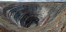
In addition to the extraction of natural gas and oil, the timber industry, coal, uranium, diamond and gold mining represent the most important uses of natural raw materials in Siberia. Siberia therefore has a great influence on the energy industry in Russia as well as on the general economic policy of Russia .
Fur animals
The importance of fur hunting today is mainly to be viewed historically; fur farming has also been abandoned in many places for economic reasons, for example in Ust-Port .
Wood
Lessosibirsk is the Russian "capital of the timber industry" on the Yenisei not far from the mouth of a tributary, the Angara , about 300 kilometers north of Krasnoyarsk in the forests of the Siberian taiga .
natural gas
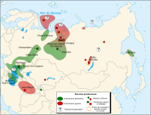
Natural gas from Siberia is about Russia coveted addition, raw material , being generally assumed that the country has the world's largest natural gas reserves. Since the late 1970s, natural gas has also been supplied to Germany (at that time: to the GDR within the framework of the Comecon and to West Germany) and today makes an important contribution to the energy supply in Central Europe . Up to 90% of Russian natural gas comes from West Siberia . The main gas fields in Siberia are:
- Yuzhno Russkoje (Agreement between Wintershall and Gazprom at the Hanover Fair , April 2005)
- Novy Urengoy or Urengoy Gas Field
- Jamburg , Tas Peninsula
- Other gas fields on the Yamal Peninsula : Bovanenkovskoye and others (not yet fully developed)
- Shtokman gas field in the Barents Sea .
- Kowykta gas field , approx. 450 kilometers north of Irkutsk .
- Vankor in the Krasnoyarsk Territory was discovered in 1988 and is scheduled to go into production by 2008.
Today Russia supplies up to 37% of the natural gas required in Germany. German (e.g. E.ON and Wintershall ) and Russian companies ( Gazprom ) work closely together in the development and use. The natural gas is delivered to Germany via long pipelines through Belarus and Ukraine . In 2005 it was decided to undertake the construction of another pipeline through the Baltic Sea , the so-called NEGP , which is also to be seen in connection with the Russian-Ukrainian gas dispute and the Russian-Belarusian energy dispute . The Nord Stream Pipeline (formerly North European Gas Pipeline, NEGP ) was inaugurated on November 8th, 2011 and transports Russian natural gas and the like. a. from the Yuzhno-Russkoye gas field through the Baltic Sea to Germany.
oil
Siberia has large oil reserves . In addition to natural gas, this extracted and exported oil represents an important source of foreign currency income for Russia. Companies such as Gazprom Neft , Lukoil , Rosneft , Surgutneftegaz and Yukos play a central role in the production. Important pipelines lead to Europe (mainly the Friendship Oil Pipeline , also known as the Druzhba Pipeline ), Japan and the People's Republic of China . However, critics also point to the increasing environmental pollution caused by the extraction of crude oil through ailing pipelines.
Important oil fields in Siberia are:
- Verkechonskoye in Eastern Siberia
- Samotlor
- Mamontowo
- Fedorovo
- Priob
- Krasnoleninsk
- Priobskoye
- Yarainerskoye
- Talina
gold
Gold mining in Russia is an important industry. The most important gold mines are in Siberia and in the Far East (e.g. in the Amur region) as well as in the polar region. Russia currently produces around 168 tons of gold per year, making it fifth in the world. The aim is to expand production to 250 tons per year over the next five to ten years. Russia has the second largest gold reserves in the world.
Metals
The Russian mining and metallurgical company Norilsk Nickel promotes a.o. a. Iron ore in the Komsomolski mine near Norilsk in northern Siberia. Production there is estimated at 3.45 million tons of ore per year, but exact figures are not available.
Infrastructure
traffic
Since the great rivers of Siberia Ob , Yenisei and Lena drain from the south into the Arctic Ocean and are frozen over for several months each year, they are of limited importance for economic development. It was only with the construction of the Trans-Siberian Railway that goods could be transported on a larger scale.
Hydropower plants
The power of the huge currents is used in many hydropower plants. See the articles on the rivers concerned.
See also
- Indigenous peoples of the Russian North, Siberia and the Russian Far East
- New Siberian Islands
- Eastern Siberia
- Political organization of Russia
literature
- Jacek Hugo-Bader: Into the icy heart of Siberia. A trip from Moscow to Vladivostok . Piper, Munich 2014, ISBN 978-3-492-40459-4 .
- Klaus Bednarz : East of the sun . Rowohlt, Reinbek 2002, ISBN 3-498-00629-0 .
- Dittmar Dahlmann : Siberia. From the 16th century to the present , Schöningh, Paderborn 2009, ISBN 978-3-506-71361-2 .
- George Kennan: Siberia. Descriptions (of the banishment system) . Reclam, Leipzig 1890–1891 ( digitized as PDF).
- George Kennan: Tent Life in Siberia . Reclam, Leipzig 1891 ( digitized as PDF).
- Gerd Ruge : Siberian diary . Berlin Verlag, Berlin 1998/1999, ISBN 3-426-61162-7 .
- Elmar Schenkel : The Siberian pendulum. Travel in Russia . Edition Isele, Eggingen 2005, ISBN 3-86142-365-0 .
- Georg Adam Schleusing: Newly discovered Sieweria, where the sables are caught, how it is grown and inhabited anietzo… . Zittau 1693 ( digitized version ).
- Norbert Wein: Siberia . Klett-Perthes, Gotha 1999. ISBN 3-623-00693-9 .
- Gudrun Ziegler: The eighth continent. The conquest of Siberia. Ullstein, Berlin 2005. ISBN 3-550-07612-6 .
Web links
Individual evidence
- ↑ Another piece of the Russian-Chinese border, only about 70 km long, is in the Altai Mountains. Before the establishment of the Soviet Union and the independence of (outer) Mongolia from China , the Russian-Chinese border at times stretched over about 7000 km from the Pamir Mountains to the mouth of the Amur.
- ↑ Forest fires in Siberia are spreading. In: Deutsche Welle . July 31, 2019, accessed August 24, 2019 .
- ↑ Picture gallery: https://www.dw.com/de/sibirische-sintflut/g-49470887
- ↑ Fire- fighting aircraft on site - after weeks. In: Tagesschau. August 1, 2019, accessed August 24, 2019 .
- ↑ Jonathan Watts Global environment editor: Arctic wildfires spew soot and smoke cloud bigger than EU . In: The Guardian . August 12, 2019, ISSN 0261-3077 ( theguardian.com [accessed August 13, 2019]).
- ^ In the Delayed Disaster Zone , Novaya Gazeta, April 9, 2018
- ↑ Thomas Bertow: The flora and fauna of Siberia.
- ↑ Polar Census
- ↑ Berlin Institute for World Population and Global Development Chinese on their way to Siberia ( Memento from September 27, 2007 in the Internet Archive ) In: Newsletter Demos, 8th edition, May 14, 2004
- ↑ European Migration Center Berlin Viktor I. Dyatlov u. a .: The new Chinese diaspora and their admission to Irkutsk In: Migration, No. 29/30/31
- ^ The Carnegie Moscow Institut Galina Vitkovskaya: Does Chinese Migration Endanger Russian Security? In: Briefing Papers, Vol. 1, Issue 08, August 1999
- ^ Paul Goble, Tallinn, Estonia (UPI) Feb 10, 2006 Chinese Come To Russia
- ↑ Friedrich Schmidt: Siberia is not the Crimea , August 6, 2014, on faz.net
- ^ US Department of Energy - Energy Information Administration: Russia. , May 7, 2006
- ↑ Russia's future lies in Eastern Siberia and the Far East, sputniknews.com , ( Memento of the original from August 10, 2018 in the Internet Archive )
- ↑ Worldenergy.com (with Gazprom) on Russian gas markets: Archived copy ( Memento of November 16, 2005 in the Internet Archive ), August 8, 2006
- ↑ Shtokman Field in the Barents Sea: Offshore-technology.com , May 16, 2006
- ↑ Kovykta-Project by TNK and BP: Archived copy ( Memento from June 27, 2007 in the Internet Archive ), June 26, 2006
- ^ Eon - Sibirisches Erdgas: Eon-Ruhrgas.com ( Memento from June 13, 2006 in the Internet Archive ), May 7, 2006
- ↑ Centrex Group: Siberian Pipelines to Europe: Centrex.com , May 7, 2006
- ^ History of oil in Russia Sibneft: History of oil in Russia ( Memento of November 26, 2005 in the Internet Archive ), May 20, 2006
- ↑ Oil multinationals: Greenpeace: Oil spill in Siberia ( Memento of November 13, 2013 in the Internet Archive ), May 20, 2006
- ↑ Russia's Future in Eastern Siberia: WG Peace Research at the University of Kassel , May 20, 2006
- ↑ Russia's gold industry: people.com.cn , November 23, 2005
- ↑ SIBERIAN RAILWAYS
- ↑ Transsib railway lines. Cargo around lines. ( Memento from March 31, 2016 in the Internet Archive )
Coordinates: 65 ° 0 ′ 0 ″ N , 90 ° 0 ′ 0 ″ E
