Schilka (river)
|
Shilka Шилка |
||
|
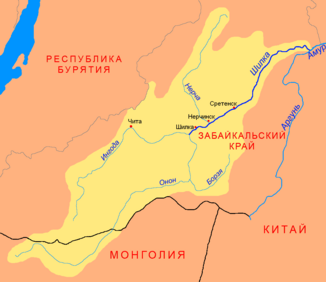
Location of the Schilka (English Shilka) in the catchment area of the Amur |
||
| Data | ||
| Water code | RU : 20030100412118100003474 | |
| location | Transbaikalia Region ( Russia ) | |
| River system | Amur | |
| Drain over | Amur → Tatar Sound | |
| Confluence of |
Ingoda and Onon 51 ° 42 ′ 21 " N , 115 ° 50 ′ 40" E |
|
| Association with |
Argun zum Amur Coordinates: 53 ° 19 ′ 58 " N , 121 ° 28 ′ 49" E 53 ° 19 ′ 58 " N , 121 ° 28 ′ 49" E
|
|
| length | 560 km | |
| Catchment area | 206,000 km² | |
| Drainage location: 149 km above the mouth |
MQ |
521 m³ / s |
| Left tributaries | Nercha , Kuenga , Tschornaja | |
| Small towns | Schilka , Nerchinsk , Sretensk | |
|
Catchment area of the Shilka (Шилка) |
||
The Schilka ( Russian Шилка ) is the 555 km long left or northern source river of the Amur in Russian Eastern Siberia .
The river , on which the city of the same name Schilka lies, was created in Russia from the union of Ingoda and Onon and is navigable from Nerchinsk . It heads for the Russian-Chinese border and joins the Argun (Ergun) to the Amur (Heilong Jiang) around 65 km west of the Chinese Xilinji , the capital of the Mohe district . Larger tributaries are the Nertscha , Kuenga, and Tschornaja , all from the left.
Larger places on the Shilka are: Sretensk and Nerchinsk in Russia.

