
Angara


The Angara ( Russian Ангара́ ) is a right tributary of the Central Siberian Yenisei in Russia .
With a water flow of 4518 m³ / s, the Angara exceeds the Yenisei at its confluence by more than half, and with a total length of around 3500 kilometers (including the Selenga river system) the length of the Yenisei with its longest source river up to this point by more than 75%. Only after leaving Lake Baikal does the river bear the name Angara and from there it has a length of 1779 km .
River course
The river rises as Upper Angara about 300 km northeast of Lake Baikal in the Stanowoj highlands . From there it flows in a westerly direction through the north of the Buryat Republic , to flow into the northeast end of Lake Baikal after 438 km in a rather extensive and marshy river delta . The lower reaches of the Upper Angara, which is one of 336 larger tributaries of the lake , is partially navigable . It supplies the lake with around 263 m³ / s (8.3 km³ / year) of water, flows through it over a length of about 600 km, in order to leave the lake not far from its southern end as Angara near the small town of Baikal east of Eastern Sayan ; there, 2071 m³ / s (65.3 km³ / year) of water flow out of the lake. By far the largest inflow of Lake Baikal is the Selenga, which feeds the lake with 951 m³ / s. So hydrologically it is the actual upper reaches of the Angara.
The Angara now flows in a north-westerly direction through the Irkutsk reservoir , at whose dam is Irkutsk . A little further north of this city, in which the Irkut coming from the southwest joins, it passes Angarsk . A few kilometers below the city, the Angara flows through the large Bratsker reservoir , where it enters the central Siberian mountains in the extreme south . In the lake, the Oka , coming from the southwest, flows towards it, roughly where it reaches the city of Bratsk . The Angara is navigable between Irkutsk and Bratsk.
Then the Angara, which in its lower reaches is often referred to as the Upper Tunguska ( Russian Верхняя Тунгуска , Verkhnyaya Tunguska ) flows over numerous rapids and through the Ust-Ilimsk reservoir , where it passes Ust-Ilimsk , and further northwest the future Bogutschanystausee , whose barrier structure has not yet been completed. Afterwards it takes up the tributary Mugieva coming from the south below Motygino , after which it cuts through the Yenisei Mountains in an east-west direction. Directly west of this mountainous landscape, it flows into the Yenisei at Strelka (just under 250 km north of Krasnoyarsk ) , which flows further north and flows into the Arctic Ocean .
Hydropower plants
The Angara is one of the world's largest sources of hydropower , with several large hydropower plants stretching along the river. The first of these is on the outskirts of Irkutsk (660 MW ; Irkutsk reservoir ), around 80 km away from Lake Baikal. There are other large power plants at Angarsk and Bratsk (4,500 MW). The dam of the Bratsk power plant on the Bratsk reservoir is one of the largest in the world, the power plant provides an average of 7.1 billion kWh of annual output.
Legends and myths
Legend has it that old Baikal loved his only daughter Angara above all else. One day when she fled to her lover Yenisei, her father threw a large stone at her out of anger. This rock, also known as the shaman stone, juts out of the water near Listvyanka and marks the border between Baikal and Angara.
The Angara is also known as the only daughter of the Baikal, as it is its only drain today, and the Baikal has more than 300 sons (tributaries).

View from Tscherski -Fels to the origin of Angara in Lake Baikal, including shamans Stone

The shaman's stone marks the limit
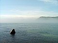
Shaman's stone that marks the beginning of the Angara
Video on the origin of the Angara in Lake Baikal

Bratsk Angara power plant


Catchment area and duration of icing
The catchment area of the Angara is around one million square kilometers (that's almost three times the area of Germany ). From the beginning of November, ice forms on the Angara, which gradually hardens into ice floes that ultimately freeze the river completely. This “ice age” usually lasts until mid-May, which means that there can be strong floods until the ice barrier has thawed. At Tatarka , before the Angara flows into the Yenisei, the flow rate is 2784 m³ / s in November (minimum) and 9350 m³ / s in May (maximum).
Tributaries
Tributaries of the Angara are:
- Barguzin - tributary of Lake Baikal through which the Angara flows
- Selenga - tributary of Lake Baikal through which the Angara flows
- Irkut - flows into the Angara in Irkutsk
- Oka - flows into the Bratsker reservoir, which the Angara flows through
- Ilim - flows into the Ust-Ilimsk reservoir, which the Angara flows through
- Tschadobez - flows below the Boguchany reservoir
- Cupyeva - flows into the lower reaches of the Angara
Lakes and reservoirs
Lakes and reservoirs on the Angara are:
- Lake Baikal (deepest lake on earth)
- Irkutsk reservoir (4.6 billion m³)
- Bratsk Reservoir (5470 km²; 169.27 km³)
- Ust-Ilimsk reservoir (1873 km²; 59.30 km³)
- Bogutschany reservoir (58.20 km³; reservoir or barrier structure not yet completed)
places
Localities on the Angara are:
Web links
Individual evidence
- ↑ a b Article Ангара in the Great Soviet Encyclopedia (BSE) , 3rd edition 1969–1978 (Russian)
- ↑ a b Angara in the State Water Register of the Russian Federation (Russian)
- ↑ For the upper reaches of the Angara by name, the Upper Angara, a length of 438 km is given, the subsequently diameter sea section through Lake Baikal is around 600 km, together around 1,049 km. The actual upper course, the much larger Selenga, has the longest stretch of river over the rivers Tuul (given as 819 km) and Orkhon . This flow path (including the lake crossing of around 130 km) is around 1,710 km long.
- ↑ a b Angara at the Tatarka gauge - hydrographic data from R-ArcticNET
- ↑ Note: Despite the large amount of runoff, it would take about 400 years for Lake Baikal, the largest freshwater body on earth, to empty.