Yenisei


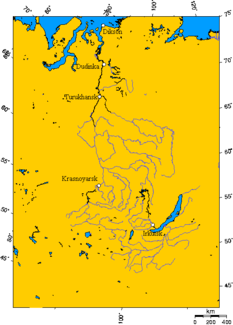
The Yenisei (also Yenisei , Russian Енисей ) is a 3487 km long river in Siberia , the Asian part of Russia , which, together with its right source river Great Yenisei, is around 4092 km long.
The river is one of the longest rivers on earth and an important shipping route that crosses Siberia from the Mongolian border in the south to the Kara Sea of the Arctic Ocean in the north. Because it flows through the country roughly in the middle along the 90th degree of longitude , it is also known as the Siberian meridian .
River name
The Evenks call the river Ioanessi . There are several theories about the origin of the name. It may be of Turkish origin and a combination of the terms ana ("mother") and say ("river") or from yeni ("new") and su ("water"). In addition, there are interpretations using other Siberian languages or dialects in the meaning of "big water" and "restless".
In the 17th century, the Cossacks coming from the west gave the river its current name: Yenisei in the later West German or “Jenissej” in the East German transcription.
geography
course
origin
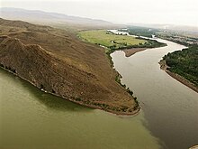
The Yenisei arises roughly in the center of the Russian Republic of Tuva , in, between the South Siberian Mountains of West Sayan (up to 3121 m ) in the northwest and north, East Sayan (up to 3492 m ) in the northeast and Tannu-ola (up to 2895 m ) in the south and southwest , Tuvinian Basin through the confluence of the Great Yenisei (see n.) And Little Yenisei (see n.), Located on the northern edge of the city of Kyzyl , at an altitude of about 619 m. In Kyzyl there is an obelisk on the southern bank of the river which, according to the inscription, marks the "Center of Asia" . The northern border of Mongolia to the south is a minimum of around 135 km away from the city.
Overview: source rivers
The right-hand source river Great Yenisei (Russian Большо́й Енисе́й, Bolshoi Yenisei ; 605 km long), the Kara-Balyk Lake in the Russian Republic of Tuva near the eastern northern border with Mongolia around 600 km west of the southern end of Lake Baikal in Eastern Sayan ( 1591 m ) flows away, runs mainly westwards and ultimately southwards to Kyzyl.
The left-hand source river Kleiner Jenissei (Russian Ма́лый Енисе́й, Maly Jenissei ; Tuvinian Bii- (Бии-Хем) and Kao-Chem (Каа-Хем); 563 km long), which is in the Dood Lake ( 1538 m ) in the main spring arm Kysyl-Chem (Кызыл-Хем) flowing away from northern Mongolia , in the Mongolian upper reaches among other things called Shishchid gol (Mong. Шишхид гол), and the shorter one, in the Russian Republic of Tuva near the Mongolian border in the Tannu-ola Mountains at around 2500 Balyktyg-Chem (Балыктыг-Хем) rises m height , flows after the union of both spring arms west-northwest to Kyzyl.
Upper course
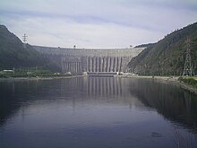
The river is called the Upper Yenisei (Russian Верхний Енисей, Tuvinian Ulug-Chem ) from the union of its source rivers - the Great and Small Yenisei - located near Kyzyl . Slightly below it - leaving the Tuvinian Basin westwards - it flows into the southern part of the Sajano-Schuschensk reservoir (540 m) located in West Sayan , about 320 km long and 621 km² , around - from the mouth of the reservoir that flows into the reservoir Chemchik only called Yenisei - to cross the border from Tuva to the Krasnoyarsk region in the reservoir . Further north, just before the 242 m high dam that stands near Cheryomushki , the Yenisei flows within the framework of the reservoir located in a narrow breakthrough valley along the border of the Krasnoyarsk region with Khakassia . Immediately to the west of the southern part of the reservoir is the Sajano-Schuschensk nature reserve (founded in 1976; 3,903.68 km²). Below the Sajano-Schuschensker reservoir, the Yenisei runs through the 11.5 km² Maina reservoir (324 m), the dam of which is south of Maina . Just east of both reservoirs is of until further down river Shushenskoye reaching National Park Schuschenski boron (founded in 1995; 391.7 square kilometers).
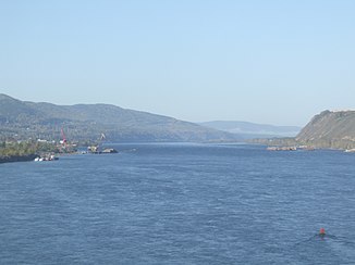
Below the village of Maina, the Yenisei flows through the agriculturally used Minussinsk Basin to the east of the Kuznetsk Alatau (max. 2211 m) , in which Sajanogorsk and, a little further north, Minussinsk , Abakan and Chernogorsk are located on the river . In the city Abakan the Jenissei open and parallel to the Abakan in the southern part of about 388 km long and 2,130 square kilometer Krasnoyarsk reservoir a (243 m), the southern part is located along the river on the border of Chakassien to Krasnoyarsk and its 124 m high dam at Divnogorsk . The river is navigable from the Minussinsk Basin ; This is made possible by a large ship lift , through which inland vessels can overcome the difference in height at the dam of the Krasnoyarsk reservoir. In a breakthrough valley, the Yenisei flows in the context of this reservoir, into which the Tuba , among other things, also flows, approximately in a northerly direction through the northwestern part of the Eastern Sayan Mountains. In the central part of the reservoir, the river finally reaches the Krasnoyarsk Territory. Below the dam and Divnogorsk flows into the Mana (142 m) at Ust-Mana . A little further east is the largest town on the river, Krasnoyarsk (138 m). There crosses a bridge of the Trans-Siberian Railway .
Middle course
From Krasnoyarsk, where the river valley widens into an agriculturally used lowland , the landscape changes: while the Yenisei leaves the Eastern Sayan there, the Central Siberian highlands are to the east and the large Western Siberian lowlands to the west, which lie between the last mentioned highlands and the far west located in the Urals and, in addition to the Yenisei, the river Ob, which is much further to the west, flows through it. From then on, the river runs northwards in the far east of the West Siberian lowlands in extensive coniferous forests .
To the northeast of Krasnoyarsk, the Kan (113 m) flows into the Yenisei near the village of Ust-Kan . A little further north, the 1779 km long Angara (76 m), coming from the east, flows in near Strelka, which flows into it after flowing through the central part of the Yenisei Mountains (max. 1104 m). Slightly below that, the Yenisei Lessosibirsk (72 m) and Jenisseisk (69 m), which now flows northwest, passes first the Kem (68 m), at Ust-Pit the Great Pit (61 m), at Nizhneshadrino the Kas (48 m) and below Jartschewo the Sym (43 m) open.
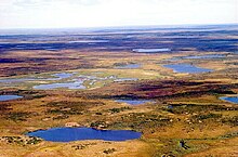
Then the 1865 km long Stony Tunguska (27 m), which comes from the Central Siberian Mountains, passes the northern end of the Yenisei Mountains and is 1865 km long, flows into Bor ; there the Yenisei forms a very extensive bend in the river. Next northwest the Jenissei flows below Werchneimbatsk the Jelogui to (16.5 m), after which it from Kangotowo pivots in the direction north-northeast. A little further downstream flows into the Yenisei, which now flows through the extensive north Siberian tundra , at Suchaja Tunguska the dry Tunguska (7.5 m).
Lower course
At the beginning of its lower reaches, in which the Yenisei, which still flows in the east of the West Siberian lowlands, runs predominantly north-northwest and is somewhat distant from the Central Siberian Mountains, flows directly above Turukhansk from the Central Siberian Mountains and 2989 km long Lower Tunguska (5.5 m) into the Yenisei and shortly afterwards the Turuchan (5 m) flows into it .
A little after the confluence of the Kureika (3 m) coming from the northeast from the Putorana Mountains near the settlement of Kureika , the Yenisei crosses the Arctic Circle . Shortly afterwards it forms an extensive river bend near Yermakowo (2 m). There, in the area of this former railway depot, the completed but abandoned route of the Arctic Circle Railway , which was never fully completed and which was built in sections from 1947 to 1953, approaches the river from the south-west. The railway line could have stayed there the river on one after Jenisseiskaja should intersect leading bridge to the east of it then north to the well situated at the Yenisei Igarka to run (1 m), but the construction project was abandoned in this region. Just north of Igarka flows east from the located near the putorana plateau Chantaikastausee coming Khantayka River one.
Much further north, the Yenisei reaches Dudinka , which now runs a little west of the Lontokoiski-Kamen Mountains . Its port is important for the shipping of the mineral resources extracted in the area of the city of Norilsk , which is around 100 km east of Dudinka . Shortly thereafter, the river swings west for a few kilometers to pick up the Great Cheta (0 m) above Ust-Port . In this region, the river separates the West Siberian Lowlands from the North Siberian Lowlands to the east .
A little further to the north-west, approximately from Karaul , the Yenisei forms many north- facing river arms, some several kilometers wide, some of which unite again and form the Brechowski Islands . After the final confluence of all arms, the river widens like a lake within the framework of the Brechowski shoal to the west ; in the south of this expansion, the western banks are a maximum of about 40 km from the eastern banks.
muzzle
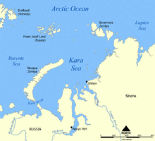
Further north again, the Yenisei, which lasts westwards, flows into the 225 km long and up to 150 km wide Jenisseigolf (Jenisseiski Zaliw), which belongs to the Kara Sea , which in turn is part of the Arctic Ocean . The sea golf - caused by the incoming Yenisei - shows a strong northerly current.
River length
For example, the length of the Yenisei can be measured in these ways:
- 3487 km = Yenisei without the 605 km long Great Yenisei (longest source river)
- 4092 km = Yenisei with the Great Yenisei
- approx. 5497 km km = Ider - Selenga - Angara - Jenissei (below the Angara estuary) = total length of the three first named rivers (approx. 452 + 1024 + 1779 km), length of the Yenisei downstream from the confluence of the Angara (approx. 2137 km) and the stretch of flow in Lake Baikal between the Selenga influence in the lake and the Angara outflow from the lake - the direct route (approximately as the crow flies ) is around 105 km; thus this river is the longest river in Russia.
Catchment area, annual runoff and ice drift
The catchment area of the Yenisei is around 2,580,000 km² (more than 7.2 times the area of Germany ); above Igarka there are still 2,440,000 km². The mean annual discharge is about 19,600 m³ / s, at Igarka in January 1995 it was 7960 m³ / s and in June 1995 it was 62,613 m³ / s. The Yenisei is considered to be the most water-rich river in Siberia. From November onwards, ice forms on the Yenisei, which gradually hardens into ice floes that ultimately freeze the river completely. This usually lasts until May, when it starts to thaw. The resulting flood, which also flows into the Yenisei from its tributaries, causes it to rise by up to ten meters in the upper and middle reaches and by up to 20 m in the lower reaches.
Source and tributaries
Rivers with orographic allocation (l = left side; r = right side), length in kilometers (km), approximate direction of influence, position of the mouth and kilometers of the Yenisei river above the mouth in the Kara Sea:
The Yenisei has two source rivers:
- r: Big Yenisei ( Bolshoi Yenisei ; 605 km), from the north, in Kyzyl ; km 3487
- l: Little Yenisei ( Maly Jenissei ; 563 km), from the east, in Kyzyl; km 3487
These tributaries flow into the Yenisei (those with a length of more than 1000 km are printed in bold ; viewed downstream):
- l: Elegest (177 km), from the south, at Ust-Elegest ; km 3454
- l: Chemtschik (320 km), from the west, in the Sajano-Schuschensk reservoir ; km 3299
- r: Us (236 km), from the east, in the Sajano-Schuschensk reservoir; km 3232
- l: Kantegir (209 km), from the southwest, in the Sajano-Schuschensker reservoir; km 3061
- r: Oja (254 km), from the southeast, below Kazantsevo ; km 2948
- l: Abakan (514 km), from the southwest, in the Krasnoyarsk reservoir , near Abakan ; km 2887
- r: Tuba (119 km), from the east, in the Krasnoyarsk reservoir, near Nikolo-Petrowka ; km 2854
- r: Syda (207 km), from the east, in the Krasnoyarsk reservoir, above Krasnoturansk ; km 2795
- r: Ubei (104 km), from the south, in the Krasnoyarsk reservoir, below Novoselowo ; km 2644
- r: Sissim (270 km), from the south, in the Krasnoyarsk reservoir, below Novoselowo; km 2632
- r: Derbina (146 km), from the south, in the Krasnoyarsk reservoir, below Cheryomushki ; km 2558
- r: Mana (475 km), from the southeast, below Divnogorsk , near Ust-Mana ; km 2488
- r: Basaicha (128 km), from the southeast, in Krasnoyarsk ; km 2468
- l: Katscha (102 km), from the northwest, in Krasnoyarsk; km 2460
- r: Esaulowka (137 km), from the south, directly below Esaulowo ; km 2418
- r: Kan (629 km), from the southeast, near Ust-Kan ; km 2356
- l: Busim (124 km), from the southwest, directly above Pavlovshchina ; km 2333
- l: Upper Podjomnaja (88 km), from the south-west, below Yuksejewo ; km 2298
- l: Lower Podjomnaja (98 km), from the west, below Juksejewo; km 2288
- r: Schilka (105 km), from east-southeast, above Piskunowka ; km 2230
- r: Jagodkina (112 km), from east-south-east, directly below Kazachinskoye ; km 2201
- r: Angara (1,779 km), from the east, near Strelka ; km 2137
- l: Kem (356 km), from the south-southwest, between Yenisseisk and Ust-Kem ; km 2045
- r: Großer Pit (415 km), from the east, directly below Ust-Pit ; km 1955
- r: Kija (134 km), from the northeast, some below Ust-Pit; km 1934
- l: Putscheglasicha (104 km), from the south, below Ponomarjobo ; km 1900
- l: Tschistoklet (110 km), from the west, between Ponomarjobo and Nasimowo ; km 1894
- r: Tis (137 km), from the east, between Nasimowo and Nowonasimowo ; km 1873
- r: Garewka (99 km), from the northeast, between Tamarowo and Nischneschadrino ; km 1833
- l: Kas (464 km), from the southwest, below Nizhneshadrino; km 1817
- l: Galaktionicha (123 km), from the south-south-west, directly above Jartschewo ; km 1775
- l: Sym (694 km), from the southwest, between Jartschewo and Kriwljak ; km 1765
- r: Kutukas (97 km), from the northeast, above Tankowo ; km 1708
- r: Vorogowka (202 km), from the north-northeast, between Tankowo and Sotino ; km 1689
- l: Dubtsches (433 km), from the west, below Sotino; km 1670
- r: Poroschnaja (103 km), from the east, below Vorogowo ; km 1655
- r: Stony Tunguska (1,865 km), from the east, near Podkamennaja Tunguska ; km 1571
- r: Varlamowka (196 km), from the east, between Mirnoye and Bakhta ; km 1436
- r: Bachta (498 km), from the north-northeast, directly below Bachta; km 1425
- l: Sarchikha (214 km), from the southwest, a little below Bakhta; km 1422
- r: Upper Imbak (157 km), from the southeast, directly below Verkhneimbatsk ; km 1325
- l: Jelogui (464 km), from the southwest, between Verkhneimbatsk and Kangotowo; km 1311
- r: Komsa (121 km), from the northeast, between Verkhneimbatsk and Kangotowo ; km 1306
- l: Artjugina (158 km), from the southwest, between Verkhneimbatsk and Kangotowo; km 1279
- l: Surguticha (122 km), from the south-southwest, near Surguticha; km 1215
- r: Nizhny Imbak (232 km), from the southeast, across from Surguticha; km 1214
- r: Fatjanicha (211 km), from the east, between Surguticha and Vereschtschagino ; km 1184
- l: Pakulicha (208 km), from the west, between Vereschtschagino and Baklanicha ; km 1154
- r: Dry Tunguska (212 km), from the east, near Suchaja Tunguska ; km 1058
- r: Lower Tunguska (2,989 km), from the east, directly above Turukhansk ; km 990
- l: Turuchan (639 km), from the southwest, below Seliwanicha and Jakuty ; km 971
- r: Kureika (888 km), from the east, near Kureika ; km 863
- r: Sucharicha (131 km), from 131, a little above Igarka ; km 735
- l: Great Igarka (156 km), from the south, below Igarka; km 696
- r: Chantaika (174 km), from the east, between Plachino and Ust-Chantaika ; km 606
- l: Grjasnucha (125 km), from the south-southwest, between Ust-Khantaika and Potapowo ; km 558
- r: Fokina (115 km), from the northeast, a little above Potapowo ; km 541
- r: Dudinka (200 km), from the southeast, in Dudinka ; km 433
- r: Dry Dudinka (150 km), from the northeast, between Novoananinsk and Ust-Port ; km 371
- l: Small Cheta (298 km), from the south, above Ust-Port; km 333
- l: Great Cheta (646 km), from the south, above Ust-Port; km 325
- r: Jakowlewa (187 km), from the northeast, below Ladygin-Yar near Jakowlewka ; km 114
- r: Goltschikha (115 km), from the northeast, below Vorontsovo ; km 31
- r: Sopochnaja (37 km), from the north, above Sopkarga at Cape Sopochnaja Karga ; km 3
Localities
The localities on the Yenisei include (in order from origin to mouth):
- Kyzyl - capital of Tuva at the union of the Big and Small Yenisei to the Yenisei
- Shagonar - on the influence of the Yenisei in the Sayano-Shuschensk reservoir
- Sayanogorsk - on the northern edge of Western Sayan
- Shushenskoye - Lenin's place of exile
- Minussinsk - eponymous place of the Minussinsk basin
- Abakan - at the mouth of the Abakan
- Chernogorsk - a little off the Yenisei
- Divnogorsk - on the dam of the Krasnoyarsk reservoir
- Krasnoyarsk - largest city on the Yenisei - just below the Krasnoyarsk reservoir
- Sosnovoborsk - a little below Krasnoyarsk
- Zheleznogorsk - closed city with a nuclear facility Zheleznogorsk - away from the Yenisei
- Strelka - at the mouth of the Angara
- Lessosibirsk - Russian "capital" of the timber industry
- Jenisseisk - "Father of the Siberian Cities"
- Podkamennaja Tunguska - at the mouth of the Stony Tunguska
- Turukhansk - at the mouth of the Lower Tunguska ; Exile place of Josef Stalin
- Kureika - near the Arctic Circle
- Igarka - up to this seaport the Yenisei can be navigated by seagoing vessels
- Dudinka - a town with a seaport, where the natural resources extracted around Norilsk are shipped
- Ust-Port - with a “natural cold room” in the permafrost and a former fur farm
- Karaul - on the lower reaches of the Yenisei - south of the Yenisei gulf
- Dikson - at the northern end of the Yenisei gulf on the Kara Sea
history
At least two sites from the Middle Paleolithic (300,000 to 40,000 years ago) are known on the upper reaches of the Yenisei, where the bones of the woolly mammoth are associated with human remains.
During the Vistula Ice Age , about 90,000 years ago, the Barents Kara ice sheet blocked the influence of the Yenisei and Ob in the Kara Sea, among other things . In the West Siberian lowlands , a huge lake was presumably formed that drained into the Aral Sea or the Caspian Sea .
In the Stone Age the settlement area of the Glaskovo culture (approx. 3200-2400 BC) extended from the southeastern part of Russia and from northern Mongolia to the upper reaches of the Yenisei. In the Bronze Age that of the Andronowo culture (approx. 2300 to 1000 BC) reached from the Caspian Sea to the Minussinsk Basin on the Yenisei. The Okunev culture (around 2000 BC), which was widespread in the middle and upper Yenisei , also falls into this age . The Karassuk culture (around 1200 BC) also settled in this basin and in Khakassia . During the Iron Age , the people of the Tagar culture (approx. 900-300 BC), named after an island in the Yenisei, lived on the middle course of the river, especially in the Minussinsk basin.
While nomadic peoples had traversed the landscapes of the Yenisei for a long time and around 49 BC. BC first time. Kyrgyz had reached its upper reaches and there in the 9th and 10th century empire had formed, coming from the west reached Russians the river until the year 1607 to 1632 on towards the east to the Lena and 1636 to the coast of To advance into the Pacific . Before the arrival of the Russians in the early 17th century, all of Siberia had only about 217,000 indigenous people, including 36,000 Tungus (Evenks), 28,500 Yakuts, 16,000 Ugrians, 15,000 Samoyeds and 26,000 Northeast Paleoasians. By the end of the 17th century there were already more Russians than all the indigenous people put together. By the middle of the 19th century, 4.5 million Russians were already living in Siberia.
In 1940, the German Reich under Hitler and the Empire of Japan agreed on the course of the boundaries of their spheres of influence in Siberia along the Yenisei northwards into the Arctic Sea for the intended division of the world. During the Second World War , the most easterly combat of the Wehrmacht took place near Dikson on August 27, 1942 , when the central Soviet radio and weather station there was under fire from the heavy cruiser Admiral Scheer during the Wunderland operation in order to avoid Allied convoys on the Disturbing Northeast Passage .
Nansen , Nordenskiöld , Messerschmidt , Pjanda , Potanin , Schischkow , Seebohm , Strahlberg , Waldburg-Zeil and Wilkizki carried out research on the Yenisei .
As part of the Davydov Plan announced by the Council of Ministers of the USSR in 1950 , the Yenisei and Ob rivers were to be diverted in order to make the distant arid regions around the Aral Sea and the Caspian Sea usable for agriculture through irrigation . But the project was abandoned in 1986 because neither costs nor possible consequences could be estimated.
The asteroid Yenisei , discovered in 1994, was named after the Yenisei.
Economy and Transport
Economical meaning
The Yenisei and the Siberian rivers Ob and Lena , which also drain into the Arctic Ocean, are covered by ice for several months each year; their importance for the economic development of Siberia is therefore limited. It was only with the construction of the Trans-Siberian Railway that goods could be transported on a larger scale.
Reservoirs and power plants
The generation of energy by hydropower plants on the Yenisei is particularly important for the (aluminum) industry around Krasnoyarsk.
The reservoirs on the Yenisei are:
- Sajano-Schuschensker reservoir (621 km²; 31,300 million m³; 6400 MW power plant)
- Maina reservoir (11.5 km²; 116 million m³; 320 MW power plant)
- Krasnoyarsk reservoir (2130 km²; 73,300 million m³; 6000 MW power plant)
The reservoirs on the Angara tributary of the Yenisei are:
- Irkutsk reservoir (60 km long; 45,800 million m³; 660 MW power plant)
- Bratsker Reservoir (5426 km²; 169.270 million m³; 4500 MW power plant)
- Ust-Ilimsk reservoir (1873 km²; 59,300 million m³; 4,320 MW power plant)
shipping
The Yenisei is of great importance for the supply of the areas north of the Trans-Siberian Railway, although the river is frozen from around November to May. Ocean navigation is possible as far as Igarka and river navigation thanks to the large ship lift on the dam of the Krasnoyarsk reservoir near Divnogorsk upstream across the reservoir to Abakan in Khakassia . The Kasatschinski rapids or Cossack rapids above the village Kasatschinskoje were fully upstream to about 1955 and from about 2006 only sporadically by cable ship , the big ships pulling on a rope upriver overcome. In addition, there are regular passenger trips on the Yenisei from Krasnoyarsk over 2,000 km north to Dudinka, and cruises on these passenger ships . The river was also important for rafting wood from the taiga to the Lesosibirsk wood processing plant until around 2009 , while timber is now transported to the Lesosibirsk logging plant exclusively by cargo ship.
Railway lines
The railway lines leading along or partially crossing the Yenisei include:
-
Krasnoyarsk Railway with these routes:
- Achinsk to Lessosibirsk in the section Abalakowo to Lessosibirsk (with connection to Novojenisseisk )
- Mezhdurechensk about Abakan to Jurty
- Mariinsk via Krasnoyarsk to Jurty on the tracks of the Trans-Siberian Railway
- Arctic Circle Railway (construction started but not completed, therefore not in operation); south of Igarka
- Trans-Siberian Railway (completed and operational); cruising in Krasnoyarsk
Streets
The roads leading along or partly crossing the Yenisei include:
- A162 ; between Kyzyl and Sayano-Shuschensk reservoir
- M53 ; crossing northeast of Krasnoyarsk
- M54 ; from Kyzyl via Abakan and Chernogorsk to Krasnoyarsk
- P409 ; from Krasnoyarsk to Yeniseisk
fishing
Yenisei fish ( Siberian sturgeon , muksun, chir, etc.) are caught near Igarka , among other places , and a large natural cooling room was built into the permafrost in Ust-Port for this purpose .
Yenisei on the flag of the Republic of Tuva
On the flag of the Russian republic of Tuva , the blue stripes represent the at Kyzyl confluence of the rivers located Large (Tuvan Bii-Chem ) and Little Yenisey (Tuv. Kaa-Chem ) to the Upper Yenisei (Tuv. Ulug-Khem ) represents the later, only called Yenisei , flows to the Arctic Ocean.
See also
literature
- Georgij I. Kublickij: The Yenisei: a Siberian river . Brockhaus-Verlag, Leipzig, 1952.
- Hermann Mattes, Kai Pagenkopf: Nature and people on the Jenissei. Lienau, Münster 2001, ISBN 3-9801245-9-2 .
- Viktor Nikolaevič Pavlov: Lenin Memorials in Siberia. Planeta-Verlag, Moscow 1988, ISBN 5-85250-076-3 .
- Pure hum: Yenisei in a two-person kayak through Siberia , self-published, Chemnitz 2014, ISBN 978-3-00-046414-0 .
Movies
- The Yenisei. Father of all rivers. Documentary, Germany, 2004, 43:15 min., Script and director: Gordan Godec, production: Transdokumentar, WDR , film information from ARD .
- Siberia's Stream of Destiny: The Yenisei. Documentary film series in three parts of 43 minutes each, 1. From Paradise to Hell , 2. The Descendants of the Exiled , 3. To the End of the World , Germany, 2005, written and directed by Dirk Sager , production: ZDF , first broadcast : February 15, 2005, table of contents by 3sat and discussion (PDF; 401 kB) in the FAZ .
Web links
- Siberian adventure by pedal boat on the Yenisei (11 parts, 74 min) as CD / downloadable
- R-ArcticNet: measuring points in the catchment area of the Yenisei and neighboring river systems
- UNESCO Water
- Ship lift on the dam of the Krasnoyarsk reservoir near Divnogorsk (Russian)
- Historical photos of the Yenisei
Individual evidence
- ↑ a b c d e Yenisei in the State Water Register of the Russian Federation (Russian)
- ↑ Article Yenisei in the Great Soviet Encyclopedia (BSE) , 3rd edition 1969–1978 (Russian)
- ↑ Global River Discharge Monitoring: Station Igarka on grdc.sr.unh.edu
- ↑ Topographic map (1: 200.000, p. M-46-V, edition 1985), Jenissei-Ursprung (center) and a. from the confluence of the Great Yenisei (top) and the Little Yenisei (center right), from there Upper Yenisei flowing westwards and also with the Elegest flowing from the south (bottom left) on map-m46.narod.ru (with heights above sea level )
- ↑ Dirk Sager : Siberia's fate stream: The Yenisei . 3sat report in three parts Archive link ( Memento of the original from April 7, 2005 in the Internet Archive ) Info: The archive link was inserted automatically and has not yet been checked. Please check the original and archive link according to the instructions and then remove this notice.
- ↑ Yenisei at the Igarka gauge - hydrographic data from R-ArcticNET
- ↑ Yaroslav V. Kutzmin: Mammalian fauna from Palaeolithic sites in the Upper Yenisei River Basin (Southern Siberia): Review of the current zooarchaeological evidence. International Journal of Osteoarchaeology 21, 2011, pp. 218-228.
- ↑ Transsib railway lines ( Memento of the original from March 31, 2016 in the Internet Archive ) Info: The archive link was inserted automatically and has not yet been checked. Please check the original and archive link according to the instructions and then remove this notice. .
