Big pit
|
Big Pit Большой Пит (Bolshoi Pit) |
||
|
|
||
| Data | ||
| Water code | RU : 17010400112116100026318 | |
| location | Krasnoyarsk Region ( Russia ) | |
| River system | Yenisei | |
| Drain over | Yenisei → Arctic Ocean | |
| source |
Central Siberian Mountains 60 ° 6 ′ 49 ″ N , 94 ° 57 ′ 4 ″ E |
|
| Source height | approx. 550 m | |
| muzzle |
Yenisei coordinates: 59 ° 1 ′ 15 " N , 91 ° 41 ′ 47" E 59 ° 1 ′ 15 " N , 91 ° 41 ′ 47" E |
|
| Mouth height | 61 m | |
| Height difference | approx. 489 m | |
| Bottom slope | approx. 1.2 ‰ | |
| length | 415 km | |
| Catchment area | 21,700 km² | |
| Discharge at the Basa Sukhoi Pit A Eo gauge : 19,500 km² Location: 119 km above the mouth |
MQ 1960/1999 Mq 1960/1999 |
204 m³ / s 10.5 l / (s km²) |
| Left tributaries | Gorbilok, Sukhoi Pit | |
| Right tributaries | Tschirimba, Panimba, Weduga, Lendacha, Kamenka | |
| Communities | Pit-Gorodok, Brjanka, Ust-Pit | |
| Navigable | 183 km from Brjanka | |
|
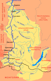
Location of the Great Pit (Большой Пит) in the catchment area of the Yenisei |
||
The Great Pit ( Russian Большой Пит , Bolshoi Pit ) is a 415 kilometer long right tributary of the Yenisei in the Central Siberian mountainous region in Russia .
course
The Great Pit rises about 550 m above sea level in the western part of the Central Siberian Mountains, east of the Yenisei Ridge and about 110 km southeast of the gold prospecting settlement Severo-Yenisiski , not far from the source of the Welmo , an important left tributary of the Stony Tunguska . After a good 15 km it takes the small pit (Maly Pit) from the left. He further flows through the taiga landscape of low mountain range in southwestern direction and intersects the axis of this section 500- 700 m high Jenisseirückens in a relatively narrow transverse valley . Then the river turns for the last 100 km of its course to the northwest and finally flows into the Yenisei at a height of 61 m 5 km below the village of Ust-Pit.
The most important tributaries are Tschirimba, Panimba, Weduga, Lendacha and Kamenka from the left and Gorbilok and Sukhoi Pit ("dry pit") from the left.
Along its entire length, the Great Pit flows through the territory of the Krasnoyarsk Territory , mainly the southeast of Severo-Yenisisky Raion . Only the lower reaches and the estuary are already on the territory of the Yeniseisk Raion .
Hydrography
The catchment area of the Great Pit covers 21,700 km². In the vicinity of the mouth, the river is about 250 m wide and 1.5 m deep; the flow velocity here is 1.2 m / s.
The Great Pit freezes from mid-November to mid-May. The water flow is 119 km above the estuary, at the confluence of the Suchoi Pit tributary an annual average of 204 m³ / s with a minimum of 30.1 m³ / s in March and a maximum of 748 m³ / s in May.
Infrastructure and economy
The Great Pit is navigable for 183 km from the settlement of Brjanka . Crossed in Bryanka, the river is also crossed by the only bridge. Over this runs the road that runs the right bank of the Yenisei opposite the cities of Lessosibirsk and Jenisseisk (bridges over the Yenisei do not exist there) with Severo-Yenisiski and the surrounding gold mining area in the area of the Welmo tributary Teja and its tributary Yenashimo further north in the Rajon connects.
Overall, the Great Pit flows through a very sparsely populated area: besides Brjanka and Ust-Pit on the right bank of the Yenisei not far from the mouth, there is only one other small settlement, Pit-Gorodok on the middle reaches.
Individual evidence
- ↑ a b Big Pit in the State Water Register of the Russian Federation (Russian)
- ↑ a b Large pit at the Basa Suchoi Pit gauge - hydrographic data from R-ArcticNET
- ^ List of Inland Waterways of the Russian Federation (confirmed by Order No. 1800 of the Government of the Russian Federation of December 19, 2002); on-line
Web links
- Article Großer Pit in the Great Soviet Encyclopedia (BSE) , 3rd edition 1969–1978 (Russian)
