Maina reservoir
| Maina reservoir | |||||||||
|---|---|---|---|---|---|---|---|---|---|
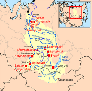
| Location of the reservoir (Mainskaya) in the Yenisei catchment area | |||||||||
|
|||||||||
|
|
|||||||||
| Coordinates | 52 ° 58 ′ 0 ″ N , 91 ° 30 ′ 0 ″ E | ||||||||
| Data on the structure | |||||||||
| Construction time: | 1979-1987 | ||||||||
| Crown length: | 750 m | ||||||||
| Power plant output: | 320 MW | ||||||||
| Operator: | RusHydro | ||||||||
| Data on the reservoir | |||||||||
| Water surface | 11.5 km² | ||||||||
| Reservoir length | 21.5 km | ||||||||
| Reservoir width | 500 m | ||||||||
| Storage space | 70.9 million m³ | ||||||||
| Total storage space : | 116 million m³ | ||||||||
| Particularities: |
Regulation of the outflow of the Sayano-Shushensk reservoir |
||||||||
The Maina reservoir uses the hydropower of the Yenisei on its way through the western Sayan Mountains between the Sajano-Schuschensk reservoir and the Krasnoyarsk reservoir . It lies on the border of Khakassia (left bank) and the Krasnoyarsk region (right bank) in southern Siberia ( Russia ).
The reservoir was created between 1979 and 1987 to regulate the outflow of the much larger Sajano-Schuschensk reservoir by LenHydroProject. It is 21.5 km long and an average of 0.5 km wide. The average water depth is 13 m, the maximum storage height 19.6 m. A hydropower plant with an installed capacity of 320 megawatts is integrated into the 750 meter long dam, with an average annual electricity production of 1.72 billion kWh .
See also
Individual evidence
- ↑ Data of the Maina reservoir ( memento of the original from June 14, 2018 in the Internet Archive ) Info: The archive link was automatically inserted and not yet checked. Please check the original and archive link according to the instructions and then remove this notice. at the operator RusHydro (Russian)

